 Block
BlockFrom the record
One of 15 National Register listings published here for Gonzales County · listed in 1971 · category: Building.
Sources: the case file at the National Archives · the National Register database, National Park Service
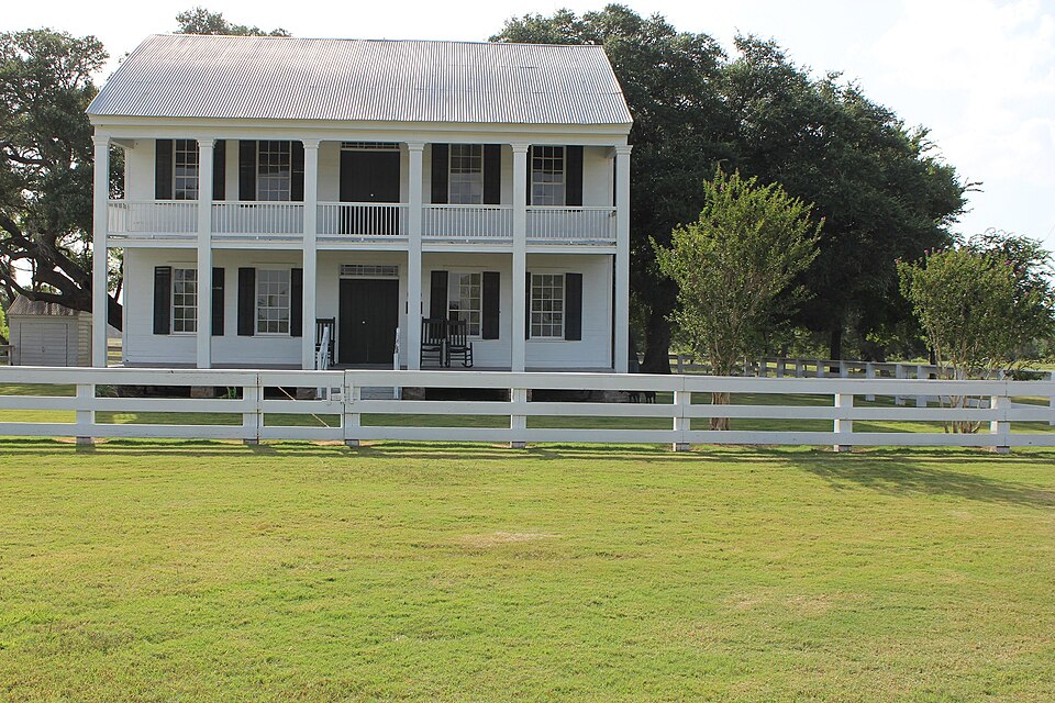
Listed on the National Register of Historic Places in 1971.
One of 15 National Register listings published here for Gonzales County · listed in 1971 · category: Building.
Sources: the case file at the National Archives · the National Register database, National Park Service
Regional context, not property-specific evidence. The federal wildfire occurrence database lists 12 fires within 5 miles of Braches House between 2003 and 2017, burning about 691 acres in total. 2 started naturally. None was recorded as arson. Distance is straight-line from the map coordinates, so a fire counted here may appear on a neighbouring settlement's page as well.
| Reported cause | Fires |
|---|---|
| Equipment and vehicle use | 5 |
| Debris and open burning | 5 |
| Natural | 2 |
The most recent of them, most recent first, with the day each was reported and the service that recorded it.
| Date | Cause | Size | Reported by | Name on the report |
|---|---|---|---|---|
| 27 September 2008 | Equipment and vehicle use | 25 acres | Texas A & M Forest Service | not named |
| 28 August 2010 | Debris and open burning | 4.0 acres | Texas A & M Forest Service | JRAL FIRE |
| 21 August 2009 | Natural | under an acre | Texas A & M Forest Service | FRANK JRAL |
| 13 July 2017 | Natural | 28 acres | Texas A & M Forest Service | JP RANCH |
| 16 June 2008 | Equipment and vehicle use | 20 acres | Texas A & M Forest Service | not named |
| 13 June 2003 | Debris and open burning | 3.0 acres | Texas A & M Forest Service | not named |
| 8 February 2011 | Equipment and vehicle use | 125 acres | Texas A & M Forest Service | STAFFORD FIRE |
| 8 February 2011 | Debris and open burning | 200 acres | Texas A & M Forest Service | CR 360 |
Regional context, not property-specific evidence. The federal mineral resources record lists 5 workings within 5 miles of Braches House: 5 producers. All of them still produce. What was taken out: Bentonite. Distance is straight-line from the map coordinates, so a quarry counted here may appear on a neighbouring settlement's page as well.
| Where | Site | Commodity | Status | Recorded |
|---|---|---|---|---|
| Helms Pit | Bentonite | Producer | Sedimentary | |
| Helms Pit | Bentonite | Producer | ||
| Kennard Pit | Bentonite | Producer | Sedimentary | |
| Knorr Pit | Bentonite | Producer | Sedimentary | |
| Southern Clay Pits and Plant | Bentonite | Producer |
Regional context, not property-specific evidence. The National Weather Service names Gonzales, the town this property stands in, in 42 storm reports between 1993 and 2024: 18 thunderstorm wind, 10 hail, 8 flash flood, 2 tornado. The reports record 6 injuries. Each account below is quoted exactly as the forecast office filed it, from the NOAA Storm Events Database, and each date opens the federal record of that event.
| When | Event | Place named | Harm | What the report says |
|---|---|---|---|---|
| September 1999 | Lightning | Gonzales | 6 hurt | no account filed |
| May 1994 | Thunderstorm Wind | Gonzales | $500,000 | Damaging winds uprooted trees, snapped power lines and telephone lines, and caused widespread damage to roofs and windows. One mobile home was damaged. |
| August 2003 | Thunderstorm Wind | Gonzales | $90,000 | As the line of thunderstorms associated with the late season cold front moved southward into Gonzales County, they produced severe winds that knocked over trees and blew down power lines just north of Gonzales. The severe winds also damaged a trailer in the area. |
| November 2000 | Thunderstorm Wind | Gonzales | $50,000 | Severe thunderstorm winds knocked down trees and destroyed two outbuildings. |
| May 1999 | Thunderstorm Wind | Gonzales | $50,000 | no account filed |
| August 2003 | Thunderstorm Wind | Gonzales | $20,000 | Severe thunderstorm winds knocked over several trees just north of Gonzales |
| March 2000 | Thunderstorm Wind | Gonzales | $20,000 | no account filed |
| May 2019 | Thunderstorm Wind | Gonzales | $10,000 | A thunderstorm produced wind gusts estimated at 65 mph that knocked down power lines in Gonzales. |
| July 1998 | Tornado (F1) | Gonzales | $10,000 | A small and short-lived tornado struck just east of Gonzales, destroying one mobile home while also damaging 5 homes and wrapping tin roofs around poles. The tornado was preceded by severe winds that also damaged sheds and the roofs of outbuildings, as well as by large hail. |
| June 1997 | Thunderstorm Wind | Gonzales | $10,000 | Trees were blown down in the Gonzales area. |
| July 1998 | Thunderstorm Wind | Gonzales | $10,000 | no account filed |
| January 2024 | Thunderstorm Wind | Gonzales | $5,000 | A thunderstorm produced wind gusts estimated at 70 mph that knocked down a traffic light at the intersection of St. Joseph St. and St. Lawrence St. in Gonzales. |
| May 2024 | Thunderstorm Wind | Gonzales | $5,000 | A thunderstorm produced wind gusts estimated at 75 mph that snapped a tree trunk in Gonzales. |
| June 2010 | Hail | Gonzales | $5,000 | A thunderstorm produced hail up to two inches in diameter which damaged several cars. |
| May 2024 | Thunderstorm Wind | Gonzales | $2,000 | A thunderstorm produced wind gusts estimated at 60 mph that damaged some trees in Gonzales. |
| January 2024 | Hail | Gonzales | - | A thunderstorm produced golf ball size hail on Hwy 90 west of Gonzales. |
| March 2018 | Thunderstorm Wind | Gonzales | - | A thunderstorm produced wind gusts estimated at 60 mph that knocked down some one inch diameter tree limbs and some roof shingles near Gonzales. |
| June 2016 | Flash Flood | Gonzales | - | Thunderstorms produced heavy rain that caused flash flooding closing FM 108, FM 1116, FM 443, FM 1681, and CR 475. |
| March 2015 | Flash Flood | Gonzales | - | Thunderstorms produced heavy rain that caused flash flooding closing FM1116 and FM532 around Gonzales. |
| November 2014 | Thunderstorm Wind | Gonzales | - | A thunderstorm produced wind gusts estimated at 58 mph that broke off some large tree limbs. |
| November 2011 | Thunderstorm Wind | Gonzales | - | A thunderstorm produced wind gusts estimated at 58 mph which snapped numerous trees, damaged several buildings, and blew down some power line poles in Gonzales. |
| May 2011 | Thunderstorm Wind | Gonzales | - | A thunderstorm produced wind gusts estimated at 50 knots which knocked down trees on the golf course in Gonzales. |
| November 2007 | Flash Flood | Gonzales | - | Thunderstorms moved slowly across northern Gonzales County during the evening of November 17 producing very heavy rainfall. Radar estimates showed in excess of 4 inches of rain from 6 PM until midnight and CoCoRAHS observer Gonzales 6.7NNW reported 6.45 inches in 24 hours ending at 7 AM on November 18. The heavy rain led to flash flooding which closed FM 794 from Gonzales to near Harwood due to water over the road. |
| July 2007 | Flash Flood | Gonzales | - | A cluster of thunderstorms over Fayette, Gonzales, Karnes, DeWitt, and Lavaca Counties produced general 1 to 2 inch rainfall with up to 4 inches east of Gonzales. FM2091 and FM532 were closed due to flash flooding. |
| July 2007 | Flood | Gonzales | - | The Guadalupe River at Gonzales crested at 40.3 ft on 07/22 at 1330cst, where flood stage is 31 ft. |
| March 2007 | Flood | Gonzales | - | The Guadalupe River at Gonzales crested at 40.53 ft at 1030 CST on March 13, where flood stage is 31 ft. This was the 5th highest crest on record. |
| July 2007 | Flash Flood | Gonzales | - | Widespread 2 to 3 inch rain amounts fell in Wilson, Gonzales, DeWitt, Karnes and Lavaca Counties, with up to 4 inches west of Gonzales. US97 and FM466 were closed. |
| May 2007 | Thunderstorm Wind | Gonzales | - | Severe thunderstorm winds blew large limbs off trees and knocked down trees northeast of Gonzales. |
| May 2007 | Flash Flood | Gonzales | - | Scattered showers and thunderstorms produced general 1 to 2 inch rain amounts over northeast Gonzales County, with up to 4 inches near Waelder. Many rural roads, including FM1115 and SH97, were closed due to flash flooding. |
| September 2007 | Tornado (EF0) | Gonzales | - | A tornado touched down twice near SH97. It destroyed some chicken houses. The tornado was rated EF0 on the Enhanced Fujita Scale. |
| September 2006 | Flash Flood | Gonzales | - | Late afternoon thunderstorms developed from northern Wilson County through northwestern Gonzales County into southwestern Fayette County, producing general 2 to 3 inches of rain over the area. Max totals in Gonzales County were 4 inches near Waelder. SH97 and FM794 were closed through the late evening due to flash flooding. |
| July 2006 | Funnel Cloud | Gonzales | - | Two short-lived funnels were sighted by the public near Gonzales. |
| July 2004 | Flash Flood | Gonzales | - | Rainfall averaged between 2 and 3 inches in showers and thunderstorms around Gonzales. Several low water crossings were reported to be under water just before midnight. |
| September 1995 | Thunderstorm Wind | Gonzales | - | Roofs were torn off homes. Lightning caused severe damage to one home. |
| May 1993 | Hail | Gonzales | - | Dime-size hail was reported by the Sheriff's Office. |
| February 2017 | Hail | Gonzales | - | no account filed |
| April 2007 | Hail | Gonzales | - | no account filed |
| May 2006 | Hail | Gonzales | - | no account filed |
| November 2000 | Hail | Gonzales | - | no account filed |
| July 1998 | Hail | Gonzales | - | no account filed |
| February 1998 | Hail | Gonzales | - | no account filed |
| March 1998 | Hail | Gonzales | - | no account filed |
No historic map-sheet match is published for this property yet. That does not mean no map exists. This record needs a coordinate-quality review before it can be joined to a sheet boundary. Browse the county's mapped places while that work is pending.
| National Archives record | The nomination case file for reference 71000936 in Record Group 79. |
| Gonzales County | All 15 listed properties in this county. |