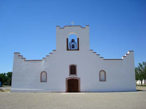
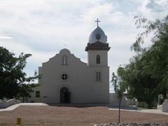
Built in 1682 (Spanish Colonial architecture). Listed on the National Register of Historic Places in 1972.
From the record
“The Socorro Mission, originally built in the late seventeenth century, is one of three Spanish missions under the stewardship of the Catholic Diocese of El Paso. The mission is a registered Texas historic landmark and listed in the national register as a site with national significance.”
Wikipedia article Socorro Mission, CC BY-SA 4.0.
One of 56 National Register listings published here for El Paso County · listed in 1972 · category: Building · built in 1682, Spanish Colonial architecture.
National Register reference number.72001359- the number the National Park Service assigned this property when it was listed, and the key its nomination file is catalogued under at the National Archives.
Fires near this property
1 since 2011
Regional context, not property-specific
evidence. The
federal wildfire occurrence database
lists 1 fire within 5 miles of Socorro Mission, Church
in 2011, burning under an acre in total. None started naturally. 1 was recorded as arson.
Distance is straight-line from the map coordinates, so a fire counted
here may appear on a neighbouring settlement's page as well.
Reported cause
Fires
Arson/incendiarism
1
The most recent of
them, most recent first, with the day each was reported and the service
that recorded it.
Regional context, not property-specific
evidence. The National Weather Service names
Socorro, the town this property stands in, in 31 storm reports between 1997 and 2025: 16 hail, 11 flash flood, 3 thunderstorm wind, 1 heavy rain.
The reports record 10 injuries. Each account below is quoted exactly as the forecast office
filed it, from the NOAA Storm Events Database, and each date
opens the federal record of that event.
Far east El Paso was hardest hit by this second supercell, with extensive golfball to possibly tennis ball size hail falling for 20 minutes. Thousands of automobiles were damaged, with several dealerships suffering much loss. Skylights were destroyed, roofs damaged and windows broken on thousands of buildings. Several injuries were reported from hailstones as well.
Supercell thunderstorms (very rare for November in this area) affected much of El Paso. The strongest, which actually weakened before moving into the United States, produced golf ball hail over far east El Paso into Horizon City. This caused record breaking insurance claims for a single hail event with a total of $200 million damage to vehicles and $100 million to homes. This doubled the previous record from 9-16-09. Flooding also occurred due to excessive hail amounts plugging up drains.
The supercell continued southeastward along I-10 for several miles. According to TxDOT, hundreds of vehicles along the interstate and other highways suffered extensive damage.
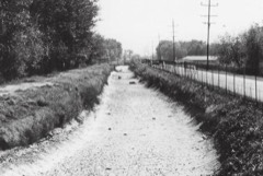
Flooding was reported along Rio Vista, Coker and Thunder Roads in Socorro. Water threatened 17 homes with 15-20 people being forced to evacuate. A 4 inch gas line was exposed near Stockyard and Alyssa Roads due to washout.
Flash flooding affected far east El Paso. Reports from TxDOT included water covering State Highway 375 near Del Valle High School and wzter covering Montana Street east of Highway 375. Also, an arroyo overflow closed part of I-10 at Eastlake Boulevard.
Horizon Boulevard below Horizon City was impassable to due rapidly moving water and debris. Floodwaters entered at least one home in the Sparks subdivision.
Flooding was reported in a strip mall parking lot on North Loop Drive north of Horizon Blvd with people playing in boats. Moderate street flooding was also reported along Socorro road about 2 miles northwest of Socorro.
KFOX reported flooding in the Socorro area near Thunder and Rio Vista Drive. Streets near the intersection had to be blocked off. Some people had to wait for the water to recede to get to their homes.
A slow moving thunderstorm produced nearly 2 inches of rain in a short time, resulting in flooded streets in the Horizon City area. Gateway West was closed in the Sparks subdivision.
No historic map-sheet match is published
for this property yet. That does not mean no map exists. This record needs
a coordinate-quality review before it can be joined to a sheet boundary.
Browse the county's mapped places while that work is
pending.
Listed places nearby
6 within 8 miles
Other National Register properties close
enough to walk or drive between, ordered by distance from this one. Both
positions come from the same geocoding pass that matched these properties
to their map sheets.
Listing record. National Park Service National Register of Historic Places, listed-properties dataset, current to 2026-05-22.
Map join. Address geocoded through the United States Census geocoder, then tested against the published boundary of every sheet in the USGS Historical Topographic Map Collection.
How this page is made. Listing fields come from federal records; map-sheet coverage is a labelled coordinate-to-boundary calculation, not a source-field claim.
Wildfire. Short, Karen C. 2022. Spatial wildfire occurrence data for the United States, 1992-2020 [FPA_FOD_20221014]. 6th Edition. Fort Collins, CO: Forest Service Research Data Archive. https://doi.org/10.2737/RDS-2013-0009.6 Collected with United States Government funding and usable without additional permissions or fees.
Storms. NOAA National Centers for Environmental Information, Storm Events Database https://www.ncei.noaa.gov/stormevents/ A work of the United States government, no copyright under 17 U.S.C. 105. Narratives are quoted verbatim from the National Weather Service report and are not edited or summarised.
 Block
Block