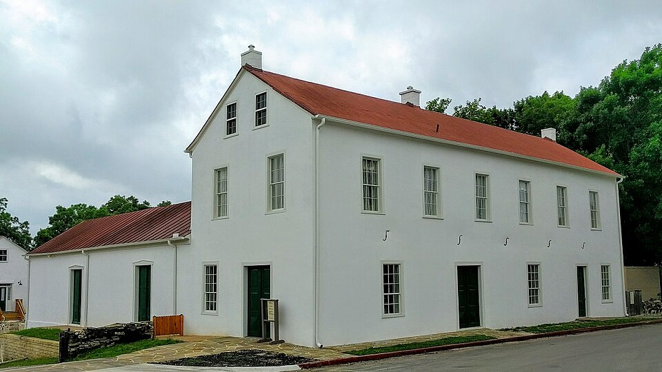
Built in 1853. Listed on the National Register of Historic Places in 1972.
From the record
“The Landmark Inn State Historic Site is a historic inn in Castroville, Texas, United States. It serves the general public as both a state historic site and inn eight overnight rooms.”
Wikipedia article Landmark Inn State Historic Site, CC BY-SA 4.0.
One of 9 National Register listings published here for Medina County · listed in 1972 · category: Building · built in 1853.
National Register reference number.72001368- the number the National Park Service assigned this property when it was listed, and the key its nomination file is catalogued under at the National Archives.
Fires near this property
82 since 2006
Regional context, not property-specific
evidence. The
federal wildfire occurrence database
lists 82 fires within 5 miles of Landmark Inn Complex
between 2006 and 2019, burning about 675 acres in total. None started naturally. None was recorded as arson.
Distance is straight-line from the map coordinates, so a fire counted
here may appear on a neighbouring settlement's page as well.
Reported cause
Fires
Missing data/not specified/undetermined
39
Equipment and vehicle use
18
Debris and open burning
18
Power generation/transmission/distribution
4
Smoking
2
Misuse of fire by a minor
1
The most recent of
them, most recent first, with the day each was reported and the service
that recorded it.
Regional context, not property-specific
evidence. The federal mineral resources record lists
4 workings within 5 miles of Landmark Inn Complex: 3 producers, 1 past producer.
3 still produce. What was taken out: Sand and Gravel, Construction, Stone, Crushed/Broken. Distance is straight-line from the
map coordinates, so a quarry counted here may appear on a neighbouring
settlement's page as well.
Regional context, not property-specific
evidence. The National Weather Service names
Castroville, the town this property stands in, in 22 storm reports between 1994 and 2022: 10 hail, 6 thunderstorm wind, 5 flash flood, 1 tornado.
No death or injury is recorded in these reports. Each account below is quoted exactly as the forecast office
filed it, from the NOAA Storm Events Database, and each date
opens the federal record of that event.
Severe thunderstorm winds struck just east of Castroville and moved southwestward through the town. Damage was first indicated approximately 2 miles east of Castroville, along the north side of US90, where 8 to 10 telephone poles had been snapped near the base. The estimated wind gusts at this point were between 80 to 100 miles per hour. The damage path was between one-quarter and one-half mile in width, with no indication of rotation or twisting. The storm continued to move toward the southwest where it damaged several mobile homes in the valley mobile home park along FM471. Much of the damage was minor, and confined to outbuildings. Numerous trees were damaged or uprooted, with limbs up to 8 inches in diameter snapped off. Several vehicle were also damaged. Wind gusts in this area were estimated in the 50 to 60 mile per hour range. As the storm continued southwestward into the Castroville area, it struck a little league baseball field complex north of the Castroville Airport. Here chain link fence was bent over in sections along the outfield fence line. Only the sections with plywood signs attached were damaged. The severe winds continued southwestward to the Airport, where they destroyed most of the The Fixed Base Operator hanger, and damaged or destroyed five aircraft and equipment housed inside hanger. Several adjacent hangers located at the airport received minor or no damage. Estimated damages from the downburst were $250,000 to aircraft, $100,000 to the hangars, and $500,000 to equipment.
Thunderstorms moving eastward through Medina County produced widespread wind damage. The Red Cross reported that 32 homes were destroyed, 44 had major damage, and 194 homes had minor damage. Numerous mobile homes suffered roof and wall damage. The city of Castroville was without power from 1639 CST until 0530 CST the next morning. Very heavy rain accompanied the storms, reducing visibility to near zero. Some of the residents reported a dark green color to the clouds just before the storm stuck. Although no large hail was reported, the hail piled into drifts along the side of the road just west of D'Hanis. Very little damage was reported at the Castroville Airport as most aircraft were tied down or put away at the time of the storms.
Extremely heavy rainfall associated with Erin spread into the east and north sections of Medina County. General rain totals in this area were between 3 and 5 inches, with up to 8 inches reported around Castroville and near the Bandera County line south of Tarpley. Most county roads north of US90 were closed due to high water.
A thunderstorm produced wind gusts estimated at 70 mph that flipped a Recreation Vehicle, uprooted several trees, blew down fences, and twisted irrigation pipes around Castroville.
The showers and thunderstorms moved into Medina County near 930 CST, with most sections of the county receiving around one-half inch of rain. The heaviest amounts were in the Castroville area where up to 2 inches of rain was reported. Roads around Castroville were closed in the mid morning due to flash flooding.
The tornado touched down very near the Fixed Base Operator hanger, where rotation was noted in a path up to 30 yards wide. The damage path was in a northeast to southwest direction which was the same track of the straight line winds. This short lived tornado was estimated to have reached F1 intensity and was likely on the ground for only a few seconds. Several witnesses in adjacent hangers described the sound of a loud train as the tornado hit the airport. Four men narrowly escaped injury by ducking for cover between two couches as it struck.
As the severe thunderstorms continued eastward across central Medina County, they produced additional severe winds that struck the town of Castroville and continued just east of Castroville. Damage was reported near the Castroville Airport as trees and power lines were blown down.
No historic map-sheet match is published
for this property yet. That does not mean no map exists. This record needs
a coordinate-quality review before it can be joined to a sheet boundary.
Browse the county's mapped places while that work is
pending.
Listed places nearby
4 within 8 miles
Other National Register properties close
enough to walk or drive between, ordered by distance from this one. Both
positions come from the same geocoding pass that matched these properties
to their map sheets.
Listing record. National Park Service National Register of Historic Places, listed-properties dataset, current to 2026-05-22.
Map join. Address geocoded through the United States Census geocoder, then tested against the published boundary of every sheet in the USGS Historical Topographic Map Collection.
How this page is made. Listing fields come from federal records; map-sheet coverage is a labelled coordinate-to-boundary calculation, not a source-field claim.
Wildfire. Short, Karen C. 2022. Spatial wildfire occurrence data for the United States, 1992-2020 [FPA_FOD_20221014]. 6th Edition. Fort Collins, CO: Forest Service Research Data Archive. https://doi.org/10.2737/RDS-2013-0009.6 Collected with United States Government funding and usable without additional permissions or fees.
Mines and quarries. USGS Mineral Resources Data System (MRDS) https://mrdata.usgs.gov/mrds/ A work of the United States government, no copyright under 17 U.S.C. 105.
Storms. NOAA National Centers for Environmental Information, Storm Events Database https://www.ncei.noaa.gov/stormevents/ A work of the United States government, no copyright under 17 U.S.C. 105. Narratives are quoted verbatim from the National Weather Service report and are not edited or summarised.
 Block
Block