
BlockBefore
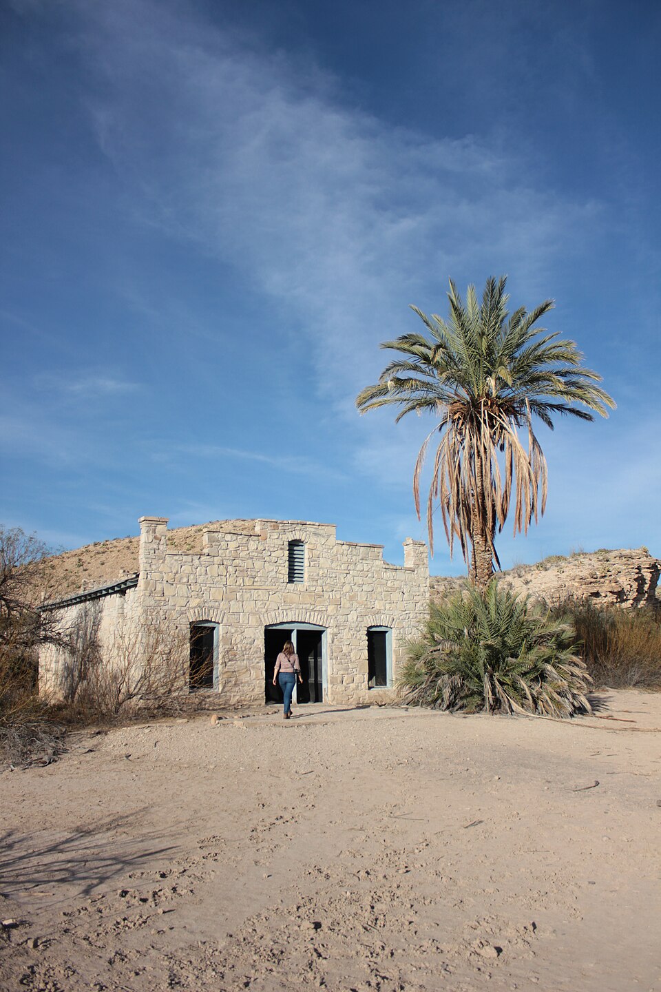
Photograph of Hot Springs
Photograph by John Cummings, CC BY-SA 3.0. Via Wikimedia Commons.

Hot Springs

Listed on the National Register of Historic Places in 1974.

From the record

“Hot Springs, also known as Boquillas Hot Springs, and Langford Hot Springs is a former thermal spring resort in what is now Big Bend National Park in Texas. Hot Springs was placed on the National Register of Historic Places in 1974.”

Wikipedia article Hot Springs (Big Bend National Park), CC BY-SA 4.0.

One of 14 National Register listings published here for Brewster County · listed in 1974 · category: Site.

Sources: the Wikipedia article · the case file at the National Archives · the National Register database, National Park Service
The listing

  • Address. W of Rio Grande Village, Big Bend National Park
  • When was it listed? September 1974
  • Category. site
  • National Register reference number. 74000278 - the number the National Park Service assigned this property when it was listed, and the key its nomination file is catalogued under at the National Archives.

Fires near this property

26 since 1993

Regional context, not property-specific evidence. The federal wildfire occurrence database lists 26 fires within 5 miles of Hot Springs between 1993 and 2017, burning about 341 acres in total. 11 started naturally. 1 was recorded as arson. Distance is straight-line from the map coordinates, so a fire counted here may appear on a neighbouring settlement's page as well.

Reported cause Fires
Natural11
Debris and open burning4
Power generation/transmission/distribution3
Smoking2
Missing data/not specified/undetermined2
Misuse of fire by a minor2
Arson/incendiarism1
Recreation and ceremony1

The most recent of them, most recent first, with the day each was reported and the service that recorded it.

DateCause SizeReported by Name on the report
8 August 2017Power generation/transmission/distributionunder an acreBig Bend National ParkHOT SPRINGS CANYON
5 August 1996Naturalunder an acreBig Bend National ParkAMPITHEATE
10 August 1999Misuse of fire by a minor13 acresBig Bend National ParkBARKER
25 July 2015Natural62 acresBig Bend National ParkCROSSING
19 July 2002Naturalunder an acreBig Bend National ParkBOQUILLAS
12 July 1994Naturalunder an acreBig Bend National ParkTUNNEL
28 June 2005Arson/incendiarism15 acresBig Bend National ParkOVERLOOK
14 June 1997Naturalunder an acreBig Bend National ParkELF

Every fire recorded in Brewster County

Mines and quarries near this property

3 within 5 miles

Regional context, not property-specific evidence. The federal mineral resources record lists 3 workings within 5 miles of Hot Springs: 3 occurrences. None of them still produces. What was taken out: Fluorine-Fluorite. Distance is straight-line from the map coordinates, so a quarry counted here may appear on a neighbouring settlement's page as well.

Where SiteCommodity StatusRecorded
Ojo CalienteFluorine-FluoriteOccurrenceFluorite
Ojo CalienteFluorine-FluoriteOccurrence
Unnamed OccurrencesFluorine-FluoriteOccurrence

Every working recorded in Brewster County

Map coverage status

No historic map-sheet match is published for this property yet. That does not mean no map exists. This record needs a coordinate-quality review before it can be joined to a sheet boundary. Browse the county's mapped places while that work is pending.

Listed places nearby

1 within 8 miles

Other National Register properties close enough to walk or drive between, ordered by distance from this one. Both positions come from the same geocoding pass that matched these properties to their map sheets.

Photograph PropertyDistance Listed
Daniels Farm House1.5 miles1989

Sources for this property

National Archives recordThe nomination case file for reference 74000278 in Record Group 79.
Wikipedia articleCommunity-written account of this property, licensed CC BY-SA.
Brewster CountyAll 14 listed properties in this county.

Provenance

  • Listing record. National Park Service National Register of Historic Places, listed-properties dataset, current to 2026-05-22.
  • Map join. Address geocoded through the United States Census geocoder, then tested against the published boundary of every sheet in the USGS Historical Topographic Map Collection.
  • How this page is made. Listing fields come from federal records; map-sheet coverage is a labelled coordinate-to-boundary calculation, not a source-field claim.
  • Wildfire. Short, Karen C. 2022. Spatial wildfire occurrence data for the United States, 1992-2020 [FPA_FOD_20221014]. 6th Edition. Fort Collins, CO: Forest Service Research Data Archive. https://doi.org/10.2737/RDS-2013-0009.6 Collected with United States Government funding and usable without additional permissions or fees.
  • Mines and quarries. USGS Mineral Resources Data System (MRDS) https://mrdata.usgs.gov/mrds/ A work of the United States government, no copyright under 17 U.S.C. 105.