 Block
BlockFrom the record
One of 3 National Register listings published here for Garza County · listed in 1975 · category: Building.
Sources: the case file at the National Archives · the National Register database, National Park Service
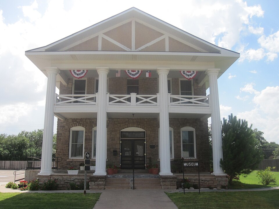
Listed on the National Register of Historic Places in 1975.
One of 3 National Register listings published here for Garza County · listed in 1975 · category: Building.
Sources: the case file at the National Archives · the National Register database, National Park Service
Regional context, not property-specific evidence. The federal wildfire occurrence database lists 20 fires within 5 miles of Old Post Sanitarium between 2005 and 2018, burning about 35,558 acres in total. 2 started naturally. None was recorded as arson. Distance is straight-line from the map coordinates, so a fire counted here may appear on a neighbouring settlement's page as well.
| Reported cause | Fires |
|---|---|
| Equipment and vehicle use | 10 |
| Missing data/not specified/undetermined | 5 |
| Natural | 2 |
| Smoking | 2 |
| Power generation/transmission/distribution | 1 |
The most recent of them, most recent first, with the day each was reported and the service that recorded it.
| Date | Cause | Size | Reported by | Name on the report |
|---|---|---|---|---|
| 12 August 2006 | Equipment and vehicle use | 1.0 acres | Texas A & M Forest Service | not named |
| 9 July 2006 | Missing data/not specified/undetermined | 1.0 acres | Texas A & M Forest Service | not named |
| 9 June 2006 | Equipment and vehicle use | 1.0 acres | Texas A & M Forest Service | not named |
| 15 May 2006 | Smoking | 1.0 acres | Texas A & M Forest Service | not named |
| 9 April 2011 | Power generation/transmission/distribution | 32,000 acres | Texas A & M Forest Service | KILLOUGH FIRE |
| 16 April 2008 | Natural | 400 acres | Texas A & M Forest Service | not named |
| 11 April 2008 | Missing data/not specified/undetermined | 100 acres | Texas A & M Forest Service | not named |
| 10 April 2011 | Missing data/not specified/undetermined | 550 acres | Texas A & M Forest Service | OAK HILL FIRE |
Regional context, not property-specific evidence. The National Weather Service names Post, the town this property stands in, in 139 storm reports between 1993 and 2026: 94 hail, 30 thunderstorm wind, 10 flash flood, 2 tornado. The reports record 1 injury. Each account below is quoted exactly as the forecast office filed it, from the NOAA Storm Events Database, and each date opens the federal record of that event.
| When | Event | Place named | Harm | What the report says |
|---|---|---|---|---|
| June 1997 | Thunderstorm Wind | Post | 1 hurt, $15,000 | no account filed |
| June 2002 | Hail | Post | $400,000 | The Garza County Sheriff's office reported baseball size hail in town. |
| June 2003 | Hail | Post | $100,000 | The Garza County Sheriff's Office reported golfball size hail. |
| August 2005 | Thunderstorm Wind | Post | $75,000 | The National Weather Service in Lubbock, Texas conducted a damage survey of impacts resultant from severe thunderstorm activity occurring across the area on Saturday, August 27 2005.An outbreak of severe thunderstorms developed across the NWS Lubbock forecast and warning area of responsibility during the late afternoon on Saturday and continued through the pre-midnight hours. A mesoscale convective system, or a large and organized complex of intense thunderstorms, developed as upper level energy pushed into the Texas Panhandle from the northwest and combined with numerous surface fronts generated from previous thunderstorm outflows. Garza county: A severe thunderstorm produced a swath of significant damage in a relatively isolated area in Garza county. The zone of greatest Impact occurred approximately 8 miles to the west of downtown Post, TX on Highway 380. The pattern of damage was consistent with a thunderstorm downburst. The downburst resulted from what is known as a rear flank downdraft (RFD). An RFD can form in severe thunderstorms as air high above begins to sink rapidly on the backside or rear of the thunderstorm. The RFD can, at times, play a significant role in the formation of a tornado. RFD winds can produce damage comparable to tornado damage, however there will generally be a circulation debris pattern evident when surveying tornado damage.The downburst pattern was bounded from 8 miles west of Post, or beginning at the intersection of Highway 380 and County Road 125, to beyond a mile just past County Road 105. The damage pattern was observed up to two miles south of this location along FM 1313.The debris field started with a snapped stop sign at the intersection of Highway 380 and County Road 125 with 3 cotton trailers and a small cylindrical oil tank blown over, all from a north to south direction. Following this location, along Highway 380, a series of power poles and lines were blown over, snapped, and/or ripped from the ground for a stretch of 1 mile by the downburst wind. All of these poles were blown from a north to south direction.Farther to the south between county roads 105/115/125 and along Fm1313, numerous large trees were snapped and/or uprooted and a few center pivot irrigation systems were blown over. A manufactured home located on County Road 125 sustained damage with layers of shingles lifted off the roof, landing a short distance in the backyard. The front attached patio/walkway was pushed toward the left-front of the home by gusty wind. The debris at this location was blown from an east to west direction and was likely the result of moderate east/southeast inflow in the immediate vicinity of the rotating mesocyclone in the severe thunderstorm. Noted was a small shed and trees adjacent to the home that sustained no impactsfrom the apparent less than severe inflow winds responsible for peeling off the shingles from the roof. No rotation was evident in the pattern of debris fall from the shingles.The Texas Tech/West Texas mesonet station, located 5 miles south of Graham, measured a 69 mph wind gust from the north at 6:35 PM CST. Graham is located approximately 6 miles southeast of the manufactured home. Interviewing local utility crews, a total of 49 power poles were destroyed and several acres of cotton were damaged and/or destroyed. |
| May 1999 | Hail | Post | $75,000 | no account filed |
| April 2009 | Hail | Post | $50,000 | Local law enforcement and fire fighting officials reported that nickel to quarter size hail covered the ground in Post. The accumulating hail combined with heavy rainfall to result in minor flooding of several city streets. A post-storm survey by the National Weather Service revealed minor damage to a number of roofs in Post, and large swaths of de-leafed mesquite trees near the city. |
| October 2006 | Flash Flood | Post | $50,000 | The Garza County Emergency Manager reported that widespread heavy rainfall resulted in flash flooding along several area highways. Flowing flood waters washed out a portion of a new driving surface along U.S. Highway 380 east of Post. A vehicle hydroplaned off of U.S. Highway 84 southeast of Post and came to rest in a flooded playa lake. The driver was rescued by local emergency officials, but did not sustain injuries. Flood waters were reported to be six to eight inches deep over several roadways. Minor flooding also was reported over the western half of the county. |
| June 1998 | Thunderstorm Wind | Post | $50,000 | no account filed |
| June 2006 | Thunderstorm Wind | Post | $30,000 | Damaging winds spread southward over Garza County as a large complex of severe thunderstorms impacted the area during the late afternoon hours on the 22nd. Storm spotters initially estimated wind gusts up to 70 MPH in Post at 15:23 CST. By 15:25 CST, local authorities reported that many large trees and utility lines had been blown down in the city. The Texas Tech West Texas Mesonet observations indicated peak gusts to 73 MPH in the vicinity. The severe winds began to affect the Lake Alan Henry area by 16:10 CST, when a gust of 69 MPH was recorded by the West Texas Mesonet near the lake. Severe thunderstorm winds intermittently gusted to near 70 MPH at the lake until 16:22 CST. A local newspaper additionally reported that some minor structural damage also occurred in Post. No injuries were reported. |
| May 2006 | Flash Flood | Post | $25,000 | Locally intense rainfall over the city of Post resulted in flash flooding along U.S. Highway 380. Fire crews rescued motorists from a submerged vehicle after it was washed off of the highway in flowing flood waters up to one and half feet deep. No injuries were reported. |
| June 2004 | Hail | Post | $25,000 | Garza County Sheriff's Office reported golfball size hail. |
| April 2007 | Hail | Post | $20,000 | The Garza County Seriff's Office reported a wide swath of large hail that ranged in size from pennies to golfballs from just southwester of Post to east-northeast of the city. Golfball size hail was reported at 20:14 CST along U.S. Highway 380 at the Double Mountain Fork of the Brazos River approximately seven miles east of Post. In addition, golfball size hail also was reported along Farm to Market Road 2008 in northeastern Garza County, near the community of Verbena, at 20:40 CST. Reports of damage were limited. |
| April 2000 | Thunderstorm Wind | Post | $15,000 | The Garza County EOC reported power poles and trees blown down by strong thunderstorm wind. The wind also damaged a carport, damaged the roof of a house, and destroyed sheds. |
| May 1999 | Thunderstorm Wind | Post | $15,000 | Strong thunderstorm wind lifted the roof off a house, blew windows out of cars and snapped power poles. |
| June 2020 | Flood | Post | $10,000 | Very heavy rainfall affected a portion of Texas State Highway 207 approximately four to five miles north of Post. Photos from social media showed that the road was damaged and impassable. |
| May 2016 | Hail | Post | $10,000 | Law enforcement in Garza County as well as a storm chaser reported hail up to five inches in and around Post along US Highway 84 and US Highway 380. The only damage reported was broken car windows. This giant hail occurred with a left moving supercell thunderstorm. |
| May 2000 | Thunderstorm Wind | Post | $10,000 | Strong thunderstorm wind blew over an 18-wheeler carrying a mobile home, broke a utility pole, and damaged the roof of a house. |
| May 2018 | Thunderstorm Wind | Post | $8,000 | A series of downbursts caused a swath of light to moderate damage from Post southeast to Lake Alan Henry. In Post, the metal roof to the city maintenance building was peeled back causing some water damage to the materials and electronics inside. Farther southeast near Lake Alan Henry, very minor damage to boat storage facilities was noted in addition to a damaged road sign. |
| April 2007 | Hail | Post | $5,000 | Local officials reported tennis ball size hail near Farm to Market Road 2008 in northeastern Garza County. Reports of damage were limited. |
| April 2007 | Hail | Post | $5,000 | A severe thunderstorm produced a swath of hail up to the size of nickels across northwestern Garza County. Hail accumulated five inches deep on U.S. Highway 84 by 13:30 CST. Snow-plows were used to remove the hail from the driving surface. Residents of northern Garza County continued to report large hail as the storm moved east of the highway. |
| May 1995 | Thunderstorm Wind | Post | $5,000 | no account filed |
| April 2012 | Hail | Post | $300 | A swath of very large hail fell from just north of Post east into eastern Garza County. A vehicle's windshield was damaged by baseball size hail two miles north of Post along highway 207. Farther east, a half-mile corridor of hail up to two inches in diameter fell at highways 380 and 208. |
| April 1993 | Hail | Post | $50 | Golf ball-size hail fell on United States Highway 380 east of Post, according to the Garza County Sheriff's Office. No significant damage resulted. |
| April 2026 | Hail | Post | - | A couple of reports were received of hail early in the morning of the 28th in and around Post. Local broadcast media relayed a report of quarter size hail in the town of Post with two inch hail to the southeast of Post. No damage was reported. |
| April 2025 | Hail | Post | - | Several reports were received of very large hail from west of Post into the city of Post. Hail sizes ranged from two inches in diameter to 3.50 inches in diameter. No damage was reported. |
| April 2025 | Tornado (EFU) | Post | - | A slow moving supercell thunderstorm produced five known tornadoes. This is the first of the five tornadoes. A report was received from the public of a brief tornado over open country. No damage was reported. |
| April 2025 | Flash Flood | Post | - | An NWS storm survey revealed significant flooding northeast of Post along several roadways. A slow moving supercell thunderstorm produced very heavy rainfall over an extended period of time over areas of rural Garza County. Water was flowing over Farm to Market Road 2008 three miles south of Farm to Market Road 651 along McDonald Creek. Most of the county roads were muddy and impassable at the time of the storm survey. |
| April 2025 | Thunderstorm Wind | Post | - | A Texas Tech University West Texas mesonet site near Post measured a wind gust to 64 mph. |
| June 2025 | Hail | Post | - | A photograph on social media showed hail up to golf ball size in Post. |
| April 2024 | Hail | Post | - | An off-duty NWS employee reported hail up to golf ball size east of Post along US Highway 380. No damage was reported. |
| November 2024 | Hail | Post | - | Multiple reports were received of one inch diameter hail in and around Post. |
| July 2023 | Thunderstorm Wind | Post | - | A Texas Tech University West Texas mesonet site near Post measured wind gusts to 59 mph at 1924 CST and 1927 CST. |
| September 2023 | Thunderstorm Wind | Post | - | A Texas Tech University West Texas mesonet site near Post measured a wind gust of 59 mph. Additionally, tree limbs of unknown size were downed upstream in western Garza County south of Southland. |
| June 2023 | Thunderstorm Wind | Post | - | A Texas Tech University West Texas mesonet site near Post measured severe wind gusts from 2015 CST through 2018 CST. A peak wind gust of 87 mph was measured at 2015 CST. |
| May 2022 | Thunderstorm Wind | Post | - | A Texas Tech University West Texas mesonet site near Post measured a wind gust of 60 mph. |
| August 2022 | Flash Flood | Post | - | The Texas Department of Transportation reported that a portion of US Highway 84 was underwater due to heavy rainfall and a large backup in traffic occurred due to the flooded roadway. |
| June 2021 | Thunderstorm Wind | Post | - | A Texas Tech University West Texas mesonet site near Post measured intermittent severe gusts from 2126 CST through 2136 CST. A peak wind gust of 62 mph was measured at 2127 CST. |
| May 2020 | Hail | Post | - | A swath of tennis ball size hail was observed from about three miles northwest of Post to about five miles north of Post. No damage was reported. |
| June 2019 | Thunderstorm Wind | Post | - | A Texas Tech University West Texas mesonet site near Post measured a wind gust to 64 mph. |
| May 2018 | Thunderstorm Wind | Post | - | Measured by a Texas Tech University West Texas mesonet. |
| May 2018 | Hail | Post | - | Hail up to golf ball size was reported along Texas State Highway 207 just north of Post. |
| March 2017 | Hail | Post | - | The Garza County Sheriff's office reported quarter size hail in the city of Post. No damage was reported. |
| July 2017 | Thunderstorm Wind | Post | - | Measured by a Texas Tech University West Texas mesonet northeast of Post. |
| May 2016 | Hail | Post | - | A storm chaser reported hail up to golf ball size in Post. No damage was reported. |
| May 2016 | Hail | Post | - | Law enforcement reported hail up to the size of tennis balls in northeastern Garza County. No damage was reported. |
| May 2016 | Hail | Post | - | The sheriff's office in Post reported quarter size hail south of Post. No damage was reported. |
| April 2015 | Thunderstorm Wind | Post | - | Measured by a Texas Tech University West Texas Mesonet near Post. At this same time, the Garza County Sheriff's Office estimated a 60 mph gust in the city. |
| September 2014 | Heavy Rain | Post | - | The Texas Tech University West Texas Mesonet station in Post recorded over two inches of rainfall. Law enforcement and Texas Department of Transportation officials observed small amounts of standing water on portions of roadways between Post and Kalgary. Low water crossings experienced typical nuisance flooding, but no road closures were reported. |
| June 2014 | Thunderstorm Wind | Post | - | Measured by a Texas Tech University West Texas Mesonet station northeast of Post. |
| May 2013 | Hail | Post | - | Law enforcement personnel in Post estimated golf ball size hail. The extent of any damage was not known. |
| March 2013 | Hail | Post | - | Law enforcement officials reported quarter size hail northeast of Post. No damage was observed. |
| June 2012 | Thunderstorm Wind | Post | - | Measured by a Texas Tech University West Texas mesonet station. |
| April 2012 | Hail | Post | - | A Lubbock TV station relayed a report of quarter size hail and power outages in Post. No damage was reported. |
| November 2011 | Hail | Post | - | Garza County law enforcement reported quarter size hail northwest of Post, on the edge of the Caprock escarpment. No damage was reported. |
| April 2010 | Hail | Post | - | Skywarn storm spotters reported nickel size hail just north of Post. |
| April 2010 | Hail | Post | - | Local emergency management officials reported golfball to baseball size hail northeast of Post. |
| April 2010 | Hail | Post | - | Local emergency management officials reported that very large baseball size hailstones intermittently mixed with more numerous golfball sized stones northeast of Post. |
| April 2009 | Heavy Rain | Post | - | A combination of heavy rainfall and accumulating hail resulted in minor flooding of several city streets in Post. No road closures or damages were reported. |
| April 2009 | Hail | Post | - | Local ranch workers interviewed during a post-storm National Weather Service survey reported that golfball size hail fell along U.S. Highway 380 on the Garza and Kent County line shortly before 18:00 CST. Large swaths of de-leafed mesquite trees marked the path of the large hail in the area. No property damage was reported. The parent storm was the same supercell thunderstorm that earlier produced giant hail near Justiceburg and Lake Alan Henry. |
| June 2009 | Hail | Post | - | Storm spotters and local law enforcement officials reported a swath of hail up to the size of quarters, and occasionally larger, from north of Post to Farm to Market Road 2008 east-northeast of the city. |
No historic map-sheet match is published for this property yet. That does not mean no map exists. This record needs a coordinate-quality review before it can be joined to a sheet boundary. Browse the county's mapped places while that work is pending.
Other National Register properties close enough to walk or drive between, ordered by distance from this one. Both positions come from the same geocoding pass that matched these properties to their map sheets.
| Photograph | Property | Distance | Listed |
|---|---|---|---|
| Garza County Courthouse | 0.2 miles | 2001 | |
| Old Algerita Hotel | 6.2 miles |
| National Archives record | The nomination case file for reference 75001984 in Record Group 79. |
| Garza County | All 3 listed properties in this county. |