 Block
BlockFrom the record
One of 18 National Register listings published here for Hill County · listed in 1977 · category: Building.
Sources: the case file at the National Archives · the National Register database, National Park Service
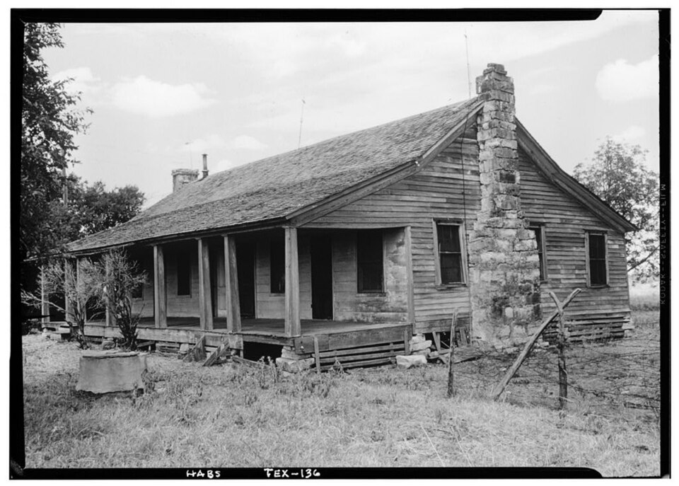
Listed on the National Register of Historic Places in 1977.
One of 18 National Register listings published here for Hill County · listed in 1977 · category: Building.
Sources: the case file at the National Archives · the National Register database, National Park Service
Regional context, not property-specific evidence. The federal wildfire occurrence database lists 177 fires within 5 miles of Joe E. Turner House between 2008 and 2020, burning about 3,350 acres in total. 4 started naturally. 11 were recorded as arson. Distance is straight-line from the map coordinates, so a fire counted here may appear on a neighbouring settlement's page as well.
| Reported cause | Fires |
|---|---|
| Debris and open burning | 68 |
| Missing data/not specified/undetermined | 64 |
| Equipment and vehicle use | 20 |
| Arson/incendiarism | 11 |
| Smoking | 6 |
| Natural | 4 |
| Railroad operations and maintenance | 2 |
| Power generation/transmission/distribution | 2 |
The most recent of them, most recent first, with the day each was reported and the service that recorded it.
| Date | Cause | Size | Reported by | Name on the report |
|---|---|---|---|---|
| 9 September 2011 | Arson/incendiarism | 1.0 acres | Texas A & M Forest Service | IH 35 -8MM |
| 7 September 2019 | Debris and open burning | 1,100 acres | Texas A & M Forest Service | FM 934 GRASS FIRE |
| 7 September 2013 | Debris and open burning | under an acre | Texas A & M Forest Service | 159 |
| 4 September 2016 | Missing data/not specified/undetermined | under an acre | Texas A & M Forest Service | IH 35 |
| 30 September 2017 | Debris and open burning | under an acre | Texas A & M Forest Service | 203 |
| 29 September 2015 | Debris and open burning | 3.0 acres | Texas A & M Forest Service | 187 |
| 29 September 2015 | Debris and open burning | 2.0 acres | Texas A & M Forest Service | 4235 |
| 29 September 2015 | Missing data/not specified/undetermined | 4.0 acres | Texas A & M Forest Service | 5571 FM 934 FIRE |
Regional context, not property-specific evidence. The National Weather Service names Itasca, the town this property stands in, in 48 storm reports between 1993 and 2026: 28 hail, 15 thunderstorm wind, 3 flash flood, 2 tornado. No death or injury is recorded in these reports. Each account below is quoted exactly as the forecast office filed it, from the NOAA Storm Events Database, and each date opens the federal record of that event.
| When | Event | Place named | Harm | What the report says |
|---|---|---|---|---|
| April 2012 | Hail | Itasca | $700,000 | Tennis ball sized hail fell in Itasca. The local newspaper reported that cars, houses, and buildings were damaged from the large hail. The hail that fell across the county also damaged the wheat crop. |
| April 2015 | Thunderstorm Wind | Itasca | $50,000 | The emergency manager reported thunderstorm wind damage to roofs and businesses in Itasca. One person was injured by a falling tree. |
| November 1994 | Thunderstorm Wind | Itasca | $50,000 | A house was unroofed and several mobile homes were blown over. |
| April 2014 | Hail | Itasca | $40,000 | Trained spotters reported ping pong ball sized hail in Itasca. |
| March 2007 | Flash Flood | Itasca | $40,000 | Many streets in Itasca and Hillsboro were closed due to flooding. Five homes and three bridges were damaged by the floodwaters, and eight high water rescues were required. |
| April 2011 | Hail | Itasca | $35,000 | The COOP Observer in Itasca reported hail stones up to 3.5 inches in diameter. |
| April 2015 | Thunderstorm Wind | Itasca | $30,000 | A tractor-trailer was overturned on Interstate 35W between mile markers 7 & 8. |
| April 2011 | Hail | Itasca | $25,000 | no account filed |
| May 2024 | Hail | Itasca | $20,000 | Public reported tennis ball, then baseball, size hail between Itasca and Hillsboro. |
| June 2006 | Thunderstorm Wind | Itasca | $20,000 | Signs and power lines were blown down. |
| January 1995 | Thunderstorm Wind | Itasca | $20,000 | High winds caused damage to the roofs of three businesses. |
| April 2026 | Hail | Itasca | $19,000 | Trained spotter reported a measured 3.25 inch hailstone in Itasca, via photo. |
| May 2002 | Thunderstorm Wind | Itasca | $15,000 | One house unroofed, several fences were blown down, and several trees were blown down. |
| April 2026 | Hail | Itasca | $13,000 | Report of 2.5 inch hail from mPING. |
| December 2015 | Thunderstorm Wind | Itasca | $12,000 | The roof and sides of a large metal barn used as a storage shed and workshop were torn off in the Itasca area. The beams of barn were made of wood. |
| April 2015 | Hail | Itasca | $10,000 | The roof of the Precinct 4 barn was damaged by hail and had to be repaired. |
| April 2011 | Hail | Itasca | $10,000 | A storm chaser observed tennis ball sized hail just west of Itasca. |
| August 1994 | Thunderstorm Wind | Itasca | $5,000 | Power lines were blown down by thunderstorm winds. |
| October 2018 | Hail | Itasca | $4,000 | Quarter size hail at interstate 35 and CR 67. |
| April 2002 | Thunderstorm Wind | Itasca | $4,000 | Power lines were blown down by high winds. |
| April 2004 | Flash Flood | Itasca | $2,000 | FM 934 near Osceola was flooded and the northbound side of Interstate 35 at mile marker 359 flooded. |
| April 1996 | Thunderstorm Wind | Itasca | $2,000 | no account filed |
| November 1996 | Thunderstorm Wind | Itasca | $2,000 | no account filed |
| September 2009 | Thunderstorm Wind | Itasca | $1,000 | Trees and 4 tree limbs were reported down in Itasca. Power lines were also down. |
| May 2024 | Hail | Itasca | - | Report from mPING: Quarter (1.00 in.). |
| April 2011 | Hail | Itasca | - | Quarter size hail fell along Interstate 35W at mile marker 11 near Itasca. |
| April 2011 | Tornado (EF0) | Itasca | - | A NWS Storm Survey determined an EF-0 tornado occurred 2 miles south-southeast of Itasca. This tornado had a path length of approximately 0.7 miles and an estimated width of 30 yards. Mostly tree damage occurred with this tornado and winds were estimated at 75 mph. The tornado was described as small and rope-like. |
| March 2008 | Flash Flood | Itasca | - | Highway 81 south of Itasca and FM 933 near the intersection of FM 934 were under water. |
| October 2001 | Thunderstorm Wind | Itasca | - | Power lines were blown down by high winds. |
| March 2000 | Tornado (F0) | Itasca | - | A brief touchdown was reported. |
| June 1998 | Thunderstorm Wind | Itasca | - | Thunderstorm winds downed trees. No dollar estimate of damage was reported. |
| April 1995 | Hail | Itasca | - | Street flooding was reported in Itasca. |
| April 1995 | Hail | Itasca | - | Highway 22 east of Hillsboro was closed due to flooding. Several Farm-to-Market roads in the area were also flooded. |
| June 1995 | Thunderstorm Wind | Itasca | - | Power lines and 18 to 20 trees were blown down by high winds. |
| April 2011 | Hail | Itasca | - | no account filed |
| April 2006 | Hail | Itasca | - | no account filed |
| December 2002 | Hail | Itasca | - | no account filed |
| May 2001 | Hail | Itasca | - | no account filed |
| March 2000 | Hail | Itasca | - | no account filed |
| April 1998 | Hail | Itasca | - | no account filed |
| March 1998 | Hail | Itasca | - | no account filed |
| October 1996 | Hail | Itasca | - | no account filed |
| October 1996 | Hail | Itasca | - | no account filed |
| January 1995 | Hail | Itasca | - | no account filed |
| January 1995 | Hail | Itasca | - | no account filed |
| April 1995 | Hail | Itasca | - | no account filed |
| October 1994 | Hail | Itasca | - | no account filed |
| October 1993 | Hail | Itasca | - | no account filed |
No historic map-sheet match is published for this property yet. That does not mean no map exists. This record needs a coordinate-quality review before it can be joined to a sheet boundary. Browse the county's mapped places while that work is pending.
| National Archives record | The nomination case file for reference 77001452 in Record Group 79. |
| Hill County | All 18 listed properties in this county. |