
BlockBefore
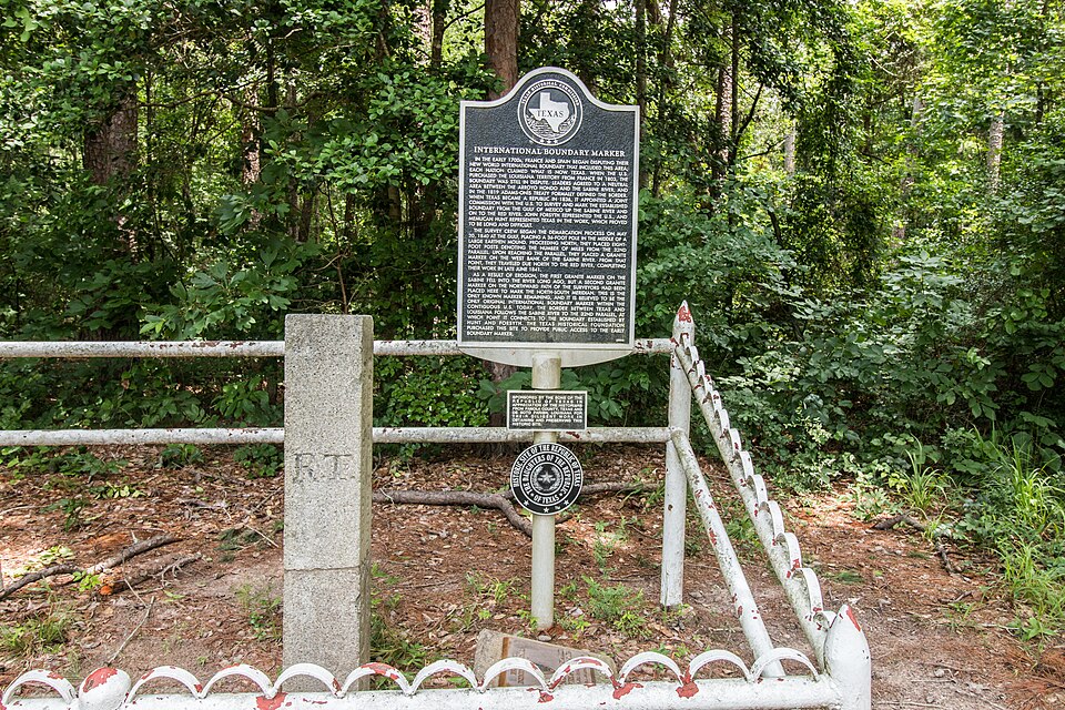
Photograph of International Boundary Marker
Photograph by Renelibrary, CC BY-SA 4.0. Via Wikimedia Commons.

International Boundary Marker

Listed on the National Register of Historic Places in 1977.

From the record

“The International Boundary Marker, also known as the Republic of Texas Granite Marker, is a boundary marker located on the Louisiana-Texas border near the junction of Texas Farm to Market Road 31 and Louisiana Highway 765, southeast of Deadwood, Texas. The marker was created in 1840 and placed in 1841 to mark the international border between the United States and the Republic of Texas.”

Wikipedia article International Boundary Marker, CC BY-SA 4.0.

One of 3 National Register listings published here for Panola County · listed in 1977 · category: Object.

Sources: the Wikipedia article · the case file at the National Archives · the National Register database, National Park Service

The listing

  • What is counted as historic. The nomination lists 1 object as contributing to the listing.
  • Address. SE of Deadwood off SR 31 at LA State line, Deadwood, 71049
  • When was it listed? April 1977
  • Category. object
  • National Register reference number. 77001463 - the number the National Park Service assigned this property when it was listed, and the key its nomination file is catalogued under at the National Archives.

Fires near this property

113 since 1992

Regional context, not property-specific evidence. The federal wildfire occurrence database lists 113 fires within 5 miles of International Boundary Marker between 1992 and 2020, burning about 452 acres in total. 6 started naturally. 5 were recorded as arson. Distance is straight-line from the map coordinates, so a fire counted here may appear on a neighbouring settlement's page as well.

Reported cause Fires
Debris and open burning65
Missing data/not specified/undetermined19
Equipment and vehicle use10
Natural6
Arson/incendiarism5
Misuse of fire by a minor3
Recreation and ceremony1
Power generation/transmission/distribution1
Railroad operations and maintenance1
Smoking1
Fireworks1

The most recent of them, most recent first, with the day each was reported and the service that recorded it.

DateCause SizeReported by Name on the report
7 September 2005Missing data/not specified/undetermined1.0 acresTexas A & M Forest Servicenot named
5 September 2006Debris and open burning1.0 acresTexas A & M Forest ServiceHENDERSON - 524
4 September 2006Debris and open burningunder an acreLouisiana Office of Forestrynot named
4 September 2000Missing data/not specified/undetermined4.0 acresTexas A & M Forest ServiceHENDERSON - 471
3 September 2013Debris and open burningunder an acreTexas A & M Forest ServiceCR 463 (KJONES)
28 September 2014Debris and open burning2.0 acresTexas A & M Forest Service6199
25 September 2015Missing data/not specified/undetermined6.2 acresLouisiana Office of Forestrynot named
25 September 2013Debris and open burning16 acresTexas A & M Forest Service6345

Every fire recorded in Panola County

Storms near this property

23 since 1993

Regional context, not property-specific evidence. The National Weather Service names Deadwood, the town this property stands in, in 23 storm reports between 1993 and 2025: 13 thunderstorm wind, 4 hail, 3 flash flood, 2 tornado. No death or injury is recorded in these reports. Each account below is quoted exactly as the forecast office filed it, from the NOAA Storm Events Database, and each date opens the federal record of that event.

WhenEvent Place namedHarm What the report says
March 1999LightningDeadwood$5,000Lightning struck a house causing a minor fire.
May 1994Thunderstorm WindDeadwood$5,000Trees were blown down onto Highway 9 by thunderstorm winds.
June 1994Thunderstorm WindDeadwood$5,000Several trees were blown down by thunderstorm winds.
January 1994Thunderstorm WindDeadwood$5,000Numerous trees were blown down on a 200 acre plot along the Sabine River. Several trees were uprooted or broken off, blocking the road.
October 2025Thunderstorm WindDeadwood-A tree was blown down near the intersection of FM 2517 and FM 31 in the Deadwood community.
May 2024Thunderstorm WindDeadwood-Trees downed on FM Road 2517 near the Deadwood community.
June 2021Flash FloodDeadwood-FM 3359 a few miles southeast of Deadwood was covered in high water and closed.
June 2021Flash FloodDeadwood-FM 31 a few miles south of Deadwood was covered in high water and closed.
June 2021Flash FloodDeadwood-FM 31 north and south of FM 2517 in the Deadwood community was covered in high rushing water.
November 2020Tornado (EF1)Deadwood-A brief EF-1 tornado with estimated maximum winds near 100 mph touched down near County Road 446 and traveled northeast for approximately a third of a mile before crossing FM 31 South near a residence. This tornado likely continued on at least a little farther downstream from this spot, but access downstream was very limited for several miles and thus the official end point of the tornado is at the crossing of FM 31 South. A few small trees were snapped at the start point of the tornado, but at FM 31 South, there were at least 10 large pine trees that were snapped or uprooted with noted signs of damage convergence. The estimated tornado path was just to the north of a residence and no real structural damage was observed.
March 2014Thunderstorm WindDeadwood-Numerous trees were downed across the eastern half of the county. Widespread power outages as well.
May 2013Thunderstorm WindDeadwood-Trees were downed in Deadwood, Texas.
April 2012Thunderstorm WindDeadwood-Four trees were downed on the eastern side of the county.
April 2011Tornado (EF2)Deadwood-The National Weather Service conducted a storm survey in Panola County Texas, and determined that a tornado first touched down in eastern Panola County near FM 3359 and then moved northeast into Desoto Parish, Louisiana. Several trees were uprooted and/or snapped just before crossing into Desoto Parish. Winds were estimated at 110 - 115 mph.
August 2009Thunderstorm WindDeadwood-Trees and powerlines wee downed in the community of Deadwood, Texas.
June 2003Thunderstorm WindDeadwood-Several large trees down.
May 1994HailDeadwood-Trees were blown down onto Highway 9 by thunderstorm winds.
April 1994Thunderstorm WindDeadwood-Several trees were blown down onto Highway 9.
May 1993Thunderstorm WindDeadwood-Several trees blown down by thunderstorm winds.
February 1993Thunderstorm WindDeadwood-Trees were blown down by thunderstorm wind.
April 1996HailDeadwood-no account filed
April 1994HailDeadwood-no account filed
March 1993HailDeadwood-no account filed

Every storm recorded in Panola County

Map coverage status

No historic map-sheet match is published for this property yet. That does not mean no map exists. This record needs a coordinate-quality review before it can be joined to a sheet boundary. Browse the county's mapped places while that work is pending.

Sources for this property

National Archives recordThe nomination case file for reference 77001463 in Record Group 79.
Wikipedia articleCommunity-written account of this property, licensed CC BY-SA.
Panola CountyAll 3 listed properties in this county.

Provenance

  • Listing record. National Park Service National Register of Historic Places, listed-properties dataset, current to 2026-05-22.
  • Map join. Address geocoded through the United States Census geocoder, then tested against the published boundary of every sheet in the USGS Historical Topographic Map Collection.
  • How this page is made. Listing fields come from federal records; map-sheet coverage is a labelled coordinate-to-boundary calculation, not a source-field claim.
  • Wildfire. Short, Karen C. 2022. Spatial wildfire occurrence data for the United States, 1992-2020 [FPA_FOD_20221014]. 6th Edition. Fort Collins, CO: Forest Service Research Data Archive. https://doi.org/10.2737/RDS-2013-0009.6 Collected with United States Government funding and usable without additional permissions or fees.
  • Storms. NOAA National Centers for Environmental Information, Storm Events Database https://www.ncei.noaa.gov/stormevents/ A work of the United States government, no copyright under 17 U.S.C. 105. Narratives are quoted verbatim from the National Weather Service report and are not edited or summarised.