 Block
BlockFrom the record
One of 3 National Register listings published here for Clay County · listed in 1978 · category: Building.
Sources: the case file at the National Archives · the National Register database, National Park Service
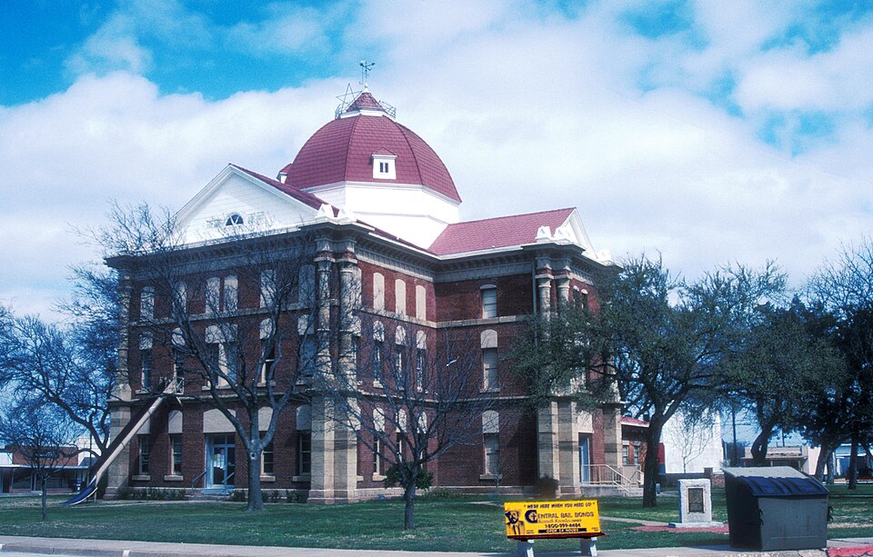
Listed on the National Register of Historic Places in 1978.
One of 3 National Register listings published here for Clay County · listed in 1978 · category: Building.
Sources: the case file at the National Archives · the National Register database, National Park Service
Regional context, not property-specific evidence. The federal wildfire occurrence database lists 146 fires within 5 miles of Clay County Courthouse and Jail between 2006 and 2020, burning about 2,100 acres in total. 18 started naturally. 3 were recorded as arson. Distance is straight-line from the map coordinates, so a fire counted here may appear on a neighbouring settlement's page as well.
| Reported cause | Fires |
|---|---|
| Missing data/not specified/undetermined | 66 |
| Debris and open burning | 21 |
| Equipment and vehicle use | 21 |
| Natural | 18 |
| Smoking | 5 |
| Railroad operations and maintenance | 4 |
| Power generation/transmission/distribution | 3 |
| Arson/incendiarism | 3 |
| Misuse of fire by a minor | 3 |
| Recreation and ceremony | 2 |
The most recent of them, most recent first, with the day each was reported and the service that recorded it.
| Date | Cause | Size | Reported by | Name on the report |
|---|---|---|---|---|
| 4 September 2011 | Natural | 1.0 acres | Texas A & M Forest Service | HAPGOOD |
| 22 September 2011 | Missing data/not specified/undetermined | 1.0 acres | Texas A & M Forest Service | U.S. HWY. 287 S. @ BROWN RD. FIRE |
| 2 September 2018 | Equipment and vehicle use | 6.0 acres | Texas A & M Forest Service | 18112 |
| 14 September 2007 | Missing data/not specified/undetermined | under an acre | Texas A & M Forest Service | not named |
| 1 September 2011 | Natural | 5.0 acres | Texas A & M Forest Service | SPRING STREET |
| 9 August 2008 | Equipment and vehicle use | 1.0 acres | Texas A & M Forest Service | not named |
| 8 August 2013 | Debris and open burning | 1.0 acres | Texas A & M Forest Service | US 287 & KLINE RD FIRE |
| 6 August 2013 | Debris and open burning | 1.0 acres | Texas A & M Forest Service | PRIDDY RANCH |
Regional context, not property-specific evidence. The federal mineral resources record lists 3 workings within 5 miles of Clay County Courthouse and Jail: 3 occurrences. None of them still produces. What was taken out: Copper. Distance is straight-line from the map coordinates, so a quarry counted here may appear on a neighbouring settlement's page as well.
| Where | Site | Commodity | Status | Recorded |
|---|---|---|---|---|
| Chrisman Ranch-1 | Copper | Occurrence | 1912 | |
| Franklin Ranch-1 | Copper | Occurrence | 1973 | |
| John Preston | Copper | Occurrence | 1874 |
Regional context, not property-specific evidence. The National Weather Service names Henrietta, the town this property stands in, in 152 storm reports between 1993 and 2026: 107 hail, 36 thunderstorm wind, 3 flash flood, 2 tornado. No death or injury is recorded in these reports. Each account below is quoted exactly as the forecast office filed it, from the NOAA Storm Events Database, and each date opens the federal record of that event.
| When | Event | Place named | Harm | What the report says |
|---|---|---|---|---|
| August 1997 | Thunderstorm Wind | Henrietta | $25,000 | Severe thunderstorm winds destroyed a mobile home. |
| June 2002 | Thunderstorm Wind | Henrietta | $20,000 | An awning at the HISD building ripped loose and tore a hole in the roof. Debris landed on two vehicles in the parking lot. |
| May 2012 | Thunderstorm Wind | Henrietta | $10,000 | Local law enforcement reported several trees and power lines down in Henrietta. Monetary damages estimated. |
| June 2007 | Thunderstorm Wind | Henrietta | $10,000 | Several power lines were downed. Most of Henrietta was without power as a result. Monetary damages were estimated. |
| August 1997 | Thunderstorm Wind | Henrietta | $10,000 | A trailer was blown over by severe thunderstorm winds. |
| August 1997 | Thunderstorm Wind | Henrietta | $10,000 | Severe winds knocked a tractor trailer over on Highway 287. |
| June 2023 | Tornado (EF1) | Henrietta | $8,000 | Spotters and chasers reported a tornado southeast of Henrietta. This tornado likely developed near New London Road about 2 miles south of US-287. It initially moved southeast, and then east crossing New York Road where a large tree was downed, an outbuilding destroyed and one house received roof damage. Chaser video showed the tornado as a slowly rotating dust column with faster moving subvorticies at times rotating around the primary circulation. |
| December 2004 | Thunderstorm Wind | Henrietta | $7,500 | Minor structural damage to a building on Highway 82 was reported. |
| June 1998 | Thunderstorm Wind | Henrietta | $7,000 | Thunderstorm winds downed trees and power lines and rolled a mobile home in a dealer's parking lot. |
| August 2013 | Thunderstorm Wind | Henrietta | $5,000 | Several six inch diameter tree limbs and one utility pole down. |
| August 2009 | Thunderstorm Wind | Henrietta | $5,000 | A large sign and tree limbs were blown down. Quarter-size hail was also reported at this locations. Monetary damages were estimated. |
| June 1997 | Thunderstorm Wind | Henrietta | $5,000 | Two trees were uprooted by severe winds, one of which landed on a car. |
| June 1994 | Thunderstorm Wind | Henrietta | $5,000 | Thunderstorm in the western part of north Texas during the evening hours on the 24th produced hail in excess of quarter-size and damaging winds. Thunderstorm winds blew shingles off of roofs from 10 to 12 miles east of Henrietta. |
| May 2008 | Thunderstorm Wind | Henrietta | $1,500 | An eight to ten foot cottonwood was snapped about half-way up due to strong winds. Monetary damages were estimated. |
| April 2002 | Thunderstorm Wind | Henrietta | $500 | Power lines were downed along Highway 287. |
| March 1998 | Thunderstorm Wind | Henrietta | $500 | Severe thunderstorm winds estimated at 70 mph downed large trees and power lines. Roofs were damaged and a small office trailer was blown over. |
| August 1997 | Thunderstorm Wind | Henrietta | $500 | Severe thunderstorm winds blew down power lines and numerous tree limbs. |
| July 1998 | Thunderstorm Wind | Henrietta | $500 | no account filed |
| May 2003 | Thunderstorm Wind | Henrietta | $100 | Many tree limbs were downed at Lake Arrowhead State Park. |
| June 1999 | Lightning | Henrietta | $10 | Lightning struck a large tree at the Clay County Courthouse. |
| April 2026 | Hail | Henrietta | - | The report was relayed through mPING. |
| April 2025 | Hail | Henrietta | - | The report was relayed through mPING. |
| May 2025 | Hail | Henrietta | - | The report was relayed through mPING. |
| May 2025 | Hail | Henrietta | - | The location is approximate. |
| March 2024 | Hail | Henrietta | - | MPing report. |
| May 2024 | Hail | Henrietta | - | Time is radar estimated. |
| May 2024 | Hail | Henrietta | - | MPing report. |
| May 2017 | Hail | Henrietta | - | Hailed for about 30 minutes. Covered the ground to a depth of 12 inches and stripped trees and shrubs of leaves. Hail was nickel to quarter size. |
| May 2017 | Thunderstorm Wind | Henrietta | - | Power poles downed. Time estimated by radar. |
| June 2016 | Flash Flood | Henrietta | - | US 82 was impassable between Henrietta and Ringgold. |
| June 2016 | Flash Flood | Henrietta | - | Farm to market 1197 was impassable north of Henrietta. |
| June 2016 | Flood | Henrietta | - | Numerous roads in Clay county had standing water. FM1197 remained closed north of Henrietta. |
| May 2015 | Thunderstorm Wind | Henrietta | - | Trees snapped and uprooted. |
| May 2015 | Hail | Henrietta | - | Delayed report. Time estimated from radar. No damage reported. |
| April 2012 | Thunderstorm Wind | Henrietta | - | A semi was blown over on Highway 287 near a roadside park. |
| May 2010 | Thunderstorm Wind | Henrietta | - | Minor roof and siding damage was reported to several buildings on the west side of town, with several tree limbs downed as well. A metal garage door was also blown in at an auto parts store. Monetary damages were not available. |
| April 2009 | Hail | Henrietta | - | The hail measured 1 3/8 inches in diameter by an off-duty Storm Prediction Center employee. The exact location was on Highway 82, on the Clay and Montague county borders. |
| April 2009 | Hail | Henrietta | - | Hail from one to two inches in diameter was reported in and around the city of Henrietta. |
| April 2009 | Hail | Henrietta | - | The hail report was relayed via the Spotter Network. |
| April 2009 | Hail | Henrietta | - | The hail report was relayed via the Spotter Network. |
| April 2009 | Hail | Henrietta | - | Hail fell for approximately six minutes. The largest hailstones were from golf-ball to 2.25 inches. The hail reports were relayed via the Spotter Network and amateur radio. |
| April 2009 | Hail | Henrietta | - | Penny- to quarter-size hail was reported. |
| April 2008 | Hail | Henrietta | - | The hail was reported on the south side of town. |
| June 2007 | Flash Flood | Henrietta | - | FM 1197 was closed due to high water. Water from Long Creek was four feet deep over the roadway. |
| June 2007 | Flood | Henrietta | - | HWY 148 was closed due to high water between Henrietta and Petrolia. |
| March 2006 | Hail | Henrietta | - | Hail was reported in downtown Henrietta. |
| June 2004 | Hail | Henrietta | - | Hail was reported at Lake Arrowhead State Park. |
| April 2002 | Hail | Henrietta | - | Hail was reported near Highways 82 and 1134. |
| June 2002 | Hail | Henrietta | - | Hail was reported near the intersection of FM 2847 and Highway 148. |
| August 2002 | Thunderstorm Wind | Henrietta | - | Wind was measured along Highway 148. |
| August 2000 | Wildfire | Henrietta | - | A large grass fire consumed 2250 acres of open pasture, just north of Highway 82. Eighty firefighters from 20 fire departments and 2 helicopters battled the fire which lasted about 6 hours. No structures were damaged, and no one was injured. |
| July 2000 | Tornado (F0) | Henrietta | - | This tornado developed north of Highway 82 in Clay County, or about 7 miles north of Henrietta, and was captured on video. The tornado lasted about 40 seconds, produced no damage, and was rated F0. |
| May 1997 | Hail | Henrietta | - | at the intersection of FM 2393 and FM 1954 |
| February 1994 | Hail | Henrietta | - | Thunderstorms in the western part of north Texas during the early morning hours on the 22nd produced hail up to two inches in diameter. Hail up to dime-size covered the ground in Archer City. Larger than golf ball-size hail fell in Westover and was on the ground for over two hours. |
| May 1994 | Hail | Henrietta | - | Thunderstorms in the western part of North Texas during the evening hours on the 25th produced one tornado, hail up to two inches in diameter and damaging winds. A tornado touched down two miles north of Quanah at 1815 CST. The F0 tornado occurred in an open field and no damage was reported. Thunderstorm winds estimated at 100 mph in combination with two inch diameter hail destroyed a 20 x 20 foot storage building, damaged a satellite dish and several homes, broke windows, downed fences and telephone poles, stripped bark from trees and destroyed the cotton and watermelon crops 4.5 miles north-northeast of Quanah. Thunderstorm winds damaged roofs and knocked down trees and transformers in Quanah, tore the roofs off of several barns just east of Quanah, knocked down the front of a store and severely damaged the roof, downed numerous trees and tree limbs and damaged railroad crossing gates in Chillicothe, damaged the roof and a door of a doctors clinic in Vernon and downed tree limbs in Benjamin and Odell. |
| July 1994 | Hail | Henrietta | - | Thunderstorms in the western part of north Texas during the evening hours of the 7th produced hail up to nickel-size and damaging winds. Thunderstorm winds uprooted trees and broke off tree limbs in Byers and damaged a mobile home just east of Byers. |
| July 1994 | Thunderstorm Wind | Henrietta | - | Thunderstorms in the western part of north Texas during the evening hours of the 7th produced hail up to nickel-size and damaging winds. Thunderstorm winds uprooted trees and broke off tree limbs in Byers and damaged a mobile home just east of Byers. |
| July 1994 | Hail | Henrietta | - | Thunderstorms in the western part of north Texas during the evening hours of the 7th produced hail up to nickel-size and damaging winds. Thunderstorm winds uprooted trees and broke off tree limbs in Byers and damaged a mobile home just east of Byers. |
| July 1994 | Hail | Henrietta | - | Thunderstorms in the western part of north Texas during the evening hours of the 7th produced hail up to nickel-size and damaging winds. Thunderstorm winds uprooted trees and broke off tree limbs in Byers and damaged a mobile home just east of Byers. |
| June 1994 | Thunderstorm Wind | Henrietta | - | Thunderstorm in the western part of north Texas during the evening hours on the 24th produced hail in excess of quarter-size and damaging winds. Thunderstorm winds blew shingles off of roofs from 10 to 12 miles east of Henrietta. |
No historic map-sheet match is published for this property yet. That does not mean no map exists. This record needs a coordinate-quality review before it can be joined to a sheet boundary. Browse the county's mapped places while that work is pending.
| National Archives record | The nomination case file for reference 78002904 in Record Group 79. |
| Clay County | All 3 listed properties in this county. |