 Block
BlockFrom the record
One of 2 National Register listings published here for Deaf Smith County · listed in 1978 · category: Building.
Sources: the case file at the National Archives · the National Register database, National Park Service
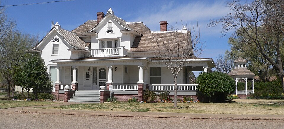
Listed on the National Register of Historic Places in 1978.
One of 2 National Register listings published here for Deaf Smith County · listed in 1978 · category: Building.
Sources: the case file at the National Archives · the National Register database, National Park Service
Regional context, not property-specific evidence. The federal wildfire occurrence database lists 43 fires within 5 miles of E. B. Black House between 2006 and 2016, burning about 370 acres in total. 2 started naturally. 5 were recorded as arson. Distance is straight-line from the map coordinates, so a fire counted here may appear on a neighbouring settlement's page as well.
| Reported cause | Fires |
|---|---|
| Equipment and vehicle use | 15 |
| Missing data/not specified/undetermined | 11 |
| Debris and open burning | 5 |
| Arson/incendiarism | 5 |
| Smoking | 4 |
| Natural | 2 |
| Misuse of fire by a minor | 1 |
The most recent of them, most recent first, with the day each was reported and the service that recorded it.
| Date | Cause | Size | Reported by | Name on the report |
|---|---|---|---|---|
| 9 September 2010 | Missing data/not specified/undetermined | 15 acres | Texas A & M Forest Service | FRIO DRAW |
| 24 August 2011 | Natural | 6.0 acres | Texas A & M Forest Service | SOUTHWEST FEEDYARD |
| 5 July 2011 | Equipment and vehicle use | 1.0 acres | Texas A & M Forest Service | BUMPER |
| 27 June 2008 | Natural | 224 acres | Texas A & M Forest Service | not named |
| 24 June 2012 | Missing data/not specified/undetermined | 1.0 acres | Texas A & M Forest Service | HAMBY FIREWORKS |
| 10 June 2011 | Debris and open burning | 8.0 acres | Texas A & M Forest Service | PALO DURO |
| 7 May 2014 | Smoking | 11 acres | Texas A & M Forest Service | BEZNER |
| 27 May 2011 | Missing data/not specified/undetermined | 1.0 acres | Texas A & M Forest Service | RD 7B |
Regional context, not property-specific evidence. The National Weather Service names Hereford, the town this property stands in, in 256 storm reports between 1993 and 2025: 143 hail, 81 thunderstorm wind, 16 flash flood, 11 tornado. No death or injury is recorded in these reports. Each account below is quoted exactly as the forecast office filed it, from the NOAA Storm Events Database, and each date opens the federal record of that event.
| When | Event | Place named | Harm | What the report says |
|---|---|---|---|---|
| June 2003 | Thunderstorm Wind | Hereford | $280,000 | A metal barn was reported destroyed and a cotton stripper was lifted and tossed by the high winds. |
| September 2004 | Flash Flood | Hereford | $180,000 | no account filed |
| May 1996 | Tornado (F2) | Hereford | $150,000 | This tornado blew the roof and some exterior walls of a brick veneer home down and destroyed the adjacent barn. Two other homes were seriously damaged. Two farm hands rode out the storm in the brick veneer home without injuries. The track is an estimate. |
| April 2003 | Thunderstorm Wind | Hereford | $125,000 | The roof off of an apartment building was blown off and damage was reported to vehicles in the parking lot. |
| June 2008 | Flash Flood | Hereford | $68,000 | The Deaf Smith County Emergency Manager reported that Park Avenue in Hereford was closed between U.S. Highway 385 and U.S. Highway 60. Also...water was reported in a few homes in the San Jose Community just south of Hereford. Water was four feet deep over Farm to Market Road 1055 about one mile south of Hereford. No injuries were reported. |
| October 2002 | Hail | Hereford | $60,000 | A center-pivot irrigation system was overturned by the damaging winds. Also...the hail damaged thousands of acres of cotton anywhere from a half mile to one and a half miles wide. The winds also nearly flattened a field of sorghum. |
| April 2025 | Tornado (EF1) | Hereford | $50,000 | This tornado touched down near County Road K and FM 1058. It caused damage to a property near this intersection, including some minor roofing damage and a few snapped trees. As this tornado crossed FM1058, seemingly tracking to the north to northwest, it broke a couple of power poles. It looked to continue along County Road K, where it deposited some debris and partially overturned an irrigation pivot before lifting. Given limited damage indicators, track of the tornado is also estimated using radar data. The maximum estimated winds with this tornado was 100mph. Thank you to the Deaf Smith County Emergency Management for their help in the completion of this tornado survey. |
| August 2008 | Flash Flood | Hereford | $28,000 | The Hereford Fire Department made high water rescues of motorists caught in low spots along U.S. Highway 60 east of Hereford. No injuries were reported. |
| September 2007 | Thunderstorm Wind | Hereford | $28,000 | Eighty-foot power poles were destroyed by high winds along U.S. Highway 60 just southwest of Hereford. The time of the damage was estimated based on radar and the wind speed was also estimated. |
| May 2005 | Hail | Hereford | $26,000 | The hail chopped leaves from corn crops...destroyed tall wheat...and denuded cotton plants. Also...the large hail stripped the paint off a barn between Milo Center and Dawn and broke the skylights of a farm home five miles north of the Hereford Municipal Airport. |
| June 2004 | Thunderstorm Wind | Hereford | $23,000 | Large trees were reported blown over by the high winds with one tree landing on a pickup truck. There was also large glass blown out of a building in the town of Bootleg. |
| June 2008 | Thunderstorm Wind | Hereford | $18,000 | Strong thunderstorm winds blew the roof off of a mobile home and also blew down power lines in Hereford. The gusts were estimated in part based on damage. |
| June 2009 | Thunderstorm Wind | Hereford | $15,000 | The Hereford Fire Department reported that a roof had been blown off a lumber yard and that small tree limbs were downed by the strong thunderstorm wind gusts. |
| June 2009 | Thunderstorm Wind | Hereford | $14,000 | The Deaf Smith County Emergency Manager reported that ten power poles had been blown down near the intersection of Farm to Market Road 2856 and Farm to Market Road 1058 west of Hereford by the thunderstorm wind gusts. Also...a well house had been blwon away off of Farm to Market Road 1057 about eight miles north of Farm to Market Road 1058. |
| May 2008 | Thunderstorm Wind | Hereford | $10,000 | Trained spotter reported that a barn had blown some forty feet away from its original place. |
| May 2024 | Hail | Hereford | $10,000 | no account filed |
| June 2009 | Thunderstorm Wind | Hereford | $8,000 | A trained spotter reported that the thunderstorm wind gusts caused damage to some roofing material and also that numerous tree limbs had been blown down. |
| October 2000 | Thunderstorm Wind | Hereford | $8,000 | Power lines were blown down...barn was destroyed and a roof was blown off of a mobile home. |
| August 2004 | Thunderstorm Wind | Hereford | $8,000 | no account filed |
| June 2009 | Thunderstorm Wind | Hereford | $6,000 | The Deaf Smith County Emergency Manager reported that thunderstorm wind gusts had blown down some power poles west of Hereford. |
| April 1999 | Thunderstorm Wind | Hereford | $5,000 | no account filed |
| June 1996 | Thunderstorm Wind | Hereford | $5,000 | no account filed |
| June 1994 | Hail | Hereford | $5,000 | no account filed |
| August 2009 | Thunderstorm Wind | Hereford | $3,000 | The Hereford Cooperative Observer estimated thunderstorm wind gusts of fifty-two knots along with blowing dirt. The Cooperative Observer also reported that there was damage to some small tree limbs and fences. |
| June 2008 | Thunderstorm Wind | Hereford | $3,000 | The strong thunderstorm winds broke off four inch tree limbs. |
| June 2008 | Hail | Hereford | $3,000 | The public reported that the large hail destroyed sky lights in a home near County Road 3 and Farm to Market Road 1057. |
| August 2013 | Thunderstorm Wind | Hereford | $2,000 | A line of thunderstorms moved eastward across Deaf Smith County during the evening hours of the 8th. As the line moved towards the town of Hereford (Deaf Smith County), another embedded core descended and produced a downburst. This downburst knocked power lines down across the city of Hereford (Deaf Smith County) as reported by the Deaf Smith County Emergency Manager. The line continued moving eastward across the county after producing this downburst, and no injuries were reported in association to this damage. |
| July 2009 | Thunderstorm Wind | Hereford | $1,000 | The public reported that a fence had been blown down. |
| August 2013 | Thunderstorm Wind | Hereford | $500 | A line of thunderstorms moved eastward across Deaf Smith County during the evening hours of the 8th. As the line moved towards the town of Hereford (Deaf Smith County), an embedded core descended and produced a localized downburst. This downburst knocked limbs off of trees and broke a skylight of a house 2 miles south-southwest of Hereford (Deaf Smith County). The line continued moving eastward across the county after producing this downburst, and no injuries were reported in association to this damage. |
| May 2025 | Hail | Hereford | - | A supercell thunderstorm produced half dollar sized hail in Hereford. |
| May 2025 | Thunderstorm Wind | Hereford | - | Winds gusted between 59 and 68 mph between 2054CDT and 2059CDT. |
| May 2023 | Flash Flood | Hereford | - | The parking lot of Dameron Park was flooded. Around 2 inches of rain was measured in 30 minutes by local ground observation stations. |
| May 2023 | Flash Flood | Hereford | - | Local media had reported that water was getting into businesses around Hereford. |
| May 2023 | Flash Flood | Hereford | - | Multiple vehicles with people inside, wound up in the ditch on US Highway 60. Reports of 6 inches of hail and 4 inches of water in the area. Water from Tierra Blanca Creek was reported to overtake the bottom of the Highway 60 bridge and start flowing over the highway. |
| May 2022 | Thunderstorm Wind | Hereford | - | A gas pump was blown over on top of a car at the gas station. There was other damage and debris around. |
| May 2022 | Thunderstorm Wind | Hereford | - | The mesonet located near Hereford, TX measured an initial severe gust at 1839CDT, with a peak gust of 67 mph at 1841CDT. |
| May 2022 | Hail | Hereford | - | Windows on a house were broken by the tennis ball size hail. |
| July 2021 | Flood | Hereford | - | Water over HWY 385 causing nuisance flooding was reported. |
| July 2021 | Flood | Hereford | - | Water over HWY 385 causing nuisance flooding was reported. |
| July 2021 | Thunderstorm Wind | Hereford | - | Tree limbs upwards of 3 inches and diameter were snapped. |
| October 2021 | Hail | Hereford | - | Hail was 2 inches deep for one mile on U.S. Highway 385 between County Road 9 and CR 10. |
| May 2020 | Hail | Hereford | - | Penny sized hail was observed 5 miles north of Hereford. |
| June 2019 | Hail | Hereford | - | NSSL mobile chaser, reported half dollar hail on the ground. The hail had been on the ground for some time. |
| June 2019 | Hail | Hereford | - | Hail was found on the ground on Highway 1058 west of Hereford by NSSL research team at 601 pm. |
| June 2019 | Hail | Hereford | - | Hail was found already on the ground at County Rd 4 and FM 1057 in Deaf Smith County. |
| May 2019 | Hail | Hereford | - | Reported by the Sheriff's Office. |
| August 2019 | Thunderstorm Wind | Hereford | - | Weather equipment at the fire department recorded a 69 MPH wind gust. Numerous trees and power lines were downed. A travel trailer by the aquatic center was also flipped. |
| August 2019 | Heavy Rain | Hereford | - | The mesonet site recodred 1.61 inches of rain in 30 minutes. |
| March 2019 | Flood | Hereford | - | Area roadways, were flooding in the city of Hereford. |
| August 2019 | Flood | Hereford | - | A Broadcast meteorologist reported localized street flooding in the Hereford area. |
| September 2019 | Thunderstorm Wind | Hereford | - | Numerous tree branches were blown down in Hereford. Power lines were downed. The strong winds also caused the collapse of an unknown type of building structure. |
| May 2019 | Hail | Hereford | - | Late report of half dollar hail with time estimated by radar. |
| October 2018 | Hail | Hereford | - | Quarter size and just a little bigger than quarter size. |
| March 2017 | Hail | Hereford | - | Nickel size hail reported a few miles north of Hereford on 385. |
| March 2017 | Thunderstorm Wind | Hereford | - | Telephone pole snapped at base along County Road 10 one mile north of beef tech cattle feeder. |
| June 2017 | Thunderstorm Wind | Hereford | - | Late report of thunderstorm wind gusts between 60 to 70 mph, reported by trained spotter. |
| July 2017 | Thunderstorm Wind | Hereford | - | Trained spotter and sheriff deputy on the west side of Hereford reported 55 to 60 mph winds with tree limbs broken off. |
| June 2015 | Thunderstorm Wind | Hereford | - | A 73 mph wind gust was measured by the West Texas Meosnet 2 miles west-northwest of Hereford. |
| June 2015 | Tornado (EF0) | Hereford | - | Several reports of a brief tornado were received from emergency management, storm chasers and the public just west of Farm to Market 1057 near County Road 2. No damage was reported and so the tornado was rated EF-0. The indicated path width and length are estimates. A storm survey was not conducted. |
| July 2015 | Thunderstorm Wind | Hereford | - | A 62 mph wind gust was measured by the West Texas Mesonet site located 2 miles west-northwest of Hereford. |
No historic map-sheet match is published for this property yet. That does not mean no map exists. This record needs a coordinate-quality review before it can be joined to a sheet boundary. Browse the county's mapped places while that work is pending.
| National Archives record | The nomination case file for reference 78002923 in Record Group 79. |
| Deaf Smith County | All 2 listed properties in this county. |