
BlockBefore
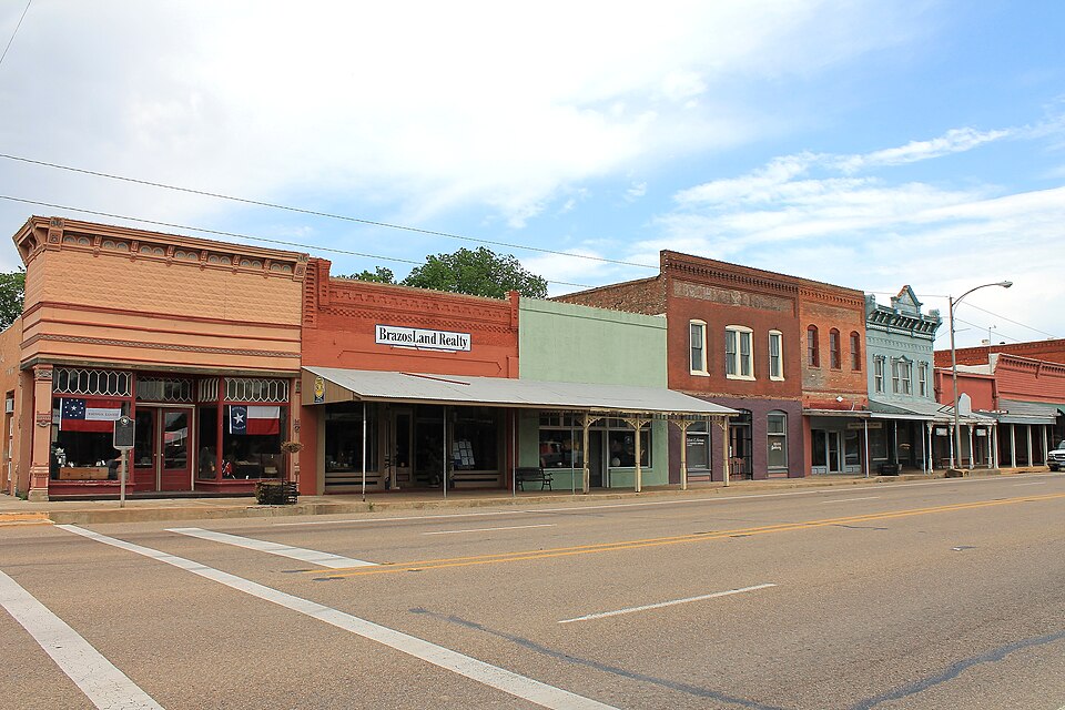
Photograph of Calvert Historic District
Photograph by Renelibrary, CC BY-SA 3.0. Via Wikimedia Commons.

Calvert Historic District

Listed on the National Register of Historic Places in 1978.

From the record

“The Calvert Historic District is a historic district which comprises 70 acres (280,000 m2) roughly bounded by Main, Garritt, Pin Oak, Maple, and Barton streets in Calvert, Texas. Contributing properties in the district consist of 82 buildings, one site and two other structures.”

Wikipedia article Calvert Historic District, CC BY-SA 4.0.

One of 5 National Register listings published here for Robertson County · listed in 1978 · category: District.

Sources: the Wikipedia article · the case file at the National Archives · the National Register database, National Park Service

The listing

Fires near this property

65 since 2005

Regional context, not property-specific evidence. The federal wildfire occurrence database lists 65 fires within 5 miles of Calvert Historic District between 2005 and 2020, burning about 1,414 acres in total. 1 started naturally. 1 was recorded as arson. Distance is straight-line from the map coordinates, so a fire counted here may appear on a neighbouring settlement's page as well.

Reported cause Fires
Debris and open burning30
Missing data/not specified/undetermined23
Railroad operations and maintenance5
Equipment and vehicle use5
Arson/incendiarism1
Natural1

The most recent of them, most recent first, with the day each was reported and the service that recorded it.

DateCause SizeReported by Name on the report
21 September 2017Debris and open burningunder an acreTexas A & M Forest ServiceHWY 6 NORTH OF MUD CREEK
19 September 2018Debris and open burning7.0 acresTexas A & M Forest ServiceW. KEZEE
15 September 2018Debris and open burning5.0 acresTexas A & M Forest ServiceTIDWELL RD.
10 September 2011Equipment and vehicle use5.0 acresTexas A & M Forest ServiceTHOMPSON RD
8 August 2017Debris and open burning1.5 acresTexas A & M Forest ServiceFM 1644
6 August 2006Missing data/not specified/undetermined15 acresTexas A & M Forest Servicenot named
5 August 2019Missing data/not specified/undetermined1.0 acresTexas A & M Forest ServiceFM 1644
4 August 2018Equipment and vehicle use3.5 acresTexas A & M Forest ServiceSOUTH TIDWELL

Every fire recorded in Robertson County

Storms near this property

21 since 1995

Regional context, not property-specific evidence. The National Weather Service names Calvert, the town this property stands in, in 21 storm reports between 1995 and 2025: 9 thunderstorm wind, 7 hail, 4 flash flood, 1 tornado. No death or injury is recorded in these reports. Each account below is quoted exactly as the forecast office filed it, from the NOAA Storm Events Database, and each date opens the federal record of that event.

WhenEvent Place namedHarm What the report says
May 2010Thunderstorm WindCalvert$30,000Numerous trees were blown down in the city of Calvert.
February 2017Thunderstorm WindCalvert$5,000Robertson County Sheriff's Department reported that the roof was blown off of a house in Calvert, TX, and that trees were reported down across the county.
May 2017Thunderstorm WindCalvert$5,000Robertson County Sheriff's Department reported roof damage in the city of Calvert, TX.
August 1995Thunderstorm WindCalvert$2,000Power lines were blown down by high winds.
June 2025Flash FloodCalvert$1,000EM reported water over the roadway at Tidwell Creek and South Main.
May 2024HailCalvert-Quarter sized hail was reported just south of Calvert via a social media picture.
April 2019Tornado (EFU)Calvert-A brief rope tornado occurred approximately 5 miles northwest of the city of Calvert, TX. The tornado was rated EF-0, lasted less than 30 seconds and produced no known damage.
November 2018HailCalvert-Broadcast media reported hail slightly larger than quarters in the city of Calvert, TX.
May 2017Thunderstorm WindCalvert-Calvert Police Department reported several trees blocking a couple of roads near the city of Calvert, TX.
May 2017HailCalvert-A social media report indicated quarter size hail in Calvert.
June 2012HailCalvert-Penny sized hail was reported north of Calvert.
May 2006Thunderstorm WindCalvert-Trees down.
October 2006Flash FloodCalvert-Streets were flooded and closed in Calvert and on FM 1644 between Calvert and Franklin.
June 2004Flash FloodCalvert-FM 1644 was barricaded due to high water.
August 2004Thunderstorm WindCalvert-4 to 6 inch diameter tree limbs were blown down in Calvert.
October 2001Thunderstorm WindCalvert-Large tree limbs were blown off trees.
October 1998Flash FloodCalvert-Farm Market Road 1640 was flooded near Calvert and in Franklin.
March 2017HailCalvert-no account filed
March 2014HailCalvert-no account filed
April 1997Thunderstorm WindCalvert-no account filed
April 1996HailCalvert-no account filed

Every storm recorded in Robertson County

Map coverage status

No historic map-sheet match is published for this property yet. That does not mean no map exists. This record needs a coordinate-quality review before it can be joined to a sheet boundary. Browse the county's mapped places while that work is pending.

Listed places nearby

1 within 8 miles

Other National Register properties close enough to walk or drive between, ordered by distance from this one. Both positions come from the same geocoding pass that matched these properties to their map sheets.

Photograph PropertyDistance Listed
Hammond Houseunder 500 feet1970

Sources for this property

National Archives recordThe nomination case file for reference 78002978 in Record Group 79.
Wikipedia articleCommunity-written account of this property, licensed CC BY-SA.
Robertson CountyAll 5 listed properties in this county.

Provenance

  • Listing record. National Park Service National Register of Historic Places, listed-properties dataset, current to 2026-05-22.
  • Map join. Address geocoded through the United States Census geocoder, then tested against the published boundary of every sheet in the USGS Historical Topographic Map Collection.
  • How this page is made. Listing fields come from federal records; map-sheet coverage is a labelled coordinate-to-boundary calculation, not a source-field claim.
  • Wildfire. Short, Karen C. 2022. Spatial wildfire occurrence data for the United States, 1992-2020 [FPA_FOD_20221014]. 6th Edition. Fort Collins, CO: Forest Service Research Data Archive. https://doi.org/10.2737/RDS-2013-0009.6 Collected with United States Government funding and usable without additional permissions or fees.
  • Storms. NOAA National Centers for Environmental Information, Storm Events Database https://www.ncei.noaa.gov/stormevents/ A work of the United States government, no copyright under 17 U.S.C. 105. Narratives are quoted verbatim from the National Weather Service report and are not edited or summarised.