 Block
BlockFrom the record
One of 74 National Register listings published here for Williamson County · listed in 1978 · category: Building.
Sources: the case file at the National Archives · the National Register database, National Park Service
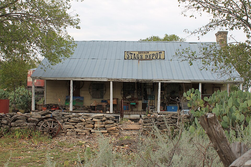
Listed on the National Register of Historic Places in 1978.
One of 74 National Register listings published here for Williamson County · listed in 1978 · category: Building.
Sources: the case file at the National Archives · the National Register database, National Park Service
Regional context, not property-specific evidence. The federal wildfire occurrence database lists 199 fires within 5 miles of Bryson Stage Coach Stop between 2004 and 2020, burning about 1,681 acres in total. 6 started naturally. 5 were recorded as arson. Distance is straight-line from the map coordinates, so a fire counted here may appear on a neighbouring settlement's page as well.
| Reported cause | Fires |
|---|---|
| Debris and open burning | 87 |
| Missing data/not specified/undetermined | 66 |
| Equipment and vehicle use | 17 |
| Power generation/transmission/distribution | 8 |
| Natural | 6 |
| Arson/incendiarism | 5 |
| Misuse of fire by a minor | 4 |
| Railroad operations and maintenance | 3 |
| Smoking | 2 |
| Recreation and ceremony | 1 |
The most recent of them, most recent first, with the day each was reported and the service that recorded it.
| Date | Cause | Size | Reported by | Name on the report |
|---|---|---|---|---|
| 8 September 2012 | Missing data/not specified/undetermined | 1.0 acres | Texas A & M Forest Service | 701 PHILLIP LANE |
| 4 September 2004 | Missing data/not specified/undetermined | 5.0 acres | Texas A & M Forest Service | not named |
| 22 September 2011 | Missing data/not specified/undetermined | 1.0 acres | Texas A & M Forest Service | 2401 DOUBLE FILE TR |
| 20 September 2015 | Equipment and vehicle use | 1.0 acres | Texas A & M Forest Service | 1103 CR 204 |
| 20 September 2011 | Missing data/not specified/undetermined | 2.0 acres | Texas A & M Forest Service | COUNTY 201 RD |
| 2 September 2011 | Missing data/not specified/undetermined | 1.0 acres | Texas A & M Forest Service | 4850 RR 1869 |
| 16 September 2014 | Missing data/not specified/undetermined | 3.0 acres | Texas A & M Forest Service | 9750 W. SH 29 |
| 14 September 2017 | Debris and open burning | 1.0 acres | Texas A & M Forest Service | 751 CR 203 |
Regional context, not property-specific evidence. The federal mineral resources record lists 2 workings within 5 miles of Bryson Stage Coach Stop: 2 producers. All of them still produce. What was taken out: Stone, Limestone, General. Distance is straight-line from the map coordinates, so a quarry counted here may appear on a neighbouring settlement's page as well.
| Where | Site | Commodity | Status | Recorded |
|---|---|---|---|---|
| Armadillo Quarry | Limestone, General | Producer | ||
| Johnson Quarry | Stone | Producer | Sedimentary |
Regional context, not property-specific evidence. The National Weather Service names Liberty Hill, the town this property stands in, in 55 storm reports between 1997 and 2025: 32 hail, 11 flash flood, 8 thunderstorm wind, 2 tornado. The reports record 1 death. Each account below is quoted exactly as the forecast office filed it, from the NOAA Storm Events Database, and each date opens the federal record of that event.
| When | Event | Place named | Harm | What the report says |
|---|---|---|---|---|
| March 2007 | Flash Flood | Liberty Hill | 1 killed | CR258, CR268, CR305 were all closed due to high water, among many others. A husband and wife were driving home in the Georgetown area near 1920 pm CST. Their vehicle stalled in high water in Berry Creek. Rescuers reached the couple and attempted to bring them to safety, both were swept downstream. The woman was successfully rescued but the man drowned. |
| May 2001 | Thunderstorm Wind | Liberty Hill | $300,000 | no account filed |
| September 2018 | Flash Flood | Liberty Hill | $200,000 | More than sixty people had to be rescued from the Casa Rio Del Colores wedding venue as a large wedding party got trapped from quickly rising waters along the South Fork of the San Gabriel River just south of Liberty Hill. Multiple cars were flooded and inundated. |
| October 2004 | Flash Flood | Liberty Hill | $100,000 | Slow-moving showers and thunderstorms dropped between 2 and 3 inches of rain in southwest Williamson County in the late evening period. Maximum totals were 5 to 6 inches between Leander and Cedar Park, closing most low water crossings due to flash flooding. Several high water rescues were made between the two cities. Newspapers reported several cars cut off and stranded by water up to 6 feet deep and rising on FM2243 just northeast of Leander. |
| March 2022 | Thunderstorm Wind | Liberty Hill | $10,000 | A thunderstorm produced wind gusts estimated at 65 mph that damaged a mall sign at the Liberty Hill Plaza. |
| August 2009 | Thunderstorm Wind | Liberty Hill | $8,000 | Thunderstorm wind gusts, estimated at 50 knots, knocked down numerous trees near the intersection of Highways 285 and 1869. |
| June 2019 | Tornado (EF0) | Liberty Hill | $5,000 | A small tornado touched down near County Road 287 southwest of Liberty Hill. Numerous trees were damaged in the three quarters of a mile path. Winds are estimated to have been near 75 mph. |
| June 2003 | Thunderstorm Wind | Liberty Hill | $5,000 | Severe thunderstorm wind gusts to 50 knots were measured at the Liberty Hill Middle School by the School Weather Network. No damage was indicated. |
| July 1997 | Thunderstorm Wind | Liberty Hill | $3,000 | Public reports high winds causing damage to trees. |
| April 2020 | Thunderstorm Wind | Liberty Hill | $2,000 | A thunderstorm produced wind gusts estimated at 60 mph that damaged some trees in Liberty Hill. |
| August 2009 | Thunderstorm Wind | Liberty Hill | $2,000 | A thunderstorm produced heavy rain and wind gusts, estimated at 45 knots, that knocked over highway signs. |
| May 2025 | Hail | Liberty Hill | - | A thunderstorm produced penny size hail northwest of Liberty Hill. |
| May 2025 | Hail | Liberty Hill | - | A thunderstorm produced pea to quarter size hail northwest of Liberty Hill. |
| May 2025 | Hail | Liberty Hill | - | A thunderstorm produced quarter size hail west of Liberty Hill. |
| May 2025 | Hail | Liberty Hill | - | A thunderstorm produced half dollar size hail in Liberty Hill. |
| May 2025 | Hail | Liberty Hill | - | A thunderstorm produced half dollar size hail south of Liberty Hill. |
| May 2025 | Hail | Liberty Hill | - | A thunderstorm produced half dollar size hail south of Liberty Hill. |
| May 2025 | Hail | Liberty Hill | - | A thunderstorm produced ping pong ball size hail southwest of Liberty Hill. |
| May 2025 | Hail | Liberty Hill | - | A thunderstorm produced golf ball size hail south of Liberty Hill. |
| July 2025 | Flash Flood | Liberty Hill | - | Thunderstorms produced 8-10 inches of rain over the headwaters of the San Gabriel River in Burnet County and an additional 1-2 inches over Liberty Hill. This caused flash flooding.|Law Enforcement reported several large sheds and storage buildings moved off of their foundations and sitting along the side of Hwy 29 in Liberty Hill. |
| July 2025 | Flash Flood | Liberty Hill | - | Thunderstorms produced 8-10 inches of rain over the headwaters of the San Gabriel River in Burnet County and an additional 1-2 inches over Liberty Hill. Liberty Hill PD reported that CR 279 is underwater, and the bridge over the South Fork San Gabriel River had several feet of water over it. Flood waters were up 15 to 20 ft high. |
| July 2025 | Flash Flood | Liberty Hill | - | Thunderstorms produced 8-10 inches of rain over the headwaters of the San Gabriel River in Burnet County and an additional 1-2 inches over Liberty Hill. First responders performed a water rescue on CR 285, southwest of Liberty Hill. Water was going through first story windows of a house. |
| April 2024 | Hail | Liberty Hill | - | A thunderstorm produced half dollar size hail south of Liberty Hill. |
| April 2023 | Hail | Liberty Hill | - | A thunderstorm produced quarter size hail north of Liberty Hill. |
| April 2023 | Hail | Liberty Hill | - | A thunderstorm produced quarter size hail south of Liberty Hill. |
| April 2023 | Hail | Liberty Hill | - | A thunderstorm produced ping pong ball size hail east of Liberty Hill. |
| April 2023 | Hail | Liberty Hill | - | A thunderstorm produced quarter size hail north of Liberty Hill. |
| April 2023 | Hail | Liberty Hill | - | A thunderstorm produced half dollar size hail in Liberty Hill. |
| June 2023 | Hail | Liberty Hill | - | A thunderstorm produced half dollar size hail south of Liberty Hill. |
| May 2022 | Hail | Liberty Hill | - | A thunderstorm produced nickel size hail on Hwy 29 near Liberty Hill. |
| April 2021 | Hail | Liberty Hill | - | A thunderstorm produced half dollar size hail and covered the ground with hail. |
| April 2021 | Hail | Liberty Hill | - | A thunderstorm produced ping pong ball size east of Liberty Hill. |
| January 2020 | Hail | Liberty Hill | - | A thunderstorm produced pea to nickel size hail north of Liberty Hill. |
| May 2017 | Hail | Liberty Hill | - | A thunderstorm produced hail up to quarter size in Liberty Hill. |
| May 2015 | Tornado (EF1) | Liberty Hill | - | A NWS storm survey team found an EF-1 tornado initially touched down near County Road 201 just west of County Road 200. The tornado traveled to the north-northeast through the Indian Oaks and Carriage Oaks subdivisions before crossing County Road 200 and lifting near East Bear Creek Rd. Damage was primarily to large oak trees, but about 7 to 10 homes suffered damage mainly to roofs. The most substantial damage was a complete loss of a chimney. Also, a barn lost part of its roof. Peak winds were estimated at 100 mph. |
| May 2015 | Flash Flood | Liberty Hill | - | Several low water crossings were reported closed across western Williamson County. |
| May 2015 | Flood | Liberty Hill | - | Several low water crossings remained closed several hours after rain ended in the county. Water continued to flow over the roadways across western Williamson County. |
| May 2015 | Flash Flood | Liberty Hill | - | Thunderstorms produced heavy rain that caused flash flooding. A number of homes were evacuated due to flooding in Liberty Hill near FM 1869 and CR 279. Numerous roads were closed including CR 282, CR 279, and Hwy 29 at US 183. |
| May 2015 | Thunderstorm Wind | Liberty Hill | - | A thunderstorm produced wind gusts estimated at 70 mph uprooted some large Oak trees and damaged a mobile home and the roofs of several houses. |
| September 2012 | Flash Flood | Liberty Hill | - | Thunderstorms produced heavy rain that caused flash flooding closing County Road 279 north of County Road 281. |
| September 2009 | Hail | Liberty Hill | - | A thunderstorm dropped pea to penny size hail for 10 minutes. |
| February 2009 | Hail | Liberty Hill | - | One of the broadcast media relayed a report from the Williamson County EMS of penny size hail near the intersection of County Rds. 201 and 206. |
| May 2007 | Flash Flood | Liberty Hill | - | Scattered showers and thunderstorms produced general 3 to 4 inch rain amounts between Liberty Hill and Round Rock. Spotters reported 2 feet of water over SH29. |
| July 2007 | Flash Flood | Liberty Hill | - | Thunderstorms in southern Williamson County produced between 2 and 3 inches of rain, closing CR214, and CR100, along with several roads in Georgetown. |
| May 2017 | Hail | Liberty Hill | - | no account filed |
| March 2013 | Hail | Liberty Hill | - | no account filed |
| October 2009 | Hail | Liberty Hill | - | no account filed |
| April 2008 | Hail | Liberty Hill | - | no account filed |
| May 2007 | Hail | Liberty Hill | - | no account filed |
| April 2006 | Hail | Liberty Hill | - | no account filed |
| March 2005 | Hail | Liberty Hill | - | no account filed |
| November 2004 | Funnel Cloud | Liberty Hill | - | no account filed |
| May 2000 | Hail | Liberty Hill | - | no account filed |
| March 1999 | Hail | Liberty Hill | - | no account filed |
| July 1997 | Hail | Liberty Hill | - | no account filed |
No historic map-sheet match is published for this property yet. That does not mean no map exists. This record needs a coordinate-quality review before it can be joined to a sheet boundary. Browse the county's mapped places while that work is pending.
| National Archives record | The nomination case file for reference 78003000 in Record Group 79. |
| Williamson County | All 74 listed properties in this county. |