 Block
BlockFrom the record
One of 6 National Register listings published here for Culberson County · listed in 1979 · category: Building.
Sources: the case file at the National Archives · the National Register database, National Park Service
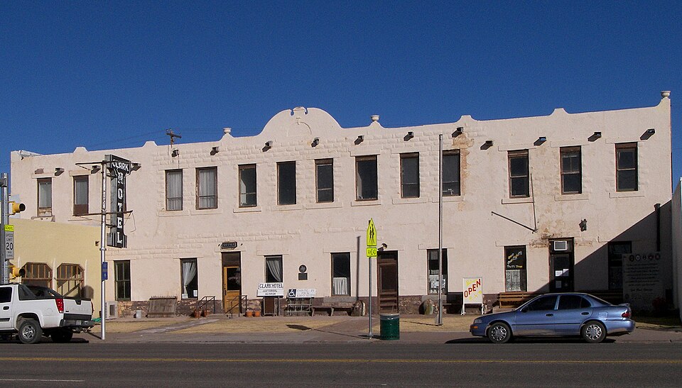
Listed on the National Register of Historic Places in 1979.
One of 6 National Register listings published here for Culberson County · listed in 1979 · category: Building.
Sources: the case file at the National Archives · the National Register database, National Park Service
Regional context, not property-specific evidence. The federal mineral resources record lists 11 workings within 5 miles of Clark Hotel: 8 occurrences, 2 producers, 1 prospect. 2 still produce. What was taken out: Copper, Silver, Silver, Copper, Talc-Soapstone, Barium-Barite. Distance is straight-line from the map coordinates, so a quarry counted here may appear on a neighbouring settlement's page as well.
| Where | Site | Commodity | Status | Recorded |
|---|---|---|---|---|
| Mcvay Ranch Pit | Sand and Gravel, Construction | Producer | Gravel, Sand | |
| Neal Mann Prospect | Talc-Soapstone, Asbestos | Occurrence | Metamorphic | |
| Neal Mann Prospect | Talc-Soapstone | Prospect | ||
| Tumbledown Quarry | Talc-Soapstone | Producer | ||
| Unnamed Occurrence | Barium-Barite | Occurrence | Vein | |
| Unnamed Prospect | Silver, Copper | Occurrence | ||
| Unnamed Prospect | Silver, Copper | Occurrence | ||
| Unnamed Prospect | Barium-Barite | Occurrence | Vein | |
| Unnamed Prospect | Copper, Silver | Occurrence | ||
| Unnamed Prospect | Copper, Silver | Occurrence |
Regional context, not property-specific evidence. The National Weather Service names Van Horn, the town this property stands in, in 21 storm reports between 1996 and 2023: 9 hail, 8 thunderstorm wind, 2 flash flood, 1 tornado. The reports record 1 injury. Each account below is quoted exactly as the forecast office filed it, from the NOAA Storm Events Database, and each date opens the federal record of that event.
| When | Event | Place named | Harm | What the report says |
|---|---|---|---|---|
| July 1996 | Thunderstorm Wind | Van Horn | 1 hurt, $50,000 | no account filed |
| May 2023 | Thunderstorm Wind | Van Horn | $50,000 | Culberson County emergency manager reported a power outage in Van Horn with roof damage to the Knights Inn. Photos showed part of the roof peeled up and ripped off of the motel with damage to nearby vehicles and powerlines. Damage was likely caused by a localized dry microburst based on satellite data. Wind speeds are estimated to have been between 60-70 mph. Property damage costs are a rough estimate. |
| July 2018 | Thunderstorm Wind | Van Horn | $30,000 | A thunderstorm moved across Culberson County and produced wind damage in Van Horn. A large tin roof was blown off of a building and onto a highway. There was other wind damage around town such as fences and power lines blown down. The damage was likely caused by a microburst. The cost of damage is a very rough estimate. |
| August 2020 | Thunderstorm Wind | Van Horn | $20,000 | A thunderstorm that moved across Van Horn produced a localized area of damaging straight-line winds as the core of this storm collapsed just south of the town. Culberson County Office of Emergency Management reported ten snapped powerline poles one to two miles south of Van Horn along Highway 90 that resulted in a town-wide power outage. It was determined by the National Weather Service that the damage was caused by a microburst after re-evaluating radar data and assessing the damage remotely using photos sent in by the Culberson County emergency management. Winds were estimated to be near 100 mph. The cost of damage is a very rough estimate. |
| September 2006 | Flash Flood | Van Horn | $10,000 | Texas Highway 54 was closed from Van Horn to Pine Springs on August 31st due to damage from flooding. Attempts to fix the highway failed on September 1st when additional rainfall washed out repairs. |
| June 2014 | Thunderstorm Wind | Van Horn | $2,500 | A thunderstorm moved across Culberson County and produced wind damage in Van Horn. There was wind damage to a barn shed and a garage shop roof was blown off. The cost of damage is a very rough estimate. |
| July 2022 | Thunderstorm Wind | Van Horn | - | A thunderstorm produced a 59 mph wind gust at the Mesonet site near Van Horn. |
| March 2019 | Thunderstorm Wind | Van Horn | - | A thunderstorm moved across Culberson County and produced a 59 mph wind gust near Van Horn. |
| August 2015 | Thunderstorm Wind | Van Horn | - | A storm moved across Culberson County and produced a 60 mph wind gust north of Van Horn as measured by the local ASOS site. |
| April 2013 | Hail | Van Horn | - | A thunderstorm developed over Culberson County and produced penny sized hail in Van Horn. |
| May 2005 | Hail | Van Horn | - | Strong to severe convection developed along the higher terrain of far west Texas and extreme northern Mexico during the afternoon of the 5th. An isolated supercell thunderstorm tracked east across southern Culberson County during the evening hours. Large hail accumulated along U.S. Highway 90 south of Van Horn. The Texas Department of Transportation reported hail remained and continued to cover grassy areas at 08:00 CST on the morning of the 6th, some twelve hours after the storm. |
| September 2004 | Flash Flood | Van Horn | - | At 10:41 CST National Park Service employees reported flash flooding that resulted in high water over Texas Highway 54 at several locations between Van Horn and Pine Springs. A later report from the National Park Service indicated that the water was flowing up to two feet deep at some locations by 15:15 CST. Heavy rainfall exited Culberson County by late afternoon. The flash flooding quickly receded along Texas Highway 54, but debris was reported covering portions of the highway, where flooding had occurred at 17:30 CST. |
| June 2002 | Hail | Van Horn | - | A severe thunderstorm developed over Culberson County just after midnight local time...resulting in nickel size hail in the city of Van Horn. |
| August 2002 | Tornado (F0) | Van Horn | - | A DPS trooper traveling on Interstate 10 reported a "long and skinny" tornado east of Van Horn. Radar indicated a strong thunderstorm in the area with cloud tops to 50,000 feet. |
| August 2002 | Flood | Van Horn | - | Law officials reported flooding of low lying areas along Interstate 10 east of Van Horn. |
| October 1998 | Hail | Van Horn | - | This storm entered southern Culberson County from extreme southern Hudspeth County. Golfball size hail fell on U.S. Highway 90 south of Van Horn. |
| June 2023 | Hail | Van Horn | - | no account filed |
| June 2018 | Hail | Van Horn | - | no account filed |
| April 2017 | Hail | Van Horn | - | no account filed |
| June 2014 | Hail | Van Horn | - | no account filed |
| September 2007 | Hail | Van Horn | - | no account filed |
No historic map-sheet match is published for this property yet. That does not mean no map exists. This record needs a coordinate-quality review before it can be joined to a sheet boundary. Browse the county's mapped places while that work is pending.
Other National Register properties close enough to walk or drive between, ordered by distance from this one. Both positions come from the same geocoding pass that matched these properties to their map sheets.
| Photograph | Property | Distance | Listed |
|---|---|---|---|
 | First Presbyterian Church | 0.2 miles | 1978 |
| National Archives record | The nomination case file for reference 79002929 in Record Group 79. |
| Culberson County | All 6 listed properties in this county. |