
BlockBefore
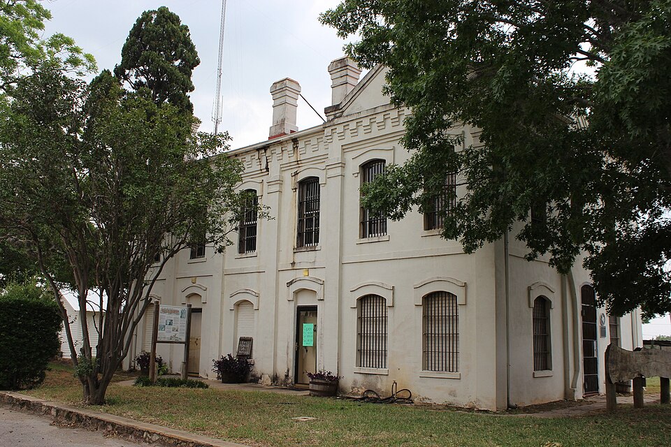
Photograph of Old Frio County Jail
Photograph by Darrylpearson, CC BY-SA 4.0. Via Wikimedia Commons.

Old Frio County Jail

Listed on the National Register of Historic Places in 1979.

From the record

“The Old Frio County Jail, in Pearsall, Texas, was built in 1884. It was listed on the National Register of Historic Places in 1979.”

Wikipedia article Old Frio County Jail, CC BY-SA 4.0.

One of 1 National Register listings published here for Frio County · listed in 1979 · category: Building.

Sources: the Wikipedia article · the case file at the National Archives · the National Register database, National Park Service

The listing

  • What is counted as historic. The nomination lists 1 building as contributing to the listing.
  • Address. E. Medina and S. Pecan Sts., Pearsall, 78061
  • When was it listed? November 1979
  • Category. building
  • Census division. Pearsall
  • Architectural style. Victorian architecture
  • National Register reference number. 79002941 - the number the National Park Service assigned this property when it was listed, and the key its nomination file is catalogued under at the National Archives.

Fires near this property

304 since 2005

Regional context, not property-specific evidence. The federal wildfire occurrence database lists 304 fires within 5 miles of Old Frio County Jail between 2005 and 2020, burning about 1,484 acres in total. 1 started naturally. 6 were recorded as arson. Distance is straight-line from the map coordinates, so a fire counted here may appear on a neighbouring settlement's page as well.

Reported cause Fires
Missing data/not specified/undetermined132
Debris and open burning60
Equipment and vehicle use55
Misuse of fire by a minor19
Smoking14
Power generation/transmission/distribution11
Arson/incendiarism6
Recreation and ceremony4
Railroad operations and maintenance2
Natural1

The most recent of them, most recent first, with the day each was reported and the service that recorded it.

DateCause SizeReported by Name on the report
7 September 2019Debris and open burningunder an acreTexas A & M Forest Service1105 W. COLORADO
6 September 2012Equipment and vehicle useunder an acreTexas A & M Forest ServiceIH 35 MM 102
5 September 2015Missing data/not specified/undeterminedunder an acreTexas A & M Forest ServiceIH 35 MM 99
5 September 2005Debris and open burning15 acresTexas A & M Forest Servicenot named
4 September 2015Smokingunder an acreTexas A & M Forest ServiceIH 35 MM 104
4 September 2011Missing data/not specified/undeterminedunder an acreTexas A & M Forest ServiceHWY 1581 & CR4201
30 September 2015Railroad operations and maintenanceunder an acreTexas A & M Forest Service100 BLK S ELM
30 September 2015Debris and open burning8.0 acresTexas A & M Forest Service5150 FM 2779

Every fire recorded in Frio County

Mines and quarries near this property

1 within 5 miles

Regional context, not property-specific evidence. The federal mineral resources record lists 1 working within 5 miles of Old Frio County Jail: 1 past producer. None of them still produces. What was taken out: Sand and Gravel, Construction. Distance is straight-line from the map coordinates, so a quarry counted here may appear on a neighbouring settlement's page as well.

Where SiteCommodity StatusRecorded
Pearsall MineSand and Gravel, ConstructionPast Producer

Every working recorded in Frio County

Storms near this property

52 since 1994

Regional context, not property-specific evidence. The National Weather Service names Pearsall, the town this property stands in, in 52 storm reports between 1994 and 2024: 33 hail, 9 thunderstorm wind, 9 flash flood, 1 tornado. No death or injury is recorded in these reports. Each account below is quoted exactly as the forecast office filed it, from the NOAA Storm Events Database, and each date opens the federal record of that event.

WhenEvent Place namedHarm What the report says
March 1994HailPearsall$50,000A thunderstorm formed in the late evening just west of Dilley and moved northeastward near 35 mph. It produced golf ball-sized hail as it reached Pearsall near 2125 CST. Little damage was indicated.
May 1999Thunderstorm WindPearsall$50,000no account filed
March 1998Thunderstorm WindPearsall$25,000no account filed
March 1997Thunderstorm WindPearsall$20,000no account filed
May 2013Thunderstorm WindPearsall$10,000A thunderstorm produced wind gusts estimated at 60 mph that broke or knocked out numerous west facing windows on houses, RVs, and other vehicles.
May 1997Thunderstorm WindPearsall$10,000Department of Public Safety personnel reported power lines down in Pearsall.
March 1994HailPearsall$5,000A severe thunderstorm produced golf ball-size hail at Pearsall as it moved through Frio County late in the evening.
March 1997HailPearsall$5,000no account filed
June 1999Flash FloodPearsall$3,000no account filed
March 2012HailPearsall$2,000A thunderstorm produced golf ball size hail which damaged a pickup truck on FM1582 near Pearsall.
January 2024HailPearsall-A thunderstorm produced nickel size hail near the intersection of FM 140 and I-35 in Pearsall.
March 2018HailPearsall-A thunderstorm produced quarter size hail near the Petro Shopping Center west of I-35 in Pearsall.
March 2018HailPearsall-A thunderstorm produced quarter size hail near N. Cherry St. in Pearsall.
March 2018HailPearsall-A thunderstorm produced 1.5 inch hail on the north side of Pearsall. There was also some tree branch damage at this location.
June 2016Flash FloodPearsall-Thunderstorms produced heavy rain that caused flash flooding closing several streets in Pearsall.
April 2014HailPearsall-Quarter and ping pong ball sized hail.
April 2010Flash FloodPearsall-Slow moving thunderstorms produced heavy rain and flooding closing some rural roads around Pearsall.
September 2009Flash FloodPearsall-Heavy rain caused flooding which closed FM 140 from Frio Town to Pearsall to the Atascosa County line.
March 2009Thunderstorm WindPearsall-There was an eight inch diameter tree branch blown down.
May 2008HailPearsall-Hail was reported near the intersection of FM 140 and I-35.
July 2007Flash FloodPearsall-A second round of storms produced an additional 3 inches of rain just east of Pearsall, redeveloping the flash flooding from earlier that morning. FM2779 and FM140 were reported to be under water.
March 2007Flash FloodPearsall-The northern half of Frio County received 2 to 3 inches of rain in general, with up to 5 inches near Big Foot. Flash flooding closed FM462 and FM472.
July 2007Flash FloodPearsall-Thunderstorms in Frio County produced general 2 to 3 inch rains over already saturated soils. This re-developed flash flooding very quickly between Pearsall and Derby. FM1581 and FM1582 were closed due to the flooding.
July 2007Flash FloodPearsall-A cluster of thunderstorms stretching from near Pearsall in Frio County across southern Bexar County and northern Atascosa County, through Seguin and Stockdale to Gonzales produced general 2 to 3 inch rain totals and spotty flash flooding problems. Highest rain amounts in Frio County were 6 inches southeast of Pearsall, where FM1582 and FM140 were closed due to high water.
May 2007Flash FloodPearsall-Scattered showers and thunderstorms produced general 1 to 3 inch rain amounts in southeast Frio County and southwest Atascosa County with isolated totals to 5 inches. Flash flooding closed SH85.
March 1999Tornado (F1)Pearsall-The same chaser who viewed the tornado just southeast of Batesville, observed a second tornado as it developed over open country near Pearsall. This one lived for approximately three minutes, then became rain-wrapped and dissipated.
June 1995Thunderstorm WindPearsall-Gusts estimated over 55 knots caused widespread tree and limb damage.
February 2016HailPearsall-no account filed
April 2016HailPearsall-no account filed
March 2016HailPearsall-no account filed
April 2015HailPearsall-no account filed
April 2014HailPearsall-no account filed
May 2013HailPearsall-no account filed
March 2013HailPearsall-no account filed
May 2009HailPearsall-no account filed
March 2009HailPearsall-no account filed
November 2004HailPearsall-no account filed
March 2002HailPearsall-no account filed
March 1998HailPearsall-no account filed
May 1997HailPearsall-no account filed
May 1996HailPearsall-no account filed
April 1996HailPearsall-no account filed

Every storm recorded in Frio County

Map coverage status

No historic map-sheet match is published for this property yet. That does not mean no map exists. This record needs a coordinate-quality review before it can be joined to a sheet boundary. Browse the county's mapped places while that work is pending.

Sources for this property

National Archives recordThe nomination case file for reference 79002941 in Record Group 79.
Wikipedia articleCommunity-written account of this property, licensed CC BY-SA.
Frio CountyAll 1 listed properties in this county.

Provenance

  • Listing record. National Park Service National Register of Historic Places, listed-properties dataset, current to 2026-05-22.
  • Map join. Address geocoded through the United States Census geocoder, then tested against the published boundary of every sheet in the USGS Historical Topographic Map Collection.
  • How this page is made. Listing fields come from federal records; map-sheet coverage is a labelled coordinate-to-boundary calculation, not a source-field claim.
  • Wildfire. Short, Karen C. 2022. Spatial wildfire occurrence data for the United States, 1992-2020 [FPA_FOD_20221014]. 6th Edition. Fort Collins, CO: Forest Service Research Data Archive. https://doi.org/10.2737/RDS-2013-0009.6 Collected with United States Government funding and usable without additional permissions or fees.
  • Mines and quarries. USGS Mineral Resources Data System (MRDS) https://mrdata.usgs.gov/mrds/ A work of the United States government, no copyright under 17 U.S.C. 105.
  • Storms. NOAA National Centers for Environmental Information, Storm Events Database https://www.ncei.noaa.gov/stormevents/ A work of the United States government, no copyright under 17 U.S.C. 105. Narratives are quoted verbatim from the National Weather Service report and are not edited or summarised.