 Block
BlockFrom the record
One of 5 National Register listings published here for Kerr County · listed in 1982 · category: Building.
Sources: the case file at the National Archives · the National Register database, National Park Service
Listed on the National Register of Historic Places in 1982.
One of 5 National Register listings published here for Kerr County · listed in 1982 · category: Building.
Sources: the case file at the National Archives · the National Register database, National Park Service
Regional context, not property-specific evidence. The federal wildfire occurrence database lists 69 fires within 5 miles of Tulahteka between 2000 and 2018, burning about 1,552 acres in total. None started naturally. None was recorded as arson. Distance is straight-line from the map coordinates, so a fire counted here may appear on a neighbouring settlement's page as well.
| Reported cause | Fires |
|---|---|
| Debris and open burning | 36 |
| Missing data/not specified/undetermined | 27 |
| Recreation and ceremony | 2 |
| Smoking | 1 |
| Power generation/transmission/distribution | 1 |
| Misuse of fire by a minor | 1 |
| Equipment and vehicle use | 1 |
The most recent of them, most recent first, with the day each was reported and the service that recorded it.
| Date | Cause | Size | Reported by | Name on the report |
|---|---|---|---|---|
| 4 September 2000 | Missing data/not specified/undetermined | 1,200 acres | Texas A & M Forest Service | HORIZON |
| 25 September 2008 | Debris and open burning | 50 acres | Texas A & M Forest Service | not named |
| 20 September 2008 | Missing data/not specified/undetermined | under an acre | Texas A & M Forest Service | not named |
| 20 September 2008 | Missing data/not specified/undetermined | 1.0 acres | Texas A & M Forest Service | not named |
| 30 August 2007 | Debris and open burning | 1.0 acres | Texas A & M Forest Service | not named |
| 20 August 2008 | Debris and open burning | 1.5 acres | Texas A & M Forest Service | not named |
| 2 August 2010 | Debris and open burning | 1.0 acres | Texas A & M Forest Service | 240KAMIRA-FIRE |
| 14 August 2008 | Debris and open burning | under an acre | Texas A & M Forest Service | not named |
Regional context, not property-specific evidence. The federal mineral resources record lists 2 workings within 5 miles of Tulahteka: 2 producers. All of them still produce. What was taken out: Sand and Gravel, Construction. Distance is straight-line from the map coordinates, so a quarry counted here may appear on a neighbouring settlement's page as well.
| Where | Site | Commodity | Status | Recorded |
|---|---|---|---|---|
| Ingram Pit | Sand and Gravel, Construction | Producer | ||
| Sand Pit | Sand and Gravel, Construction | Producer |
Regional context, not property-specific evidence. The National Weather Service names Kerrville, the town this property stands in, in 85 storm reports between 1993 and 2025: 61 hail, 14 thunderstorm wind, 8 flash flood, 1 tornado. No death or injury is recorded in these reports. Each account below is quoted exactly as the forecast office filed it, from the NOAA Storm Events Database, and each date opens the federal record of that event.
| When | Event | Place named | Harm | What the report says |
|---|---|---|---|---|
| May 2020 | Thunderstorm Wind | Kerrville | $1,000,000 | An NWS damage survey concluded a microburst hit the city of Kerrville at approximately 8:00-8:10 PM CDT. The highest estimated wind speeds of 70-80 mph occurred on the west side of Kerrville just up the hill from Peterson Hospital on Rimrock Rd. There was roof damage to several homes on Rimrock Rd. where the backyards faced west and wind came up the hill and took off porches and roofs. Throughout that neighborhood there was substantial tree damage, many of the trees snapped or uprooted. The swatch of significant wind damage was well over one mile wide and continued southeast into the area off Ranchero Rd. Hail accompanied the strong microburst as evident by trees stripped of leaves and piles of hail still on the ground nearly 24 hours later. The microburst and wind damage was also seen farther southeast between Hwy 16 and Hwy 689 in a neighborhood just west of Kerrville-Schreiner Park. Other wind damage was reported across the city of Kerrville but was not as significant. Estimates of damage are placed near 1 million dollars from the multiple homes that were damaged by the wind, roof and shingle damage from the wind and hail, and the downing of hundreds of trees that were blown down or damaged. |
| October 2001 | Thunderstorm Wind | Kerrville | $500,000 | Severe thunderstorm winds caused widespread damage in and around the city of Kerrville. Five aircraft were also damaged or destroyed at the Kerrville Airport. |
| June 1994 | Tornado (F0) | Kerrville | $50,000 | Residents of Kerrville reported a dark green color to the clouds as the thunderstorm approached. The storm produced a small tornado that was very short-lived. No significant damage was attributed to the tornado. However, gusts from the thunderstorm estimated at over 70 mph blew over numerous trees and damaged roofs. The worst damage occurred in the east part of Kerrville, near Shreiner College. Over 20 large trees were felled at the school, with another 30 severely damaged. The metal roof of the library was peeled back. Wind-blown debris broke windows and damaged walls of the library. The storm also blew down several power lines, knocking out power to near 12,000 homes. Six of the 7 public utility substations were damaged by the storm. Hail damage was generally confined to roofs and windows of homes and windows of automobiles. |
| June 1994 | Hail | Kerrville | $50,000 | Residents of Kerrville reported a dark green color to the clouds as the thunderstorm approached. The storm produced a small tornado that was very short-lived. No significant damage was attributed to the tornado. However, gusts from the thunderstorm estimated at over 70 mph blew over numerous trees and damaged roofs. The worst damage occurred in the east part of Kerrville, near Shreiner College. Over 20 large trees were felled at the school, with another 30 severely damaged. The metal roof of the library was peeled back. Wind-blown debris broke windows and damaged walls of the library. The storm also blew down several power lines, knocking out power to near 12,000 homes. Six of the 7 public utility substations were damaged by the storm. Hail damage was generally confined to roofs and windows of homes and windows of automobiles. |
| March 1993 | Thunderstorm Wind | Kerrville | $50,000 | Thunderstorm winds heavily damaged a large sign at the Mall and knocked down a few power lines in the area. |
| June 1996 | Thunderstorm Wind | Kerrville | $50,000 | no account filed |
| June 2003 | Thunderstorm Wind | Kerrville | $30,000 | The Kerrville Fire Department reported that severe thunderstorm winds blew down several trees and a many large limbs in the Kerrville area. |
| June 2002 | Flash Flood | Kerrville | $10,000 | Amateur radio operators reported nearly 2 inches of rain falling in less than 30 minutes in the Kerrville area. As a result, low water crossings were flooded for almost two hours. |
| May 2000 | Flash Flood | Kerrville | $10,000 | Rainfall accumulations in the Kerrville area of nearly 3 inches in one hour caused very brief flash flooding in the city. |
| November 1994 | Hail | Kerrville | $5,000 | Reported by the police department. |
| June 1994 | Hail | Kerrville | $5,000 | Residents of Kerrville reported a dark green color to the clouds as the thunderstorm approached. The storm produced a small tornado that was very short-lived. No significant damage was attributed to the tornado. However, gusts from the thunderstorm estimated at over 70 mph blew over numerous trees and damaged roofs. The worst damage occurred in the east part of Kerrville, near Shreiner College. Over 20 large trees were felled at the school, with another 30 severely damaged. The metal roof of the library was peeled back. Wind-blown debris broke windows and damaged walls of the library. The storm also blew down several power lines, knocking out power to near 12,000 homes. Six of the 7 public utility substations were damaged by the storm. Hail damage was generally confined to roofs and windows of homes and windows of automobiles. |
| July 2022 | Thunderstorm Wind | Kerrville | $2,000 | A thunderstorm produced wind gusts estimated at 60 mph that knocked down a tree on Harper Rd. in Kerrville. |
| May 2020 | Thunderstorm Wind | Kerrville | $2,000 | A thunderstorm produced wind gusts estimated at 60 mph that knocked down numerous tree limbs in Kerrville. |
| June 2019 | Thunderstorm Wind | Kerrville | $2,000 | A thunderstorm produced wind gusts estimated at 70 mph that downed trees northeast of Kerrville. |
| June 2010 | Thunderstorm Wind | Kerrville | $2,000 | A thunderstorm produced wind gusts estimated at 50 mph which knocked down Oak limbs six inches in diameter and some other trees were uprooted. |
| May 2011 | Thunderstorm Wind | Kerrville | $1,000 | A thunderstorm produced wind gusts estimated at 45 knots which knocked down small tree limbs. |
| March 2025 | Hail | Kerrville | - | A thunderstorm produced baseball size hail near Methodist Encampment Rd. in Kerrville. |
| March 2025 | Hail | Kerrville | - | A thunderstorm produced golf ball size hail in Kerrville near I-10 and Harper Rd. |
| March 2025 | Hail | Kerrville | - | A thunderstorm produced 2.5 diameter hail in Kerrville. |
| March 2025 | Hail | Kerrville | - | A thunderstorm produced two inch diameter hail in Kerrville. |
| May 2025 | Hail | Kerrville | - | A thunderstorm produced quarter size hail northwest of Comfort. |
| May 2025 | Hail | Kerrville | - | A thunderstorm produced ping pong ball size hail northwest of Comfort. |
| May 2025 | Hail | Kerrville | - | A thunderstorm produced chicken egg size hail northwest of Comfort. |
| July 2025 | Flash Flood | Kerrville | - | Thunderstorms produced heavy rain leading to flash flooding. Town Creek overflowed on Town Creek Rd in Kerrville. |
| May 2024 | Hail | Kerrville | - | A thunderstorm produced quarter size hail in Kerrville. |
| April 2023 | Hail | Kerrville | - | A thunderstorm produced hail up to quarter size northwest of Comfort in northeastern Kerr County. |
| April 2023 | Hail | Kerrville | - | A thunderstorm produced penny size hail in Kerrville. |
| June 2023 | Hail | Kerrville | - | A thunderstorm produced half dollar size hail in Kerrville. |
| June 2023 | Hail | Kerrville | - | A thunderstorm produced hail up to two inches in diameter in Kerrville. There were numerous golf ball size hailstones. |
| April 2021 | Hail | Kerrville | - | A thunderstorm produced ping pong ball size hail in Kerrville. |
| March 2021 | Hail | Kerrville | - | A thunderstorm produced quarter size hail north of Kerrville. |
| May 2021 | Hail | Kerrville | - | A thunderstorm produced quarter size hail in Kerrville. |
| May 2020 | Hail | Kerrville | - | A thunderstorm produced quarter size hail in northern Kerrville. |
| May 2020 | Hail | Kerrville | - | A thunderstorm produced quarter size hail in Kerrville. Hail covered the ground. |
| May 2020 | Hail | Kerrville | - | A thunderstorm produced ping pong ball size hail north of Kerrville. We could hear the hail hitting the roof during the phone call and the caller described the hail as the size of large marshmallows. |
| June 2019 | Hail | Kerrville | - | A thunderstorm produced 1.5 inch hail in Kerrville. |
| June 2019 | Hail | Kerrville | - | A thunderstorm produced quarter size hail in Kerrville. |
| May 2019 | Hail | Kerrville | - | A thunderstorm produced quarter size hail in Kerrville. |
| June 2016 | Hail | Kerrville | - | A thunderstorm produced hail up to quarter size that nearly covered the ground in Kerrville. |
| May 2016 | Hail | Kerrville | - | A thunderstorm produced two inch hail at the state hospital in Kerrville. |
| May 2016 | Hail | Kerrville | - | A thunderstorm produced golf ball size hail at the Schreiner Golf Course in Kerrville. |
| May 2016 | Flash Flood | Kerrville | - | Thunderstorms produced heavy rain that caused flash flooding closing several roads near Kerrville along Goat and Cypress Creeks. |
| April 2015 | Thunderstorm Wind | Kerrville | - | A thunderstorm produced wind gusts estimated at 60 mph that blew down a large tree in Kerrville. |
| March 2012 | Flash Flood | Kerrville | - | Thunderstorms produced heavy rain that caused flash flooding of low water crossings and closed FM1338 from Highway 27 north to the Gillespie County line. |
| May 2012 | Flash Flood | Kerrville | - | Thunderstorms produced heavy rain that flooded low water crossings closing Hill Country Dr. |
| July 2012 | Thunderstorm Wind | Kerrville | - | A thunderstorm produced wind gusts estimated at 58 mph that knocked down several trees in Kerrville. |
| May 2007 | Flood | Kerrville | - | The Guadalupe River at Kerrville crested at 15.22 ft at 0315 CST on May 25, where flood stage is 9 ft. |
| June 2005 | Thunderstorm Wind | Kerrville | - | The thunderstorm line produced spotty wind damage in Kerr County. Most of the damage was in the area around Kerrville. It generally involved small to medium sized tree branches blown down by winds of 40 to 50 mph. A few trees were blown down that suggested winds reached at or above 60 mph. As in Gillespie County, the damage was laid down pointing toward the southeast, showing the cause to be severe thunderstorm winds. |
| July 2005 | Flash Flood | Kerrville | - | Thunderstorms formed from eastern Bandera County across western Kerr County into the Kerrville area in the late afternoon. The storms produced a general 1 to 2 inch rainfall over the western half of Kerr County, with up to 4 inches near Kerrville. FM1341 and FM783 were closed in the Kerrville area. |
| July 2002 | Flash Flood | Kerrville | - | Between 2 and 3 inches of rain fell in 2 hours between Kerrville and Center Point. Flash flooding redeveloped over this central part of the county through the afternoon. |
| February 1998 | Hail | Kerrville | - | Reported by HAM radio spotters. |
| May 1995 | Hail | Kerrville | - | The tornado blew cars off Interstate 7 as it moved northeastward from near Mountain Home. It destroyed a grain elevator and a mobile home. The two occupants of the mobile home sustained minor injuries. Hail was reported up to three inches deep along roadsides. |
| March 2023 | Hail | Kerrville | - | no account filed |
| March 2020 | Hail | Kerrville | - | no account filed |
| April 2017 | Hail | Kerrville | - | no account filed |
| June 2016 | Hail | Kerrville | - | no account filed |
| June 2016 | Hail | Kerrville | - | no account filed |
| June 2016 | Hail | Kerrville | - | no account filed |
| June 2016 | Hail | Kerrville | - | no account filed |
| June 2016 | Hail | Kerrville | - | no account filed |
No historic map-sheet match is published for this property yet. That does not mean no map exists. This record needs a coordinate-quality review before it can be joined to a sheet boundary. Browse the county's mapped places while that work is pending.
Other National Register properties close enough to walk or drive between, ordered by distance from this one. Both positions come from the same geocoding pass that matched these properties to their map sheets.
| Photograph | Property | Distance | Listed |
|---|---|---|---|
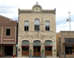 | Masonic Building | 0.7 miles | 1984 |
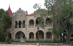 | Capt. Charles Schreiner Mansion | 0.7 miles | 1975 |
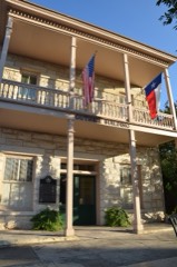 | Guthrie Building | 0.7 miles | 2011 |
| National Archives record | The nomination case file for reference 82004510 in Record Group 79. |
| Kerr County | All 5 listed properties in this county. |