 Block
BlockFrom the record
One of 7 National Register listings published here for Walker County · listed in 1982 · category: Building.
Sources: the case file at the National Archives · the National Register database, National Park Service
Listed on the National Register of Historic Places in 1982.
One of 7 National Register listings published here for Walker County · listed in 1982 · category: Building.
Sources: the case file at the National Archives · the National Register database, National Park Service
Regional context, not property-specific evidence. The federal wildfire occurrence database lists 113 fires within 5 miles of John W. Thomason House between 1992 and 2020, burning about 681 acres in total. 5 started naturally. 2 were recorded as arson. Distance is straight-line from the map coordinates, so a fire counted here may appear on a neighbouring settlement's page as well.
| Reported cause | Fires |
|---|---|
| Debris and open burning | 63 |
| Missing data/not specified/undetermined | 21 |
| Power generation/transmission/distribution | 8 |
| Equipment and vehicle use | 7 |
| Natural | 5 |
| Smoking | 3 |
| Misuse of fire by a minor | 3 |
| Arson/incendiarism | 2 |
| Railroad operations and maintenance | 1 |
The most recent of them, most recent first, with the day each was reported and the service that recorded it.
| Date | Cause | Size | Reported by | Name on the report |
|---|---|---|---|---|
| 5 September 2005 | Debris and open burning | 3.0 acres | Texas A & M Forest Service | CONROE - 95 |
| 4 September 2011 | Power generation/transmission/distribution | 1.0 acres | Livingston Area | LIVINGSTON - 838 |
| 30 September 2000 | Debris and open burning | 1.0 acres | Texas A & M Forest Service | CONROE - 432 |
| 29 September 1994 | Debris and open burning | 5.0 acres | Texas A & M Forest Service | not named |
| 29 September 1994 | Debris and open burning | 1.0 acres | Texas A & M Forest Service | not named |
| 29 September 1992 | Debris and open burning | 1.0 acres | Texas A & M Forest Service | not named |
| 22 September 2006 | Debris and open burning | 15 acres | Texas A & M Forest Service | CONROE - 203 |
| 12 September 2004 | Debris and open burning | 7.0 acres | Texas A & M Forest Service | CONROE - 22 |
Regional context, not property-specific evidence. The federal mineral resources record lists 1 working within 5 miles of John W. Thomason House: 1 past producer. None of them still produces. What was taken out: Silica. Distance is straight-line from the map coordinates, so a quarry counted here may appear on a neighbouring settlement's page as well.
| Where | Site | Commodity | Status | Recorded |
|---|---|---|---|---|
| Unknown | Silica | Past Producer |
Regional context, not property-specific evidence. The National Weather Service names Huntsville, the town this property stands in, in 83 storm reports between 1994 and 2025: 44 thunderstorm wind, 20 hail, 11 flash flood, 5 tornado. The reports record 9 injuries. Each account below is quoted exactly as the forecast office filed it, from the NOAA Storm Events Database, and each date opens the federal record of that event.
| When | Event | Place named | Harm | What the report says |
|---|---|---|---|---|
| January 1999 | Tornado (F1) | Huntsville | 7 hurt, $125,000 | Tornado touchdown in the Acres Hills subdivision just NE of Huntsville. One mobile home completely destroyed. Three people inside escaped with fairly minor injuries (cuts and abrasions, separated shoulder). A large oak tree bisected another trailer down the road pinning the resident who was later Life Flighted to Houston and had a broken leg and ankle, and a collapsed lung. Three other residents sustained minor injuries (lacerations, etc). Numerous trees and roof damage was noted throughout the remainder of the subdivision. |
| March 1995 | Thunderstorm Wind | Huntsville | 2 hurt, $20,000 | Sheriffs reported that downburst winds destroyed one mobile home and damaged three others. |
| October 1997 | Tornado (F1) | Huntsville | $150,000 | Destroyed 2 houses |
| April 2015 | Flash Flood | Huntsville | $100,000 | Heavy rain at Sam Houston State University collapsed a recreational building wall and allowed water to flow into the lower levels of the structure. Numerous parking lots were flooded. |
| April 1996 | Thunderstorm Wind | Huntsville | $75,000 | no account filed |
| January 1999 | Thunderstorm Wind | Huntsville | $74,000 | Medium sized oak tree uprooted and fell on mobile home. Uncompleted home framework collapsed. |
| May 2004 | Flash Flood | Huntsville | $60,000 | Numerous roads in and around the Huntsville area flooded and impassable. |
| May 2021 | Tornado (EF0) | Huntsville | $30,000 | A brief tornado touched down near a shopping center near Huntsville. Caused some minor damage. Circular winds observed in parking lot on video. |
| January 2012 | Tornado (EF0) | Huntsville | $30,000 | This EF-0 tornado touched down in a residential section of the Huntsville area near Roundabout Road. There was significant tree damage, and one of the trees did fall on a nearby house and caused some roof damage. Trees were blown down in different directions, giving an indication of a strong circulation in the area. |
| November 2000 | Thunderstorm Wind | Huntsville | $25,000 | Numerous trees down. |
| July 2000 | Thunderstorm Wind | Huntsville | $25,000 | Tree down on car. |
| April 2006 | Hail | Huntsville | $20,000 | Numerous reports of golfball to racquetball-size hail. |
| May 2004 | Hail | Huntsville | $20,000 | 1.75 inch hail in Huntsville. |
| April 2020 | Thunderstorm Wind | Huntsville | $16,000 | Several homes were damaged on Sleepy Hollow Circle. |
| January 2012 | Thunderstorm Wind | Huntsville | $15,000 | This severe thunderstorm produced widespread wind damage in and around the Huntsville area. Numerous trees were downed throughout the city, and a light pole was blown down on a new truck. There was also some roof damage to a bank in the middle of the city. A student at a local university was injured by a falling tree limb. |
| June 2007 | Thunderstorm Wind | Huntsville | $15,000 | Two trees down on two separate mobile homes. One mobile home received significant roof damage while the other received only minimal structural damage. Power line was also reported being downed. |
| October 2001 | Thunderstorm Wind | Huntsville | $15,000 | Newspaper reported wind damage to a mobile home. |
| November 2000 | Thunderstorm Wind | Huntsville | $15,000 | Trees down. |
| November 2000 | Thunderstorm Wind | Huntsville | $15,000 | Trees down. |
| January 1999 | Tornado (F0) | Huntsville | $15,000 | Brief tornado touchdown with trees reported down. |
| May 1999 | Thunderstorm Wind | Huntsville | $15,000 | Trees down along Ave J. |
| February 1998 | Thunderstorm Wind | Huntsville | $13,000 | 26 houses in the Elkins Lake Subdivision received minor wind damage. |
| June 2023 | Thunderstorm Wind | Huntsville | $10,000 | A tree was downed onto a home. |
| May 2004 | Thunderstorm Wind | Huntsville | $10,000 | Tree down in Pine Prairie. |
| July 1998 | Hail | Huntsville | $10,000 | Hail on HWY 190. |
| April 2020 | Thunderstorm Wind | Huntsville | $9,000 | A home was damaged on Crosstimbers Street. |
| June 2008 | Lightning | Huntsville | $8,000 | A large oak tree was struck by lightning and fell upon a couple of vehicles. |
| March 1999 | Hail | Huntsville | $7,000 | Hail report along Hwy. 30 near Grimes Co. line |
| January 2016 | Hail | Huntsville | $5,000 | Half dollar sized hail occurred just south of Huntsville. |
| July 2014 | Flash Flood | Huntsville | $5,000 | High water on roads SW of Huntsville. Public report of 7.99 inches of rain was received. |
| June 2004 | Flash Flood | Huntsville | $5,000 | Flooding of FM roads. |
| October 2001 | Thunderstorm Wind | Huntsville | $5,000 | Sheriff's office reported trees and power lines down. |
| June 1998 | Thunderstorm Wind | Huntsville | $5,000 | Trees blown down and 3/4" hail. |
| January 1998 | Hail | Huntsville | $5,000 | no account filed |
| April 1996 | Hail | Huntsville | $5,000 | no account filed |
| April 1996 | Hail | Huntsville | $5,000 | no account filed |
| September 1996 | Thunderstorm Wind | Huntsville | $5,000 | no account filed |
| September 1996 | Hail | Huntsville | $5,000 | no account filed |
| July 1994 | Thunderstorm Wind | Huntsville | $5,000 | no account filed |
| May 1994 | Thunderstorm Wind | Huntsville | $5,000 | no account filed |
| May 2008 | Thunderstorm Wind | Huntsville | $4,000 | Thunderstorm winds caused some tree damage to a residential home. |
| September 2019 | Thunderstorm Wind | Huntsville | $3,000 | Power lines were downed near the intersection of Old Colony Road and Wanza Road. |
| August 2006 | Thunderstorm Wind | Huntsville | $3,000 | Trees down near Highway 75. |
| October 2006 | Flash Flood | Huntsville | $3,000 | FM 2989 between Interstate 45 and FM 247 was closed due to flooding. |
| February 2005 | Hail | Huntsville | $3,000 | Hail was on the west side of town. |
| June 2002 | Thunderstorm Wind | Huntsville | $3,000 | Trees blown down. |
| August 1998 | Thunderstorm Wind | Huntsville | $3,000 | Trees blown down in northern Huntsville. |
| April 1998 | Hail | Huntsville | $3,000 | no account filed |
| February 2011 | Thunderstorm Wind | Huntsville | $2,000 | Large tree was downed across a road in the city of Huntsville. |
| June 2008 | Thunderstorm Wind | Huntsville | $1,000 | Two 70 to 100 foot pine trees were downed on the south side of Huntsville. |
| October 2018 | Thunderstorm Wind | Huntsville | $500 | Thunderstorm winds blew a tree down onto a fence. |
| March 2014 | Hail | Huntsville | $500 | Marble sized hail was observed on the south side of Huntsville. |
| May 2025 | Thunderstorm Wind | Huntsville | - | Broadcast media reported trees and powerlines down. |
| October 2025 | Thunderstorm Wind | Huntsville | - | Law enforcement reported downed trees and power line along Martin Luther King Dr. and 7th St. in Huntsville, TX. |
| May 2024 | Thunderstorm Wind | Huntsville | - | Power poles and three-inch tree limbs were broken. |
| May 2024 | Thunderstorm Wind | Huntsville | - | Trees were downed and limbs were broken. |
| April 2024 | Flash Flood | Huntsville | - | Multiple roadways around Huntsville were closed after becoming impassable due to floodwaters. |
| May 2024 | Flash Flood | Huntsville | - | Portions of FM 2821 to the north of Huntsville were impassable due to flash flooding. |
| January 2023 | Hail | Huntsville | - | Ping-pong ball sized hail was observed by a member of the public near Montgomery Rd and Veterans Memorial Pkwy in Huntsville. Size was estimated based on provided photos. |
| May 2023 | Thunderstorm Wind | Huntsville | - | Strong thunderstorm wind gusts blew down a large tree, which fell onto an apartment complex and caused roof damage. |
No historic map-sheet match is published for this property yet. That does not mean no map exists. This record needs a coordinate-quality review before it can be joined to a sheet boundary. Browse the county's mapped places while that work is pending.
Other National Register properties close enough to walk or drive between, ordered by distance from this one. Both positions come from the same geocoding pass that matched these properties to their map sheets.
| Photograph | Property | Distance | Listed |
|---|---|---|---|
 | Austin Hall | 0.4 miles | 2013 |
 | Sam Houston House | 0.6 miles | 1974 |
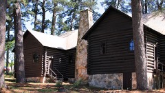 | Josey Boy Scout Lodge and Keeper's Cabin | 1.0 miles | 2018 |
| National Archives record | The nomination case file for reference 82004528 in Record Group 79. |
| Walker County | All 7 listed properties in this county. |