
BlockBefore
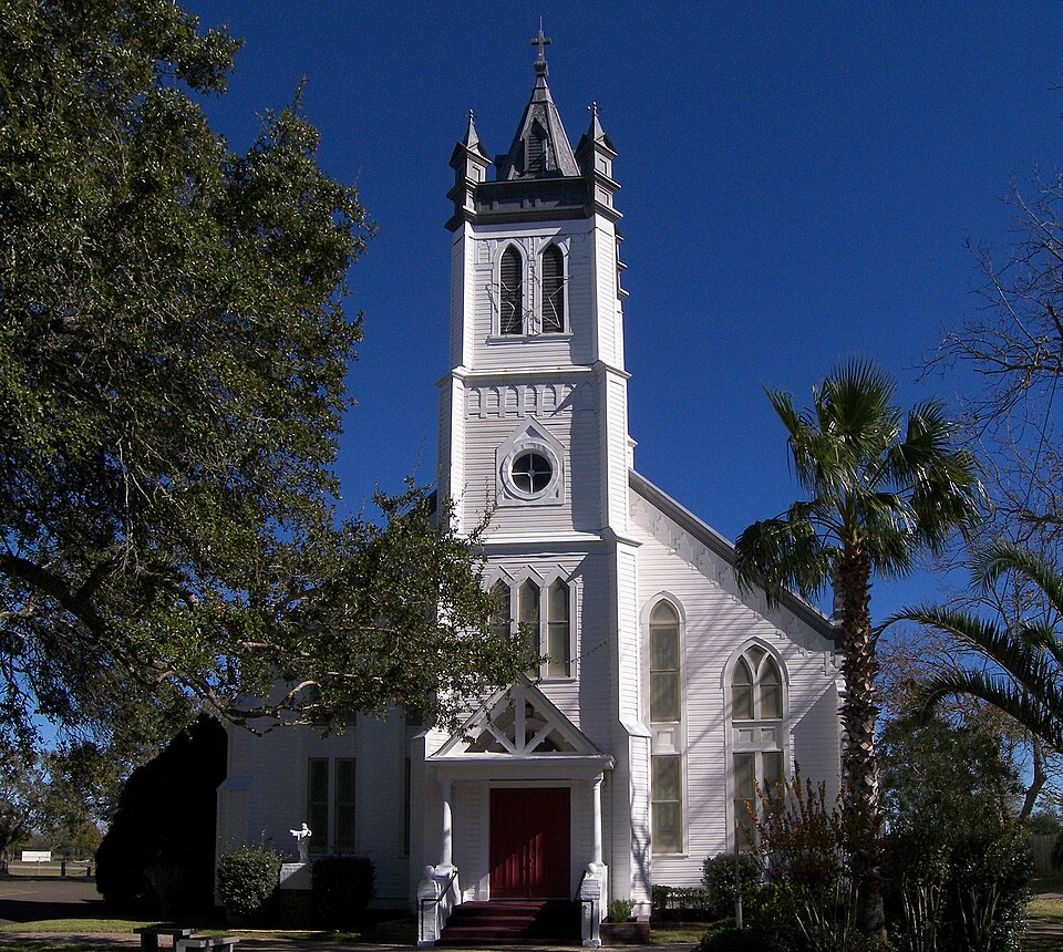
Photograph of Church of the Guardian Angel
Photograph by Larry D. Moore, CC BY 4.0. Via Wikimedia Commons.

Church of the Guardian Angel

Listed on the National Register of Historic Places in 1983.

From the record

“Church of the Guardian Angel is a historic Roman Catholic church at 5614 Demel Street in Wallis, Texas.”

Wikipedia article Church of the Guardian Angel, CC BY-SA 4.0.

One of 9 National Register listings published here for Austin County · listed in 1983 · category: Building.

Sources: the Wikipedia article · the case file at the National Archives · the National Register database, National Park Service

The listing

  • What is counted as historic. The nomination lists 1 building as contributing to the listing.
  • Address. 5614 Demel St., Wallis, 77485
  • When was it listed? June 1983
  • Category. building
  • Also known as. Churches with Decorative Interior Painting TR
  • Census division. Wallis
  • Architectural style. Gothic Revival
  • National Register reference number. 83003074 - the number the National Park Service assigned this property when it was listed, and the key its nomination file is catalogued under at the National Archives.

Fires near this property

5 since 1996

Regional context, not property-specific evidence. The federal wildfire occurrence database lists 5 fires within 5 miles of Church of the Guardian Angel between 1996 and 2016, burning about 263 acres in total. None started naturally. None was recorded as arson. Distance is straight-line from the map coordinates, so a fire counted here may appear on a neighbouring settlement's page as well.

Reported cause Fires
Debris and open burning3
Missing data/not specified/undetermined2

The most recent of them, most recent first, with the day each was reported and the service that recorded it.

DateCause SizeReported by Name on the report
17 February 2011Missing data/not specified/undetermined150 acresTexas A & M Forest ServiceGRASS FIRE
17 February 1996Missing data/not specified/undetermined5.0 acresTexas A & M Forest Servicenot named
5 November 2016Debris and open burning5.0 acresTexas A & M Forest ServiceMA GRASS FIRE WITH WALLIS FD
17 November 2016Debris and open burning3.0 acresTexas A & M Forest ServiceMA GRASS FIRE -W- WALLIS VFD
13 January 2009Debris and open burning100 acresTexas A & M Forest Service09-0000014

Every fire recorded in Austin County

Mines and quarries near this property

1 within 5 miles

Regional context, not property-specific evidence. The federal mineral resources record lists 1 working within 5 miles of Church of the Guardian Angel: 1 producer. All of them still produce. What was taken out: Sand and Gravel, Construction. Distance is straight-line from the map coordinates, so a quarry counted here may appear on a neighbouring settlement's page as well.

Where SiteCommodity StatusRecorded
Unnamed PitSand and Gravel, ConstructionProducerGravel

Every working recorded in Austin County

Storms near this property

15 since 1993

Regional context, not property-specific evidence. The National Weather Service names Wallis, the town this property stands in, in 15 storm reports between 1993 and 2023: 8 thunderstorm wind, 4 hail, 2 flash flood, 1 funnel cloud. No death or injury is recorded in these reports. Each account below is quoted exactly as the forecast office filed it, from the NOAA Storm Events Database, and each date opens the federal record of that event.

WhenEvent Place namedHarm What the report says
August 2017Flash FloodWallis$100,000Numerous roads closed due to flooding including but not limited to FM109, FM 331, FM 2429, FM 1093 and SH 36. Moderate, yet record, flooding along the Brazos at San|Felipe caused several homes to flood along FM 1458. Inundation ranged from 4 to 7 feet of water. Minimal impacts were observed at Mill creek near Bellville. No impacts were observed from the minor flooding at the Brazos river near Hempstead.
December 2002Thunderstorm WindWallis$45,000Trees downed, barns and buildings damaged along Highway 36 between Wallis and Orchard.
March 2007Thunderstorm WindWallis$25,000Numerous cedar trees downed around home with a mobile trailer flipped over. Roof blown off a horse barn with minor damage to surrounding small structures off of Highway 60.
May 2010Thunderstorm WindWallis$10,000Severe thunderstorm wind gusts downed trees and power lines from Brazoria southwestward to around 1 mile west of the San Bernard River.
February 1998Thunderstorm WindWallis$10,000Roof damage and trees blown down.
August 1996HailWallis$10,000no account filed
May 1993Thunderstorm WindWallis$5,000The Texas Department of Safety reported metal outbuildings were blown over of FM 949 between Cat Spring and San Felipe.
May 1993HailWallis$5,000The Austin County Sheriff's Department relayed a public report of nickel-size hail in Wallis.
November 1995HailWallis$5,000no account filed
September 2011Thunderstorm WindWallis$3,000Severe thunderstorm winds downed numerous power lines south of Wallis which left most of the community without power.
February 1999HailWallis$3,000no account filed
February 2012Thunderstorm WindWallis$2,000Tree was downed on Birch Street due to thunderstorm winds.
September 2023Flash FloodWallis-Heavy rain resulted in street flooding in the Meadow Bend subdivision near FM518 in League City.
August 2021Funnel CloudWallis-A funnel cloud was sighted in the Offatts Bayou area near Galveston Island.
May 2000Thunderstorm WindWallis-Crops destroyed from Wallis to the Ft. Bend county line.

Every storm recorded in Austin County

Map coverage status

No historic map-sheet match is published for this property yet. That does not mean no map exists. This record needs a coordinate-quality review before it can be joined to a sheet boundary. Browse the county's mapped places while that work is pending.

Sources for this property

National Archives recordThe nomination case file for reference 83003074 in Record Group 79.
Wikipedia articleCommunity-written account of this property, licensed CC BY-SA.
Austin CountyAll 9 listed properties in this county.

Provenance

  • Listing record. National Park Service National Register of Historic Places, listed-properties dataset, current to 2026-05-22.
  • Map join. Address geocoded through the United States Census geocoder, then tested against the published boundary of every sheet in the USGS Historical Topographic Map Collection.
  • How this page is made. Listing fields come from federal records; map-sheet coverage is a labelled coordinate-to-boundary calculation, not a source-field claim.
  • Wildfire. Short, Karen C. 2022. Spatial wildfire occurrence data for the United States, 1992-2020 [FPA_FOD_20221014]. 6th Edition. Fort Collins, CO: Forest Service Research Data Archive. https://doi.org/10.2737/RDS-2013-0009.6 Collected with United States Government funding and usable without additional permissions or fees.
  • Mines and quarries. USGS Mineral Resources Data System (MRDS) https://mrdata.usgs.gov/mrds/ A work of the United States government, no copyright under 17 U.S.C. 105.
  • Storms. NOAA National Centers for Environmental Information, Storm Events Database https://www.ncei.noaa.gov/stormevents/ A work of the United States government, no copyright under 17 U.S.C. 105. Narratives are quoted verbatim from the National Weather Service report and are not edited or summarised.