 Block
BlockFrom the record
One of 4 National Register listings published here for Randall County · listed in 1983 · category: Building.
Sources: the case file at the National Archives · the National Register database, National Park Service
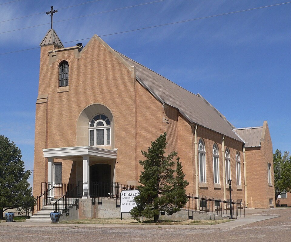
Listed on the National Register of Historic Places in 1983.
One of 4 National Register listings published here for Randall County · listed in 1983 · category: Building.
Sources: the case file at the National Archives · the National Register database, National Park Service
Regional context, not property-specific evidence. The federal wildfire occurrence database lists 62 fires within 5 miles of St. Mary's Catholic Church between 2002 and 2020, burning about 2,160 acres in total. 8 started naturally. None was recorded as arson. Distance is straight-line from the map coordinates, so a fire counted here may appear on a neighbouring settlement's page as well.
| Reported cause | Fires |
|---|---|
| Equipment and vehicle use | 16 |
| Missing data/not specified/undetermined | 15 |
| Debris and open burning | 14 |
| Natural | 8 |
| Railroad operations and maintenance | 4 |
| Smoking | 3 |
| Power generation/transmission/distribution | 2 |
The most recent of them, most recent first, with the day each was reported and the service that recorded it.
| Date | Cause | Size | Reported by | Name on the report |
|---|---|---|---|---|
| 5 September 2019 | Equipment and vehicle use | 1.0 acres | Texas A & M Forest Service | 1008 |
| 27 September 2015 | Debris and open burning | under an acre | Texas A & M Forest Service | 15-733 |
| 11 September 2016 | Railroad operations and maintenance | 1.0 acres | Texas A & M Forest Service | HWY 60 |
| 7 August 2019 | Missing data/not specified/undetermined | under an acre | Texas A & M Forest Service | 907 |
| 3 August 2019 | Missing data/not specified/undetermined | under an acre | Texas A & M Forest Service | 19716 |
| 29 August 2019 | Debris and open burning | 160 acres | Texas A & M Forest Service | 984 |
| 23 August 2016 | Equipment and vehicle use | under an acre | Texas A & M Forest Service | 16-658 |
| 16 August 2018 | Missing data/not specified/undetermined | 1.5 acres | Texas A & M Forest Service | REINART HAY BALE CO. |
Regional context, not property-specific evidence. The National Weather Service names Umbarger, the town this property stands in, in 104 storm reports between 1995 and 2025: 58 hail, 41 thunderstorm wind, 3 tornado, 2 flash flood. No death or injury is recorded in these reports. Each account below is quoted exactly as the forecast office filed it, from the NOAA Storm Events Database, and each date opens the federal record of that event.
| When | Event | Place named | Harm | What the report says |
|---|---|---|---|---|
| May 2013 | Hail | Umbarger | $10,000,000 | A supercell thunderstorm that developed along a retreating dryline in Deaf Smith and Oldham Counties tracked to the northeast across the southern Texas Panhandle. This supercell produced baseball size hail as it moved across the southern portion of Bushland (Randall County). The hail caused damage to structures and damaged power transformers which put off power flashes that the Bushland Emergency Manager reported. The supercell continued traveling in a northeastern direction which took it away from Bushland. |
| June 2025 | Thunderstorm Wind | Umbarger | $260,000 | Widespread wind damage occurred as a supercell moved from just west of Canyon and through Canyon. This damage consisted of snapped large and healthy tree branches , at least one uprooted tree, major roof damage, structural damage to an old outbuilding, blown over farm equipment, campers and high profile vehicles, and at least ten snapped power poles. There was also a measured wind gust of 84 mph at the mesonet site located one mile west of Canyon. |
| July 1996 | Thunderstorm Wind | Umbarger | $100,000 | no account filed |
| June 1995 | Hail | Umbarger | $100,000 | no account filed |
| May 1995 | Hail | Umbarger | $50,000 | no account filed |
| April 2010 | Thunderstorm Wind | Umbarger | $35,000 | North facing windows blown out and siding damaged at several residences just northeast of Umbarger. |
| April 2010 | Thunderstorm Wind | Umbarger | $25,000 | National Weather Service damage survey indicated that wind blown hail damaged residences and several other nearby residences. North facing windows blown out and north facing siding were damaged along with hundreds of acres of crops destroyed. The wind damage was likely due to the rear flank downdraft. |
| June 2025 | Hail | Umbarger | $20,000 | A supercell thunderstorm brought a swath of large hail to portions of Randall County. Baseball size hail was measured in Umbarger. Golfball size hail fell around four miles east northeast of Umbarger, where a windshield was broken of a Canyon Fire Department vehicle that was located along Highway 60 between Umbarger and Canyon. Quarter to golfball size hail fell in Canyon. Ping pong ball to golfball size hail with a few two inch size hailstones fell on the west side of Canyon. |
| June 2012 | Thunderstorm Wind | Umbarger | $20,000 | The Office of Emergency Management for Amarillo/Potter/Randall reported that the thunderstorm wind gusts knocked off a tractor trailer off its jacks and was blown over. There were also power lines that were blown down. There were no reports of injuries or fatalities. |
| May 2008 | Thunderstorm Wind | Umbarger | $15,000 | A trained spotter reported that a semi trailer and a storage building had blown over. The trained spotter also reported that barn doors had blown in and that a barn roof was blown off. |
| May 2008 | Thunderstorm Wind | Umbarger | $13,000 | The Canyon Fire Department relayed the report of three power poles pulled out of the ground by the high winds and a roof was blown off of a barn in Umbarger. |
| June 2009 | Thunderstorm Wind | Umbarger | $6,000 | Strong thunderstorm wind gusts caused numerous sheets of tin to be removed from small structures along U.S. Highway 60. There were also some downed tree branches that were observed. |
| May 2008 | Thunderstorm Wind | Umbarger | $6,000 | The Canyon Fire Department reported power lines down from the high winds. |
| June 2025 | Thunderstorm Wind | Umbarger | - | The mesonet site located at three miles north-northeast of Umbarger measured a wind gust of 72mph. |
| June 2021 | Thunderstorm Wind | Umbarger | - | The 60 mph wind gust occurred during light rain. |
| May 2020 | Hail | Umbarger | - | Half dollar size hail was observed 3 miles west-southwest of Umbarger. |
| March 2019 | Hail | Umbarger | - | Report received from spotter network. |
| March 2019 | Tornado (EFU) | Umbarger | - | No damage observed. Track and times estimated based on three separate videos and pictures. |
| August 2018 | Thunderstorm Wind | Umbarger | - | One power pole blown down, resulting in a nearby fire. Time estimated based on radar data. |
| March 2017 | Thunderstorm Wind | Umbarger | - | Wind gust of 58 MPH at Schoolnet site at the Brandt Farms. |
| August 2015 | Thunderstorm Wind | Umbarger | - | A 64 mph wind gust was measured at the West Texas Mesonet located 3 miles north-northeast of Umbarger. |
| October 2014 | Thunderstorm Wind | Umbarger | - | Scattered thunderstorms developed across Randall County during the evening hours of the 12th. As a storm approached the town of Umbarger (Randall County), the West Texas Mesonet site three miles north-northeast of Umbarger recorded a 62 mph downburst. After producing this downburst the storm continued to move eastward across the county. |
| June 2014 | Flash Flood | Umbarger | - | A cluster of slow moving thunderstorms moved into the southwestern Texas Panhandle during the late morning hours of the 24th. This cluster of storms produced very heavy rain with reports of up to 4.50 inches of rain being produced in 2 hours. This heavy rain led to the development of flash flooding on Farm to Market road 809 west of the town of Umbarger (Randall County) between Highway 60 and Pondaseta Road. Once rain ended by 8:30 AM CST, flash flooding quickly came to an end. |
| June 2014 | Hail | Umbarger | - | A cluster of storms moved out of the Eastern Plains of New Mexico during the late morning hours of the 24th. As this cluster neared the town of Umbarger (Randall County), a member of the public 2 miles north of Umbarger (Randall County) reported hail up to the size of quarters (1.00 inch). After producing this hail, the cluster of storms continued to slowly move eastward across the southern Texas Panhandle. |
| June 2014 | Hail | Umbarger | - | A cluster of thunderstorms developed along a stalled frontal boundary during the early morning hours of the 6th. These thunderstorms quickly intensified while moving to the east. As the storms neared the city of Amarillo (Randall County), a member of the public 4 miles south of Bushland (Randall County) reported quarter size hail (1.00 inch). After producing this hail the cluster of thunderstorms continued to move across the southern Texas Panhandle. |
| June 2013 | Thunderstorm Wind | Umbarger | - | A line of thunderstorms developed over the southern Texas Panhandle during the late night hours of the 16th. This line quickly showed indications that damaging winds would be the primary hazard. As the line moved close to the town of Umbarger (Randall County), the KVII Schoolnet site at Brandt Farms (Randall County) measured a 60 mph downdraft gust. The line quickly moved to the southeast after producing this gust. |
| June 2013 | Hail | Umbarger | - | An embedded thunderstorm broke off from a line of storms moving across Northwest Texas. This storm moved to the northeast and moved across the southern Texas Panhandle during the evening hours of the 20th. As the thunderstorm moved across Randall County, a member of the public reported quarter size hail (1.00 inch) eight miles south-southeast of Bushland (Randall County). The thunderstorm continued to move to the northeast across the county after producing this hail, before diminishing over the central portion of Amarillo (Randall County). |
| June 2013 | Hail | Umbarger | - | An embedded thunderstorm broke off from a line of storms moving across Northwest Texas. This storm moved to the northeast and moved across the southern Texas Panhandle during the evening hours of the 20th. As the thunderstorm moved across Randall County, a member of the public reported quarter size hail (1.00 inch) six miles south of Bushland (Randall County). The thunderstorm continued to move to the northeast across the county after producing this hail, before diminishing over the central portion of Amarillo (Randall County). |
| June 2013 | Hail | Umbarger | - | An embedded thunderstorm broke off from a line of storms moving across Northwest Texas. This storm moved to the northeast and moved across the southern Texas Panhandle during the evening hours of the 20th. As the thunderstorm moved across Randall County, a member of the public reported ping pong ball size hail (1.50 inches) seven miles south of Bushland (Randall County). The thunderstorm continued to move to the northeast across the county after producing this hail, before diminishing over the central portion of Amarillo (Randall County). |
| June 2013 | Hail | Umbarger | - | An embedded thunderstorm broke off from a line of storms moving across Northwest Texas. This storm moved to the northeast and moved across the southern Texas Panhandle during the evening hours of the 20th. As the thunderstorm moved across Randall County, a member of the public reported quarter size hail (1.00 inch) six miles south of Bushland (Randall County). The thunderstorm continued to move to the northeast across the county after producing this hail, before diminishing over the central portion of Amarillo (Randall County). |
| June 2013 | Hail | Umbarger | - | An embedded thunderstorm broke off from a line of storms moving across Northwest Texas. This storm moved to the northeast and moved across the southern Texas Panhandle during the evening hours of the 20th. As the thunderstorm moved across Randall County, a member of the public reported quarter size hail (1.00 inch) eight miles north of Canyon (Randall County). The thunderstorm continued to move to the northeast across the county after producing this hail, before diminishing over the central portion of Amarillo (Randall County). |
| April 2012 | Hail | Umbarger | - | The trained spotter reported that the hail was covering U.S. Highway 60 and that the roads were slick in the town of Umbarger, Texas. |
| April 2012 | Hail | Umbarger | - | The trained spotter reported that there was a lot of hail covering the ground. |
| April 2010 | Tornado (EF0) | Umbarger | - | A tornado survey was conducted on this tornado. The tornado touched down at 1847 CST approximately three miles northeast of Umbarger. The tornado was on the ground for approximately one mile or less with a path width of fifty yards. The tornado dissipated at approximately 1849 CST approximately four miles northeast of Umbarger. The tornado remained over open country and no damage or injuries were reported directly from the tornado. However...several homes received damage from wind blown hail associated with the rear flank downdraft. Several north facing windows were blown out and hundreds of acres of crops were destroyed. |
| June 2009 | Thunderstorm Wind | Umbarger | - | The Randall County Emergency Manager estimated thunderstorm wind gusts of fifty-six knots about seven miles west of Canyon. |
| June 2009 | Thunderstorm Wind | Umbarger | - | The broadcast media estimated thunderstorm wind gusts of fifty-two knots in Umbarger. |
| April 2007 | Hail | Umbarger | - | Reported at the intersection of U.S. Highway 60 and Farm to Market Road 168. |
| June 2007 | Hail | Umbarger | - | Reported on County Road 34 near Westline Road. |
| June 2003 | Flash Flood | Umbarger | - | Major street flooding reported in the town of Umbarger. |
| June 2025 | Thunderstorm Wind | Umbarger | - | no account filed |
| May 2024 | Thunderstorm Wind | Umbarger | - | no account filed |
| April 2023 | Hail | Umbarger | - | no account filed |
| August 2023 | Thunderstorm Wind | Umbarger | - | no account filed |
| May 2023 | Thunderstorm Wind | Umbarger | - | no account filed |
| July 2023 | Thunderstorm Wind | Umbarger | - | no account filed |
| June 2023 | Hail | Umbarger | - | no account filed |
| June 2023 | Hail | Umbarger | - | no account filed |
| May 2022 | Hail | Umbarger | - | no account filed |
| May 2022 | Thunderstorm Wind | Umbarger | - | no account filed |
| May 2022 | Hail | Umbarger | - | no account filed |
| May 2022 | Hail | Umbarger | - | no account filed |
| May 2022 | Thunderstorm Wind | Umbarger | - | no account filed |
| June 2022 | Thunderstorm Wind | Umbarger | - | no account filed |
| May 2021 | Thunderstorm Wind | Umbarger | - | no account filed |
| May 2021 | Hail | Umbarger | - | no account filed |
| May 2021 | Hail | Umbarger | - | no account filed |
| May 2021 | Hail | Umbarger | - | no account filed |
| May 2021 | Hail | Umbarger | - | no account filed |
| May 2021 | Hail | Umbarger | - | no account filed |
| May 2021 | Hail | Umbarger | - | no account filed |
No historic map-sheet match is published for this property yet. That does not mean no map exists. This record needs a coordinate-quality review before it can be joined to a sheet boundary. Browse the county's mapped places while that work is pending.
| National Archives record | The nomination case file for reference 83003159 in Record Group 79. |
| Randall County | All 4 listed properties in this county. |