 Block
BlockFrom the record
One of 4 National Register listings published here for Liberty County · listed in 1984 · category: Building.
Sources: the case file at the National Archives · the National Register database, National Park Service
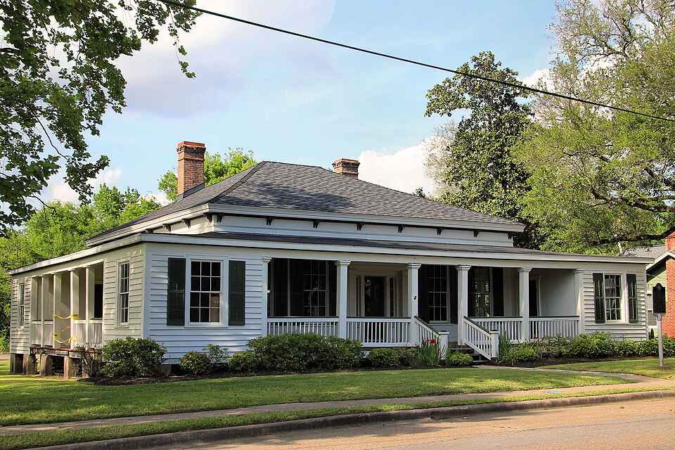
Listed on the National Register of Historic Places in 1984.
One of 4 National Register listings published here for Liberty County · listed in 1984 · category: Building.
Sources: the case file at the National Archives · the National Register database, National Park Service
Regional context, not property-specific evidence. The federal wildfire occurrence database lists 10 fires within 5 miles of Cleveland-Partlow House between 1996 and 2018, burning about 213 acres in total. None started naturally. 1 was recorded as arson. Distance is straight-line from the map coordinates, so a fire counted here may appear on a neighbouring settlement's page as well.
| Reported cause | Fires |
|---|---|
| Debris and open burning | 6 |
| Missing data/not specified/undetermined | 2 |
| Arson/incendiarism | 1 |
| Misuse of fire by a minor | 1 |
The most recent of them, most recent first, with the day each was reported and the service that recorded it.
| Date | Cause | Size | Reported by | Name on the report |
|---|---|---|---|---|
| 21 September 2005 | Debris and open burning | 1.0 acres | Texas A & M Forest Service | not named |
| 11 September 2005 | Debris and open burning | 1.0 acres | Texas A & M Forest Service | not named |
| 3 March 2000 | Debris and open burning | 16 acres | Texas A & M Forest Service | CONROE - 250 |
| 13 March 2000 | Arson/incendiarism | 120 acres | Texas A & M Forest Service | CONROE - 293 |
| 1 March 2013 | Debris and open burning | 3.0 acres | Texas A & M Forest Service | 8006 |
| 5 December 2018 | Missing data/not specified/undetermined | 50 acres | Texas A & M Forest Service | LIBERTY 14:19 |
| 11 December 2005 | Debris and open burning | 1.0 acres | Texas A & M Forest Service | not named |
| 19 October 2005 | Debris and open burning | 1.0 acres | Texas A & M Forest Service | not named |
Regional context, not property-specific evidence. The federal mineral resources record lists 1 working within 5 miles of Cleveland-Partlow House: 1 occurrence. None of them still produces. What was taken out: Sulfur, Halite, Limestone, Ultra Pure, Gypsum-Anhydrite. Distance is straight-line from the map coordinates, so a quarry counted here may appear on a neighbouring settlement's page as well.
| Where | Site | Commodity | Status | Recorded |
|---|---|---|---|---|
| South Liberty Occurrence | Sulfur, Halite, Limestone, Ultra Pure, Gypsum-Anhydrite | Occurrence | 1905 |
Regional context, not property-specific evidence. The National Weather Service names Liberty, the town this property stands in, in 31 storm reports between 1995 and 2023: 12 thunderstorm wind, 8 hail, 6 tornado, 5 flash flood. The reports record 24 injuries. Each account below is quoted exactly as the forecast office filed it, from the NOAA Storm Events Database, and each date opens the federal record of that event.
| When | Event | Place named | Harm | What the report says |
|---|---|---|---|---|
| May 1995 | Tornado (F1) | Liberty | 12 hurt, $750,000 | Super cell moved across Lake Houston and intensified to form a mesocyclone as it moved into Liberty County. This super cell produced four tornadoes as moved from west to east across the county. The third of the four tornadoes touched down in downtown Liberty and was the most significant. Twelve people were injured with two requiring to be hospitalized. |
| May 1995 | Tornado (F1) | Liberty | 12 hurt, $750,000 | Super cell moved across Lake Houston and intensified to form a mesocyclone as it moved into Liberty County. This super cell produced four tornadoes as it moved from west to east across the county. The third of the four tornadoes touched down in downtown Liberty and was the most significant. Twelve people were injured with two requiring to be hospitalized. |
| December 2002 | Thunderstorm Wind | Liberty | $70,000 | Damage to homes, carports and patio covers, high school press box and dugouts; trees and power lines down. |
| April 2006 | Tornado (F1) | Liberty | $60,000 | Tornado caused extensive damage along CR 143 off of FM 563. Major roof damage to area homes with numerous trees and power lines down. |
| November 2004 | Thunderstorm Wind | Liberty | $40,000 | Damage to retail store, several cars in parking lot also damaged. |
| May 1999 | Thunderstorm Wind | Liberty | $40,000 | Home damaged and numerous trees and power lines down. |
| September 2002 | Flash Flood | Liberty | $35,000 | Flooding in Liberty and Dayton; portions of Hwy 90 closed in Liberty. |
| December 2002 | Tornado (F0) | Liberty | $30,000 | Building damaged. |
| May 2000 | Thunderstorm Wind | Liberty | $15,000 | Trees down. |
| November 2000 | Thunderstorm Wind | Liberty | $15,000 | Power lines down in area. |
| May 1999 | Thunderstorm Wind | Liberty | $15,000 | Numerous reports of trees down across northern portion of county. |
| May 2005 | Hail | Liberty | $12,000 | Golf ball size hail on FM 1011. |
| April 2000 | Hail | Liberty | $10,000 | no account filed |
| April 2012 | Thunderstorm Wind | Liberty | $5,000 | Numerous trees downed across the western portion of the county. |
| February 2011 | Thunderstorm Wind | Liberty | $5,000 | Numerous trees were reported downed across the county. |
| October 1997 | Tornado (F0) | Liberty | $5,000 | Trees blown down. |
| January 1997 | Thunderstorm Wind | Liberty | $5,000 | no account filed |
| August 1996 | Hail | Liberty | $5,000 | no account filed |
| April 2019 | Thunderstorm Wind | Liberty | $4,000 | There was a large tree blown down onto a car. |
| March 2009 | Hail | Liberty | $4,000 | Golf ball-sized hail was reported in Liberty. |
| February 1998 | Thunderstorm Wind | Liberty | $3,000 | Trees blown down along HWY 90. |
| April 2012 | Hail | Liberty | $2,000 | Dime and quarter sized hail fell at the Liberty County Sheriff's Office for approximately 7 minutes. |
| July 1997 | Thunderstorm Wind | Liberty | $2,000 | KSHM radio had trees blown down. |
| April 2023 | Hail | Liberty | - | There was quarter sized hail in Liberty. |
| September 2019 | Flash Flood | Liberty | - | Numerous vehicles stranded by high water in and near Liberty. |
| August 2017 | Flash Flood | Liberty | - | Portions of FM 563 were covered with high water and had become impassable. |
| April 2015 | Flash Flood | Liberty | - | Flooding was reported between Liberty and Anahuac on FM 563, and also between Liberty and Daisetta along FM 160 East. |
| June 2013 | Hail | Liberty | - | A severe thunderstorm produced golf ball size hail. |
| April 2009 | Hail | Liberty | - | Penny sized hail was observed in Liberty. |
| June 2006 | Flash Flood | Liberty | - | Highway 90 flooded in the town of Liberty. |
| November 2004 | Tornado (F0) | Liberty | - | This tornado occurred over open land and caused no damage. |
No historic map-sheet match is published for this property yet. That does not mean no map exists. This record needs a coordinate-quality review before it can be joined to a sheet boundary. Browse the county's mapped places while that work is pending.
Other National Register properties close enough to walk or drive between, ordered by distance from this one. Both positions come from the same geocoding pass that matched these properties to their map sheets.
| Photograph | Property | Distance | Listed |
|---|---|---|---|
 | Liberty County Courthouse | 0.8 miles | 2002 |
| Thomas Jefferson Chambers House | 0.8 miles | 2011 | |
 | State Highway 3 Bridge at the Trinity River | 2.1 miles | 1996 |
| National Archives record | The nomination case file for reference 84001907 in Record Group 79. |
| Liberty County | All 4 listed properties in this county. |