 Block
BlockFrom the record
One of 9 National Register listings published here for Grayson County · listed in 1986 · category: Building.
Sources: the case file at the National Archives · the National Register database, National Park Service
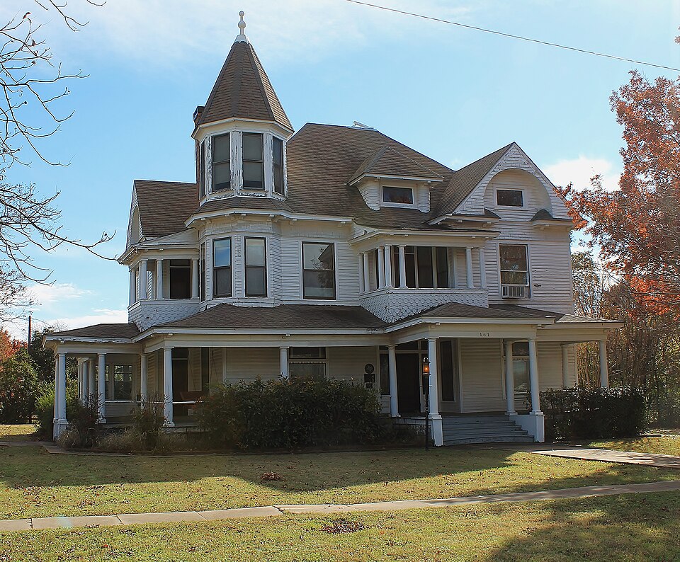
Listed on the National Register of Historic Places in 1986.
One of 9 National Register listings published here for Grayson County · listed in 1986 · category: Building.
Sources: the case file at the National Archives · the National Register database, National Park Service
Regional context, not property-specific evidence. The federal wildfire occurrence database lists 128 fires within 5 miles of Umphress-Taylor House between 2005 and 2017, burning about 1,311 acres in total. 1 started naturally. 7 were recorded as arson. Distance is straight-line from the map coordinates, so a fire counted here may appear on a neighbouring settlement's page as well.
| Reported cause | Fires |
|---|---|
| Missing data/not specified/undetermined | 62 |
| Debris and open burning | 39 |
| Equipment and vehicle use | 10 |
| Arson/incendiarism | 7 |
| Smoking | 3 |
| Misuse of fire by a minor | 2 |
| Recreation and ceremony | 2 |
| Power generation/transmission/distribution | 2 |
| Natural | 1 |
The most recent of them, most recent first, with the day each was reported and the service that recorded it.
| Date | Cause | Size | Reported by | Name on the report |
|---|---|---|---|---|
| 4 September 2005 | Debris and open burning | 10 acres | Texas A & M Forest Service | not named |
| 30 September 2005 | Missing data/not specified/undetermined | 1.0 acres | Texas A & M Forest Service | not named |
| 3 September 2005 | Debris and open burning | 5.0 acres | Texas A & M Forest Service | not named |
| 3 September 2005 | Debris and open burning | 1.0 acres | Texas A & M Forest Service | not named |
| 23 September 2011 | Debris and open burning | 7.0 acres | Texas A & M Forest Service | KNOB HILL FIRE |
| 21 September 2011 | Missing data/not specified/undetermined | 2.0 acres | Texas A & M Forest Service | CR 478 FIRE |
| 21 September 2011 | Debris and open burning | 2.0 acres | Texas A & M Forest Service | SISTER GROVE FIRE |
| 21 September 2011 | Power generation/transmission/distribution | under an acre | Texas A & M Forest Service | GF |
Regional context, not property-specific evidence. The National Weather Service names Van Alstyne, the town this property stands in, in 42 storm reports between 1995 and 2025: 21 hail, 15 thunderstorm wind, 5 flash flood, 1 lightning. No death or injury is recorded in these reports. Each account below is quoted exactly as the forecast office filed it, from the NOAA Storm Events Database, and each date opens the federal record of that event.
| When | Event | Place named | Harm | What the report says |
|---|---|---|---|---|
| May 2009 | Thunderstorm Wind | Van Alstyne | $100,000 | Three businesses at the Wilson N. Jones Plaza located on the northeast corner of HWY 75 and FM 121 in Van Alstyne partially lost their roof due to straight line winds. Extensive water damage was sustained in the buildings. In addition, several trees were down in town and some fell on houses and vehicles. |
| April 1998 | Lightning | Van Alstyne | $60,000 | A lightning strike started a house fire, destroying the house and contents. |
| September 2025 | Thunderstorm Wind | Van Alstyne | $10,000 | A public report indicated that several trees and power lines were blown down in and around Van Alstyne, with widespread power outages reported. A FEMA employee reported 12 inch or larger diameter trees were snapped just south of Van Alstyne. |
| June 2002 | Thunderstorm Wind | Van Alstyne | $10,000 | 18 wheelers on Highway 75 blown over, signs blown down, and large tree was blown onto a house. |
| February 1998 | Thunderstorm Wind | Van Alstyne | $10,000 | Trees were blown down by strong winds and windows were broken. |
| June 2009 | Thunderstorm Wind | Van Alstyne | $8,000 | Estimated winds of 65 mph blew down trees, fences, power poles, and power lines in Van Alstyne. Some trees fell on power lines. One large tree in particular snapped about half way up and partially fell onto the building of the Van Alstyne Leader. |
| June 2023 | Hail | Van Alstyne | $7,000 | no account filed |
| September 2025 | Hail | Van Alstyne | $5,000 | Golf ball sized hail was reported in Van Alstyne. |
| May 2007 | Flash Flood | Van Alstyne | $5,000 | Water over six inches was flowing over the roads in Whitewright, and at least two roads had to be closed. In Van Alstyne, county roads and yards were underwater. A trailer was also flooded. |
| July 1995 | Thunderstorm Wind | Van Alstyne | $4,000 | Power lines were blown down across the southern part of the county. |
| May 2007 | Thunderstorm Wind | Van Alstyne | $3,000 | Power lines blown down. Winds estimated at 60 MPH. |
| May 2000 | Thunderstorm Wind | Van Alstyne | $2,000 | Trees and power lines were blown down. |
| April 2025 | Hail | Van Alstyne | - | A trained spotter reported penny sized hail in Van Alstyne. |
| July 2025 | Thunderstorm Wind | Van Alstyne | - | A public report indicated multiple trees down in Van Alstyne, just north of Panther Pkwy and west of US Highway 75. |
| September 2025 | Hail | Van Alstyne | - | Reported via mPing. |
| September 2025 | Hail | Van Alstyne | - | Reported via mPing. |
| May 2024 | Flash Flood | Van Alstyne | - | Emergency management reported 8 to 10 inches of water on roadways at the intersection of US 75 and FM 121. US 75 became closed due to high water. |
| May 2024 | Hail | Van Alstyne | - | Emergency manager reported 1 inch hail in Van Alstyne. |
| March 2023 | Thunderstorm Wind | Van Alstyne | - | A wind gust of 71 mph was measured at U.S. Highway 75 and County Line Road on the far south side of Van Alstyne. |
| April 2022 | Hail | Van Alstyne | - | A photograph on social media indicated quarter sized hail in Van Alstyne, TX. |
| November 2018 | Hail | Van Alstyne | - | A trained spotter reported quarter sized hail approximately 4 miles south of the city of Van Alstyne, TX. |
| May 2015 | Flash Flood | Van Alstyne | - | A social media report stated that flooding was occurring on Highway 75 near exit 51 in Van Alstyne, TX. |
| October 2014 | Thunderstorm Wind | Van Alstyne | - | The sheriff's department reported that trees were blown down in Van Alstyne and Sherman. |
| May 2008 | Thunderstorm Wind | Van Alstyne | - | Winds were estimated in excess of 65 MPH. |
| May 2007 | Hail | Van Alstyne | - | Quarter-size hail covering the ground. |
| May 2007 | Hail | Van Alstyne | - | Lasted about 10 minutes. |
| September 2005 | Thunderstorm Wind | Van Alstyne | - | A tree was blown down. |
| March 2002 | Flash Flood | Van Alstyne | - | The bridge at Eagle Point Crossing just west of Van Alstyne on FM 121 was washed out. |
| September 2001 | Flash Flood | Van Alstyne | - | Streets in town flooded. |
| April 1999 | Thunderstorm Wind | Van Alstyne | - | A trained spotter reported 60 to 70 mph winds associated with thunderstorms. |
| July 1995 | Thunderstorm Wind | Van Alstyne | - | Several large trees were blown down by high winds. |
| May 2024 | Hail | Van Alstyne | - | no account filed |
| May 2015 | Hail | Van Alstyne | - | no account filed |
| September 2011 | Hail | Van Alstyne | - | no account filed |
| May 2008 | Hail | Van Alstyne | - | no account filed |
| May 2006 | Hail | Van Alstyne | - | no account filed |
| July 2003 | Hail | Van Alstyne | - | no account filed |
| May 2002 | Hail | Van Alstyne | - | no account filed |
| April 2000 | Hail | Van Alstyne | - | no account filed |
| April 1999 | Hail | Van Alstyne | - | no account filed |
| February 1998 | Hail | Van Alstyne | - | no account filed |
| April 1995 | Hail | Van Alstyne | - | no account filed |
No historic map-sheet match is published for this property yet. That does not mean no map exists. This record needs a coordinate-quality review before it can be joined to a sheet boundary. Browse the county's mapped places while that work is pending.
| National Archives record | The nomination case file for reference 86001956 in Record Group 79. |
| Grayson County | All 9 listed properties in this county. |