 Block
BlockFrom the record
One of 73 National Register listings published here for Tom Green County · listed in 1988 · category: Building.
Sources: the case file at the National Archives · the National Register database, National Park Service
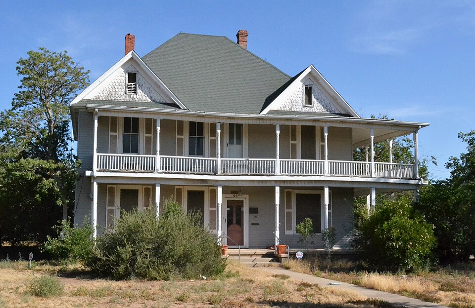
Listed on the National Register of Historic Places in 1988.
One of 73 National Register listings published here for Tom Green County · listed in 1988 · category: Building.
Sources: the case file at the National Archives · the National Register database, National Park Service
Regional context, not property-specific evidence. The federal wildfire occurrence database lists 74 fires within 5 miles of Dr. M. M. Woodward House between 2001 and 2020, burning about 585 acres in total. 1 started naturally. 3 were recorded as arson. Distance is straight-line from the map coordinates, so a fire counted here may appear on a neighbouring settlement's page as well.
| Reported cause | Fires |
|---|---|
| Missing data/not specified/undetermined | 24 |
| Debris and open burning | 22 |
| Equipment and vehicle use | 12 |
| Smoking | 5 |
| Arson/incendiarism | 3 |
| Recreation and ceremony | 3 |
| Power generation/transmission/distribution | 2 |
| Railroad operations and maintenance | 1 |
| Misuse of fire by a minor | 1 |
| Natural | 1 |
The most recent of them, most recent first, with the day each was reported and the service that recorded it.
| Date | Cause | Size | Reported by | Name on the report |
|---|---|---|---|---|
| 4 September 2008 | Debris and open burning | 1.0 acres | Texas A & M Forest Service | not named |
| 12 September 2015 | Equipment and vehicle use | under an acre | Texas A & M Forest Service | HWY 67 FIRE |
| 11 September 2010 | Equipment and vehicle use | 5.0 acres | Texas A & M Forest Service | 5500 ARDEN ROAD |
| 8 August 2013 | Missing data/not specified/undetermined | 1.0 acres | Texas A & M Forest Service | GRASS FIRE HWY 277 |
| 7 August 2013 | Missing data/not specified/undetermined | 1.0 acres | Texas A & M Forest Service | DOUGLAS/HWY 67 GRASS FIRE |
| 7 August 2011 | Debris and open burning | 10 acres | Texas A & M Forest Service | ARMSTRONG FIRE |
| 6 August 2015 | Missing data/not specified/undetermined | under an acre | Texas A & M Forest Service | GRASS FIRE HWY 67 |
| 4 August 2010 | Equipment and vehicle use | under an acre | Texas A & M Forest Service | 6700 N. US HWY 87 |
Regional context, not property-specific evidence. The federal mineral resources record lists 2 workings within 5 miles of Dr. M. M. Woodward House: 1 past producer, 1 producer. 1 still produces. What was taken out: Sand and Gravel, Construction, Stone, Crushed/Broken. Distance is straight-line from the map coordinates, so a quarry counted here may appear on a neighbouring settlement's page as well.
| Where | Site | Commodity | Status | Recorded |
|---|---|---|---|---|
| Sanco Materials Corporation | Sand and Gravel, Construction | Past Producer | ||
| Wilson Paving Company Operations | Stone, Crushed/Broken | Producer |
Regional context, not property-specific evidence. The National Weather Service names San Angelo, the town this property stands in, in 361 storm reports between 1993 and 2026: 209 hail, 79 thunderstorm wind, 59 flash flood, 9 tornado. The reports record 1 death and 73 injuries. Each account below is quoted exactly as the forecast office filed it, from the NOAA Storm Events Database, and each date opens the federal record of that event.
| When | Event | Place named | Harm | What the report says |
|---|---|---|---|---|
| July 2025 | Flash Flood | San Angelo | 1 killed | Law enforcement reported flash flooding at the intersection of Coke Street and Schroeder Street which resulted in one fatality when a vehicle was swept away by the flood waters. |
| May 1995 | Thunderstorm Wind | San Angelo | 50 hurt, $60,000,000 | no account filed |
| May 1995 | Hail | San Angelo | 10 hurt, $25,000,000 | no account filed |
| May 1995 | Hail | San Angelo | 10 hurt, $20,000,000 | no account filed |
| October 1993 | Thunderstorm Wind | San Angelo | 2 hurt, $500,000 | Ham radio operators and storm spotters reported severe weather in and near San Angelo late on the 17th. In North San Angelo, two mobile homes were demolished, with other roofs, fences, power lines, and outbuildings damaged. Two people in one the the trailers sustained minor cuts and bruises. The damage was believed to be caused by a microburst. Golfball-size hail was reported by a spotter in Carlsbad at 2112 CST. Around 2210 CST, another microburst damaged an athletic supply building and the roof of a high school in north San Angelo. Later, quarter-size hail was reported in north San Angelo by a NWS employee. At 2345 CST, a NWS employee reported Ping-Pong-size hail 4 miles northeast of the San Angelo airport. |
| September 2001 | Flash Flood | San Angelo | 1 hurt | A man caught in his vehicle in high water suffered minor injuries before he could be rescued. The man hung onto a guide wire for 20 minutes before police and fire personnel could finally wade out to reach him. |
| May 1993 | Hail | San Angelo | $50,000,000 | A severe thunderstorm moved over San Angelo and pounded the city with hail larger than baseball-size. There were numerous reports of damage to vehicles, roofs, windows, and aircraft at Mathis Field. The storm damaged over 800 vehicles and nearly 1,000 roofs, mainly in the southwestern part of the city. Insurance adjusters estimated the total damage at around $10 million. Fortunately, no injuries resulted from the storm. |
| March 2002 | Hail | San Angelo | $16,000,000 | Hail up to golf ball size pounded the southern half of San Angelo shortly after noon, creating drifts several feet deep in places. Around 3500 homes suffered light to moderate damage, along with around 4000 automobiles. Many trees were stripped of their leaves. Hail stayed on the ground for at least 8 hours in some places. |
| June 2003 | Hail | San Angelo | $10,000,000 | The community of Grape Creek was pounded by hail up to the size of tennis balls combined with winds to 70 mph. This produced considerable damage to trees, roofs and cars. Hail of golf ball size or larger fell for almost 20 minutes. Severe hail of penny size or larger fell for 50 minutes. Almost every home in the community needed roof repairs. |
| May 1995 | Hail | San Angelo | $5,000,000 | no account filed |
| May 1995 | Hail | San Angelo | $5,000,000 | no account filed |
| June 2003 | Hail | San Angelo | $4,000,000 | The thunderstorm moved from Grape Creek into the city of San Angelo. The thunderstorm produced golf ball size hail and winds to 70 mph over the north and east portions of San Angelo. This caused damage to cars, roofs and businesses. |
| June 2003 | Hail | San Angelo | $800,000 | Large hail and strong winds combined to produce significant damage to homes and cars in San Angelo. This was the second severe thunderstorm to hit the city of San Angelo in three days. |
| May 2002 | Hail | San Angelo | $500,000 | Two severe thunderstorms developed over the city of San Angelo and produced hail up to golfball size for almost 40 minutes. The hail caused considerable property damage to homes and vehicles. |
| May 1993 | Hail | San Angelo | $500,000 | A severe thunderstorm moved over San Angelo and pounded the city with hail larger than baseball-size. There were numerous reports of damage to vehicles, roofs, windows, and aircraft at Mathis Field. The storm damaged over 800 vehicles and nearly 1,000 roofs, mainly in the southwestern part of the city. Insurance adjusters estimated the total damage at around $10 million. Fortunately, no injuries resulted from the storm. |
| May 2005 | Tornado (F1) | San Angelo | $300,000 | As the supercell thunderstorm started to move just to the east of San Angelo, it became better organized and was able to produce a tornado just off of loop 306 southeast of San Angelo. Two mobile homes were damaged, and two grain elevators received substantial damage. |
| June 2003 | Lightning | San Angelo | $200,000 | Intense lightening from a severe thunderstorm produced a house fire, which was a total loss. Also numerous appliances and televisions across the city were knocked out. The National Weather Service office in San Angelo also received a lightening strike that knocked out computer systems and a amateur radio transceiver. |
| November 1996 | Thunderstorm Wind | San Angelo | $200,000 | no account filed |
| June 2003 | Flash Flood | San Angelo | $150,000 | Several cars were stranded and a restaurant was flooded. |
| May 1998 | Flash Flood | San Angelo | $150,000 | Extensive flooding in the Quail Valley subdivision, with water flowing into houses and up to 8 feet of water covering some roadways |
| May 2005 | Tornado (F1) | San Angelo | $100,000 | Just after the first tornado dissipated another tornado developed developed just to the south southeast of where the first tornado dissipated. Some damage was noted to homes, telephone poles and signs. |
| May 1998 | Flash Flood | San Angelo | $100,000 | Up to 1 foot of water flowing through several homes |
| June 1997 | Thunderstorm Wind | San Angelo | $100,000 | A severe wind and hail storm damaged roofs in the community of Grape Creek. |
| May 2002 | Hail | San Angelo | $50,000 | Several reports of golfball size hail received from the southern half of San Angelo. Damage was primarily to roofs. |
| May 2002 | Hail | San Angelo | $50,000 | Several reports of golfball size hail were received on the west side of San Angelo. |
| October 1993 | Thunderstorm Wind | San Angelo | $50,000 | Ham radio operators and storm spotters reported severe weather in and near San Angelo late on the 17th. In North San Angelo, two mobile homes were demolished, with other roofs, fences, power lines, and outbuildings damaged. Two people in one the the trailers sustained minor cuts and bruises. The damage was believed to be caused by a microburst. Golfball-size hail was reported by a spotter in Carlsbad at 2112 CST. Around 2210 CST, another microburst damaged an athletic supply building and the roof of a high school in north San Angelo. Later, quarter-size hail was reported in north San Angelo by a NWS employee. At 2345 CST, a NWS employee reported Ping-Pong-size hail 4 miles northeast of the San Angelo airport. |
| May 1995 | Hail | San Angelo | $50,000 | no account filed |
| May 1995 | Hail | San Angelo | $50,000 | no account filed |
| May 1995 | Hail | San Angelo | $40,000 | no account filed |
| May 2005 | Hail | San Angelo | $30,000 | Hail greater than golfball size and as large as Grapefruit fell on a ranch house for over an hour. Two different severe thunderstorm cores moved over the same location and caused the continuous hail. The ranch house received significant damage. |
| May 2005 | Hail | San Angelo | $30,000 | Large hail up to baseball size cut a swath from the northeast sections of San Angelo to the east side of San Angelo. This hail was from the main supercell that barely missed the downtown area of San Angelo. |
| June 1997 | Hail | San Angelo | $25,000 | One inch hail fell in the community of Grape Creek. |
| June 1997 | Flash Flood | San Angelo | $25,000 | Heavy rains fell over an area from San Angelo to Grape Creek. Three inches of rain was measured at Grape Creek while 2.75 inches of rain fell in downtown San Angelo. Chadbourne and Pulliam streets were under three feet of water and serious flooding also occurred on Concho Street. |
| May 1995 | Hail | San Angelo | $20,000 | no account filed |
| April 2006 | Hail | San Angelo | $15,000 | Damage to roofs and cars |
| April 2006 | Thunderstorm Wind | San Angelo | $15,000 | One mobile home destroyed. |
| September 2001 | Thunderstorm Wind | San Angelo | $15,000 | Severe winds destroyed a storage building, sending debris crashing into one nearby home and 2 vehicles. |
| May 2002 | Flash Flood | San Angelo | $13,000 | An isolated thunderstorm moved across northern Tom Green county around 8 am. This thunderstorm produced over 2 inched of rain in a short period of time across northern portions of San Angelo. There were several water rescues performed during the flooding. |
| May 2007 | Thunderstorm Wind | San Angelo | $12,000 | An off duty National Weather Service employee estimated 60 mph wind gusts. There was damage reported nearby to storage buildings and a local hotel lost part of it's roof. |
| June 2007 | Flash Flood | San Angelo | $10,000 | Heavy rains produced urban flooding in San Angelo with many of the low water crossings flooded on the west side of town. There were some swift water rescues performed during this heavy rain event. |
| May 2005 | Hail | San Angelo | $10,000 | This is a continuation of the large hail swath from the super cell thunderstorm moving just to the east of San Angelo. These reports were from just north of the Goodfellow Airforce Base. |
| July 2005 | Thunderstorm Wind | San Angelo | $10,000 | Mobile home received severe structural damage in the Grape Creek community. |
| August 2003 | Thunderstorm Wind | San Angelo | $10,000 | Strong thunderstorm winds went southwest to northeast across the city of San Angelo. The automated weather station at the airport reported a 69 MPH gust. The winds ripped roofs off of a few buildings. |
| March 2002 | Flash Flood | San Angelo | $10,000 | Heavy rainfall of 2 to 3 inches in less than an hour brought flash flooding to parts of San Angelo. Between 10 and 15 people were stranded in at least 7 vehicles, with the occupants rescued by emergency personnel. No injuries were reported. |
| May 2002 | Flash Flood | San Angelo | $10,000 | Excessive rains from several severe thunderstorms that moved over the city of San Angelo produced flash flooding within the city. Several streets were covered with one to three feet of water. There were some water rescues as motorists were swept away trying to go through low water crossings. |
| July 2002 | Thunderstorm Wind | San Angelo | $10,000 | Several power lines were downed for about a four mile stretch. There was also some awning damage to a convenience store. |
| September 2001 | Thunderstorm Wind | San Angelo | $10,000 | High winds struck the central and northern parts of San Angelo shortly before midnight. Central High School suffered roof damage, allowing rainwater to flow inside and causing minor damage. A roof of a warehouse at Goodfellow AFB was also blown off during the storm. |
| June 1997 | Flash Flood | San Angelo | $10,000 | Flooding occurred on Main and Pulliam streets in downtown San Angelo. |
| June 1995 | Thunderstorm Wind | San Angelo | $10,000 | no account filed |
| May 2005 | Tornado (F0) | San Angelo | $8,000 | The supercell thunderstorm re-organized well to the southeast of San Angelo over ranchland in southern Tom Green County. After a probing investigation by Weather Service employees, a rancher reported another tornado track. Damage was limited to mostly vegetation. |
| March 2004 | Thunderstorm Wind | San Angelo | $4,000 | Several trees were knocked down in San Angelo when a line of thunderstorms moved through the area. There were also a few power lines that were knocked down as well. |
| June 2002 | Thunderstorm Wind | San Angelo | $4,000 | Strong thunderstorm winds produced a gust front that contained winds of 60 to 65 mph. Damage occurred to roof of a carport just north of San Angelo. |
| May 1998 | Thunderstorm Wind | San Angelo | $3,000 | A church roof was damaged, allowing water damage below |
| March 2002 | Thunderstorm Wind | San Angelo | $2,000 | Strong winds downed 4 power poles south of San Angelo. |
| March 2002 | Tornado (F1) | San Angelo | $2,000 | A tornado touched down on the extreme southeast side of San Angelo, producing minor damage as it tracked along a 3 mile long path. Several empty mobile homes were overturned and a handful of hunting blinds tossed around by the tornado. |
| April 2001 | Thunderstorm Wind | San Angelo | $2,000 | Numerous signs downed by strong thunderstorm winds. |
| May 1998 | Thunderstorm Wind | San Angelo | $2,000 | A gas station sign was blown over onto a police car |
| March 2002 | Thunderstorm Wind | San Angelo | $1,500 | Strong winds shattered windows in at least one business, causing minor damage. |
| May 1998 | Thunderstorm Wind | San Angelo | $1,500 | Several metal storage buildings had their roofs blown off |
| May 1999 | Thunderstorm Wind | San Angelo | $1,000 | An amatuer radio tower was blown down southeast of San Angelo. |
No historic map-sheet match is published for this property yet. That does not mean no map exists. This record needs a coordinate-quality review before it can be joined to a sheet boundary. Browse the county's mapped places while that work is pending.
Other National Register properties close enough to walk or drive between, ordered by distance from this one. Both positions come from the same geocoding pass that matched these properties to their map sheets.
| Photograph | Property | Distance | Listed |
|---|---|---|---|
 | House at 1621 North Chadbourne | 0.7 miles | 1988 |
 | Collyns House | 1.3 miles | 1988 |
 | Eckert House | 1.4 miles | 1988 |
 | Greater St. Paul AME Church | 1.5 miles | 1988 |
 | First Presbyterian Church | 1.6 miles | 1988 |
 | House at 221 North Magdalen | 1.6 miles | 1988 |
| National Archives record | The nomination case file for reference 88002549 in Record Group 79. |
| Tom Green County | All 73 listed properties in this county. |