 Block
BlockFrom the record
One of 1 National Register listings published here for Motley County · listed in 1991 · category: Building.
Sources: the case file at the National Archives · the National Register database, National Park Service
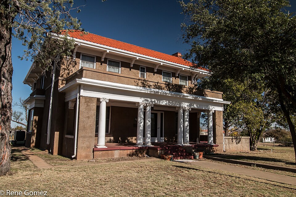
Listed on the National Register of Historic Places in 1991.
One of 1 National Register listings published here for Motley County · listed in 1991 · category: Building.
Sources: the case file at the National Archives · the National Register database, National Park Service
Regional context, not property-specific evidence. The federal wildfire occurrence database lists 37 fires within 5 miles of Traweek House between 2006 and 2020, burning about 1,537 acres in total. 4 started naturally. 3 were recorded as arson. Distance is straight-line from the map coordinates, so a fire counted here may appear on a neighbouring settlement's page as well.
| Reported cause | Fires |
|---|---|
| Missing data/not specified/undetermined | 14 |
| Equipment and vehicle use | 10 |
| Natural | 4 |
| Debris and open burning | 4 |
| Arson/incendiarism | 3 |
| Power generation/transmission/distribution | 2 |
The most recent of them, most recent first, with the day each was reported and the service that recorded it.
| Date | Cause | Size | Reported by | Name on the report |
|---|---|---|---|---|
| 8 September 2015 | Missing data/not specified/undetermined | 60 acres | Texas A & M Forest Service | MATADOR GRASS FIRE |
| 8 August 2016 | Natural | 70 acres | Texas A & M Forest Service | MATADOR RANCH |
| 17 August 2011 | Missing data/not specified/undetermined | 1.0 acres | Texas A & M Forest Service | JAMESON MACHINERY REKINDLE |
| 29 July 2018 | Natural | 45 acres | Texas A & M Forest Service | GORDON RUSSELL |
| 24 July 2016 | Equipment and vehicle use | 5.0 acres | Texas A & M Forest Service | TAYLOR |
| 23 July 2015 | Equipment and vehicle use | under an acre | Texas A & M Forest Service | NORTH MAIN |
| 14 July 2006 | Natural | 1.0 acres | Texas A & M Forest Service | not named |
| 6 June 2015 | Debris and open burning | 3.0 acres | Texas A & M Forest Service | HAWKEY |
Regional context, not property-specific evidence. The National Weather Service names Matador, the town this property stands in, in 85 storm reports between 1993 and 2025: 66 hail, 12 thunderstorm wind, 5 tornado, 1 lightning. No death or injury is recorded in these reports. Each account below is quoted exactly as the forecast office filed it, from the NOAA Storm Events Database, and each date opens the federal record of that event.
| When | Event | Place named | Harm | What the report says |
|---|---|---|---|---|
| June 2002 | Hail | Matador | $250,000 | Spotters affiliated with the Matador FD reported hail larger than golfball size. Homes and automobiles were damaged and thousands of acres of crops were destroyed. |
| June 2009 | Hail | Matador | $25,000 | Local fire department officials reported two inch diameter hail in Matador at 16:35 CST. Minor damages to vehicles and roofs occurred. |
| June 2009 | Hail | Matador | $25,000 | An off-duty National Weather Service employee reported giant two and a half inch diameter hail in Matador. Minor damages to vehicles and roofs occurred. |
| April 2003 | Hail | Matador | $25,000 | Storm spotters affiliated with the Matador Fire Department reported golfball size hail. |
| April 2015 | Thunderstorm Wind | Matador | $20,000 | Downburst winds in the rear flank downdraft of a supercell caused scattered wind damage in Matador and also overturned a semi-truck on US Highway 62 east of Matador. The driver was not injured. Wind damage in and around Matador consisted of a portion of a roof removed from a house, several large trees downed and some fallen power lines. |
| June 2014 | Hail | Matador | $15,000 | By early this evening, the same slow-moving supercell that produced very large hail in portions of Floyd County drifted into Motley County. Several reports were received of hail up to golf ball size from about four miles west of Matador extending into the city. Damage was mostly relegated to vehicle dents in Matador. |
| June 2013 | Hail | Matador | $15,000 | A local fire department official observed quarter size hail north of Matador. Additionally, damage to trees and roofs were reported on the north side of Matador. |
| July 2008 | Thunderstorm Wind | Matador | $15,000 | Severe thunderstorm winds blew down several utility poles along U.S. Highway 62/70 east of Matador. Power outages resulted with an unknown number of rural customers affected. |
| August 2010 | Thunderstorm Wind | Matador | $10,000 | The Matador Fire Department reported that thunderstorm winds downed several utility lines along Texas Highway 70 north of Matador. |
| May 1998 | Thunderstorm Wind | Matador | $10,000 | no account filed |
| June 1997 | Thunderstorm Wind | Matador | $10,000 | no account filed |
| April 2003 | Thunderstorm Wind | Matador | $5,000 | Strong thunderstorm wind blew down trees and power lines in town. A storm spotter affiliated with the VFD estimated winds to be around 60 mph. |
| August 2014 | Thunderstorm Wind | Matador | $1,000 | The COOP observer in Matador reported a damaged Fischer Porter precipitation gauge. The damage was caused from a blow by a pig shelter that became airborne in severe winds. |
| May 2000 | Lightning | Matador | $1,000 | Lightning struck a home and damaged some electronic equipment. |
| May 1993 | Hail | Matador | $50 | Off-duty National Weather Service personnel reported nickel-size hail in Matador. No significant damage resulted. |
| May 2025 | Hail | Matador | - | Numerous storm chasers reported a swath of extremely large hail west of Matador along US Highway 62/70. Hail ranged in size from quarter size to three inches in diameter. No damage was included with the reports. |
| May 2025 | Hail | Matador | - | An NWS cooperative weather observer reported ping pong ball size hail on the northeast side of Matador. |
| April 2025 | Hail | Matador | - | A report from the public was received of hail measuring five inches in diameter. This hail was from the same swath in Floyd County which produced hail up to 5.20 inches in diameter. No damage was reported. |
| June 2025 | Thunderstorm Wind | Matador | - | A Texas Tech University West Texas mesonet site near Matador measured a wind gust of 60 mph. |
| June 2023 | Tornado (EFU) | Matador | - | The fourth of several tornadoes occurred approximately four miles west of Matador. Local broadcast media live streamed a tornado that crossed US Highway 62. No known damage occurred. |
| June 2023 | Hail | Matador | - | An emergency management official and NWS cooperative weather observer reported hail ranging in size from baseballs to 4.50 inches in diameter. |
| May 2022 | Hail | Matador | - | An NWS cooperative weather observer reported golf ball size hail in Matador. |
| June 2022 | Hail | Matador | - | An NWS cooperative weather observer near Matador reported baseball ball size hail. There was an unknown amount of damage to vehicles in the area. |
| May 2021 | Hail | Matador | - | The Motley County sheriff's office reported ping pong ball size hail in Matador. |
| May 2019 | Hail | Matador | - | An emergency manager reported quarter size hail in Matador. |
| July 2019 | Thunderstorm Wind | Matador | - | An emergency manager estimated wind gusts to 60 mph in the town of Matador. The strong winds were also accompanied by nickel size hail. |
| April 2018 | Hail | Matador | - | No damage was reported. |
| December 2018 | Hail | Matador | - | Hail up to quarter size was covering Highway 62 near Matador. Damage reports were not available. |
| May 2017 | Tornado (EFU) | Matador | - | A storm chaser documented a brief tornado east of Matator. No damage occurred, therefore an EF-Unknown rating was assigned. |
| May 2016 | Hail | Matador | - | The emergency manager in Motley County reported two inch size hail east of Matador. No damage was reported. |
| May 2015 | Hail | Matador | - | Severe hail from quarter to 1.5 inches in diameter was reported from Matador to Northfield. Damage was unknown. |
| April 2015 | Hail | Matador | - | A citizen in Matador forwarded a photo to the NWS Lubbock staff of large hail up to 1.25 inches in diameter. Damage information was not available. |
| April 2015 | Hail | Matador | - | Both the emergency manager for Motley County and Matador fire department reported hail to the size of golf balls in the city of Matador. |
| August 2014 | Thunderstorm Wind | Matador | - | Law enforcement personnel reported multiple trees were downed in Matador. |
| May 2011 | Hail | Matador | - | Broadcast media relayed a public report of golf ball sized hail in Matador. No damage was reported. |
| April 2010 | Heavy Rain | Matador | - | Heavy rainfall began over much of west Texas during the early morning hours of the 15th. By the time rainfall subsided early on the 17th, up to 7 inch unofficial totals were measured over portions of northwestern Motley County. |
| May 2010 | Hail | Matador | - | The public reported penny size hail in Matador. |
| June 2010 | Thunderstorm Wind | Matador | - | Law enforcement officials estimated thunderstorm wind gusts to be in excess of 60 mph. No damage was reported. |
| May 2010 | Hail | Matador | - | The Matador Fire Department reported quarter size hail along U.S. Highway 62/70 in eastern Motley County. Rotation was additionally visible at the cloud's base. |
| April 2009 | Hail | Matador | - | Multiple reports of golfball size hail were received from storm chasers along Texas Highway 70 northwest of Matador shortly after 17:00 CST. |
| May 2009 | Hail | Matador | - | A National Weather Service cooperative observer reported penny size hail northwest of Matador. |
| June 2008 | Hail | Matador | - | The Matador Fire Department reported dime to nickel size hail along a swath of U.S. Highway 62/70 southwest of Matador. |
| June 2008 | Hail | Matador | - | The Matador Fire Department reported that hail up the size of quarters covered the ground in Matador. No damage was reported. |
| June 2008 | Hail | Matador | - | Skywarn storm spotters reported a swath of large hail up to the size of golf balls from seven miles northeast of Matador to Matador. No damage was reported. |
| April 2006 | Hail | Matador | - | A severe thunderstorm produced large hail up to the size of golfballs as it tracked over northern Motley County. Initial reports from the Matador Fire Department indicated nickel to golfball size hail along Texas Highway 70 north of Matador at 16:02 CST. A National Weather Service cooperative observer additionally reported quarter size hail as the storm tracked northeast over rural areas south of Northfield shortly before 16:30 CST. |
| April 2006 | Hail | Matador | - | A second severe storm affected the southern and central sections of Motley County during the afternoon of the 1st. The Matador Fire Department reported nickle size hail in the city. |
| May 2006 | Tornado (F0) | Matador | - | Several storm chasers photographed a well-developed and long-lived landspout tornado between Roaring Springs and Matador. The tornado remained in open fields near Texas Highway 70. Although the tornado persisted for more than fifteen minutes, no damage resulted. |
| May 2006 | Hail | Matador | - | Golfball size hail was reported along Texas Highway 70 north of Matador. |
| May 2006 | Hail | Matador | - | The Motley County Fire Department reported quarter size hail in rural areas of eastern Motely County. |
| June 2006 | Hail | Matador | - | A motorist reported quarter size hail over Texas Highway 70 northwest of Matador. |
| April 2005 | Hail | Matador | - | Quarter sized hail accumulated up to two inches in depth along the roadway. |
| July 2004 | Hail | Matador | - | Golfball size hail was reported by spotters affiliated with the FD. |
| June 2004 | Hail | Matador | - | Matador Fire Department reported quarter to golfball size hail. |
| June 2004 | Hail | Matador | - | Matador Fire Department reported golfball size hail. |
| May 2002 | Hail | Matador | - | Storm spotters affiliated with the Matador FD reported golfball size hail. |
| May 2002 | Hail | Matador | - | Storm spotters affiliated with the Matador FD reported golfball size hail. |
| June 2002 | Hail | Matador | - | Storm spotters affiliated with the Matador FD reported golfball to baseball size hail. |
| July 2002 | Thunderstorm Wind | Matador | - | Strong thunderstorm winds estimated at 60 to 70 mph snapped large tree limbs in town. |
| June 2001 | Tornado (F0) | Matador | - | A (landspout) tornado was reported over open country by storm chasers and local storm spotters. The tornado was nearly stationary. |
| April 2000 | Tornado (F0) | Matador | - | A brief tornado touchdown in open country was reported by trained storm spotters. No NWS storm survey was conducted. |
No historic map-sheet match is published for this property yet. That does not mean no map exists. This record needs a coordinate-quality review before it can be joined to a sheet boundary. Browse the county's mapped places while that work is pending.
| National Archives record | The nomination case file for reference 91000486 in Record Group 79. |
| Motley County | All 1 listed properties in this county. |