
BlockBefore
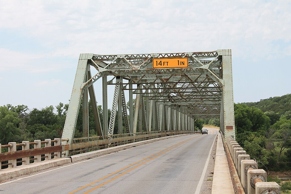
Photograph of US 281 Bridge at the Brazos River
Photograph by Renelibrary, CC BY-SA 3.0. Via Wikimedia Commons.

US 281 Bridge at the Brazos River

Listed on the National Register of Historic Places in 1996.

From the record

“US 281 Bridge at the Brazos River refers to two bridges located south of Mineral Wells, Texas. Route 281 (US 281) across the Brazos River.”

Wikipedia article US 281 Bridge at the Brazos River, CC BY-SA 4.0.

One of 11 National Register listings published here for Palo Pinto County · listed in 1996 · category: Structure.

Sources: the Wikipedia article · the case file at the National Archives · the National Register database, National Park Service

The listing

  • What is counted as historic. The nomination lists 1 structure as contributing to the listing.
  • Address. US 281, 2.2 mi. N of I-20, Santo, 76472
  • When was it listed? October 1996
  • Category. structure
  • Also known as. Historic Bridges of Texas MPS
  • Census division. Palo Pinto-Santo
  • National Register reference number. 96001126 - the number the National Park Service assigned this property when it was listed, and the key its nomination file is catalogued under at the National Archives.

Fires near this property

200 since 2005

Regional context, not property-specific evidence. The federal wildfire occurrence database lists 200 fires within 5 miles of US 281 Bridge at the Brazos River between 2005 and 2020, burning about 2,082 acres in total. 5 started naturally. 2 were recorded as arson. Distance is straight-line from the map coordinates, so a fire counted here may appear on a neighbouring settlement's page as well.

Reported cause Fires
Debris and open burning85
Equipment and vehicle use56
Missing data/not specified/undetermined35
Smoking5
Natural5
Railroad operations and maintenance5
Power generation/transmission/distribution4
Recreation and ceremony3
Arson/incendiarism2

The most recent of them, most recent first, with the day each was reported and the service that recorded it.

DateCause SizeReported by Name on the report
9 September 2008Equipment and vehicle use100 acresTexas A & M Forest Servicenot named
8 September 2019Missing data/not specified/undetermined3.0 acresTexas A & M Forest Service129 FIRE
8 September 2019Debris and open burning2.0 acresTexas A & M Forest Service1307 FM 129
7 September 2016Debris and open burning1.0 acresTexas A & M Forest ServiceTILLMAN FIRE 16-195
6 September 2010Equipment and vehicle use4.0 acresTexas A & M Forest ServiceDOBBS VALLEY FIRE #1
5 September 2008Debris and open burning25 acresTexas A & M Forest Servicenot named
30 September 2013Debris and open burning1.0 acresTexas A & M Forest ServiceWALKER LANE

Every fire recorded in Palo Pinto County

Mines and quarries near this property

1 within 5 miles

Regional context, not property-specific evidence. The federal mineral resources record lists 1 working within 5 miles of US 281 Bridge at the Brazos River: 1 producer. All of them still produce. What was taken out: Sand and Gravel, Construction, Stone, Crushed/Broken. Distance is straight-line from the map coordinates, so a quarry counted here may appear on a neighbouring settlement's page as well.

Where SiteCommodity StatusRecorded
Texoline QuarrySand and Gravel, Construction, Stone, Crushed/BrokenProducer

Every working recorded in Palo Pinto County

Storms near this property

39 since 1994

Regional context, not property-specific evidence. The National Weather Service names Santo, the town this property stands in, in 39 storm reports between 1994 and 2025: 16 hail, 10 thunderstorm wind, 6 tornado, 5 flood. No death or injury is recorded in these reports. Each account below is quoted exactly as the forecast office filed it, from the NOAA Storm Events Database, and each date opens the federal record of that event.

WhenEvent Place namedHarm What the report says
May 2016FloodSanto$100,000Several roads across the southern portions of the county remained closed due to flooding. Areas affected included Mingus, Strawn, Gordon, and other areas along Palo Pinto Creek. The flooding continued into June 1st.
May 2025Thunderstorm WindSanto$20,000Very strong inbound winds into a tornadic supercell produced widespread tree damage along FM 2201 and into Santo. A light pole at the athletic field was also bent, and some minor roof damage was also observed in Santo.
April 2015Flash FloodSanto$20,000Water was reported over several roads in and around Santo; including FM 2201. Flooding was also reported on FM 2692 going towards Gordon.
April 2012HailSanto$20,000Ping pong ball sized hail was reported 5 miles east of Gordon near Interstate 20.
April 2016FloodSanto$10,000Several roads remained flooded after up to 6 inches of rain fell across the county. Most of the flooding was near creeks and streams and in low lying areas. Flooding continued on Highway 281 near Mineral Wells, and one high water rescue was reported on FM 4 south of Lone Camp in a low water crossing.
April 2008Tornado (EF0)Santo$10,000The Erath County tornado continued into Palo Pinto County. Tree and sporadic roof damage occurred across FM 2603 to near the intersection of FM 4 and Highway 281 in southeastern Palo Pinto County. This tornado was rated an EF-0 with maximum winds between 80 and 85 MPH.
May 2025HailSanto$7,000Golf ball sized hail was reported near I-20 at mile marker 384.
March 2022Thunderstorm WindSanto$5,000Emergency management reported minor roof and siding damage to a single family residence in the city of Santo.
August 2003Thunderstorm WindSanto$5,000A 2 foot diameter oak tree was blown down at the stadium and numerous 8 to 10 inch diameter limbs broken. Light poles at the stadium were also blown down.
February 2001Thunderstorm WindSanto$5,000A trailer was heavily damaged by high thunderstorm winds.
June 1994Thunderstorm WindSanto$5,000Power lines and trees were blown down, and minor roof damage occurred due to thunderstorm winds.
May 2011HailSanto$3,000no account filed
June 2025Flash FloodSanto$1,000Flash flooding was reported on Blue Flat Road just west of the Interstate 20 Santo exit.
March 2003Tornado (F0)Santo$1,000Some cattle feeders were damaged by a brief tornado touchdown.
September 2001Thunderstorm WindSanto$500Power lines were blown down at the intersection of Highway 281 and Highway 4.
March 2025HailSanto-Social media photo showed half dollar sized hail 3 miles north of Santo.
May 2025HailSanto-Report from mPING: Quarter (1.00 in.).
May 2025Tornado (EF0)Santo-Storm chaser and spotter videos of a rapidly cyclic, multi-vortex tornado was confirmed by scattered tree damage along a path that stretched from Panama Road southwest of Santo to FM 4 south of Santo. For the most part, each of the vortices were relatively shorted-lived, lasting from just a few seconds to up to 30 seconds. At one point, two vortices near FM 4 appeared to nearly rotate around each other before they dissipated. Based on the observed tree damage, this tornado was rated an EF-0 multi-vortex tornado with maximum estimated winds of 80 mph.
May 2025Tornado (EFU)Santo-Right after the multi-vortex tornado south of Santo, chaser videos showed an additional, larger tornado forming east of FM 4. Damage from this tornado was not found. This tornado will be rated an EF-Unknown, and its location is estimated based on radar and video.
March 2022Thunderstorm WindSanto-The fire chief in Santo, TX reported several 8 to 10 inch tree limbs down by the high school gym on Bowie Street.
December 2022Tornado (EF1)Santo-An EF-1 tornado affected southeastern Palo Pinto County near Santo. The tornado touched down near the intersection of South Bosley Road and Single Oak Lane where tree damage and minor roof damage was noted. The tornado then moved northeast, crossing Highway 281 towards Live Oak Road where it produced damage to numerous outbuildings, including the complete destruction of a small home gym. The tornado lifted east of Live Oak Road. Maximum estimated winds were 110 MPH.
May 2019Tornado (EFU)Santo-A brief tornado occurred north of Lipan, TX and southeast of Santo, TX. Vegetation debris was observed in real-time.
May 2018HailSanto-Large hail reported on the east side of Lake Palo Pinto.
May 2016HailSanto-A public report estimated quarter-sized hail approximately 5 miles south of Santo, TX.
June 2016FloodSanto-Several roads across the southern portions of the county remained closed due to flooding that began on May 31st. Areas affected included Mingus, Strawn, Gordon, and other areas along Palo Pinto Creek. House water rescues along the creek were still ongoing on the morning of June 1st.
March 2016FloodSanto-Palo Pinto County Sheriff's Department reported that many roads remained closed in the southern and eastern portions of the county.
March 2013HailSanto-Nickel sized hail was reported approximately 3 miles west of the intersection of I-20 and U.S. Highway 281.
March 2013HailSanto-Nickel sized hail was reported near the intersection of FM 4 and FM129.
January 2012FloodSanto-A trained spotter reported than a foot of water was flowing over FM 4 at Buck Creek. This location is in the far southern portion of the county, south of Santo.
April 2011HailSanto-Ping pong ball size hail fell 2 miles west of Lipan.
September 2001Thunderstorm WindSanto-A highway sign was blown down at the intersection of Interstate 20 and Highway 4.
May 1995HailSanto-Two men had to be rescued after driving into high water where Farm to Market Road 4 crossed a rain swollen creek.
June 2023HailSanto-no account filed
March 2003HailSanto-no account filed
October 1998HailSanto-no account filed
March 1997HailSanto-no account filed
June 1996Thunderstorm WindSanto-no account filed
September 1996HailSanto-no account filed

Every storm recorded in Palo Pinto County

Map coverage status

No historic map-sheet match is published for this property yet. That does not mean no map exists. This record needs a coordinate-quality review before it can be joined to a sheet boundary. Browse the county's mapped places while that work is pending.

Sources for this property

National Archives recordThe nomination case file for reference 96001126 in Record Group 79.
Wikipedia articleCommunity-written account of this property, licensed CC BY-SA.
Palo Pinto CountyAll 11 listed properties in this county.

Provenance

  • Listing record. National Park Service National Register of Historic Places, listed-properties dataset, current to 2026-05-22.
  • Map join. Address geocoded through the United States Census geocoder, then tested against the published boundary of every sheet in the USGS Historical Topographic Map Collection.
  • How this page is made. Listing fields come from federal records; map-sheet coverage is a labelled coordinate-to-boundary calculation, not a source-field claim.
  • Wildfire. Short, Karen C. 2022. Spatial wildfire occurrence data for the United States, 1992-2020 [FPA_FOD_20221014]. 6th Edition. Fort Collins, CO: Forest Service Research Data Archive. https://doi.org/10.2737/RDS-2013-0009.6 Collected with United States Government funding and usable without additional permissions or fees.
  • Mines and quarries. USGS Mineral Resources Data System (MRDS) https://mrdata.usgs.gov/mrds/ A work of the United States government, no copyright under 17 U.S.C. 105.
  • Storms. NOAA National Centers for Environmental Information, Storm Events Database https://www.ncei.noaa.gov/stormevents/ A work of the United States government, no copyright under 17 U.S.C. 105. Narratives are quoted verbatim from the National Weather Service report and are not edited or summarised.