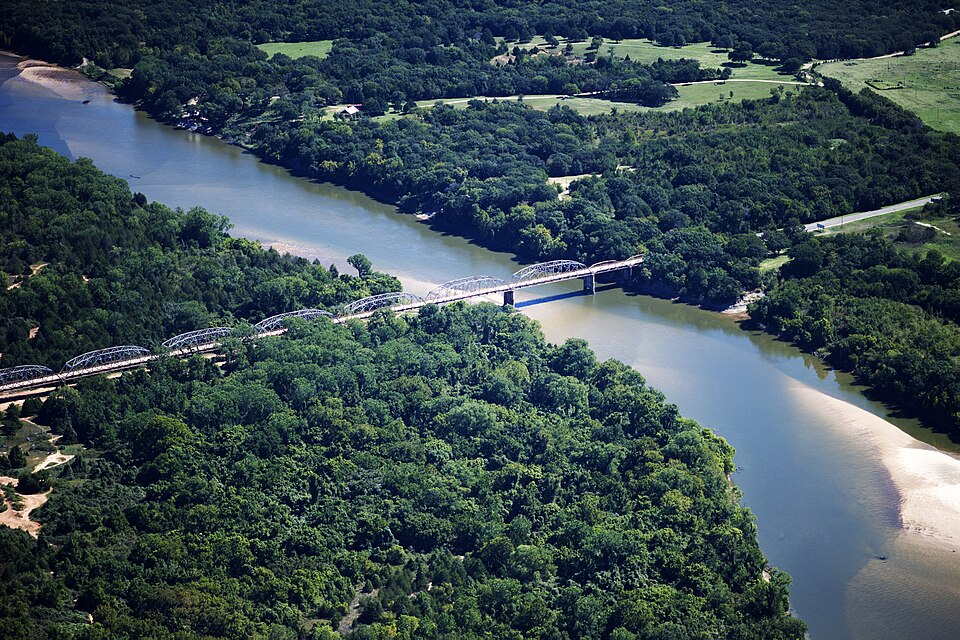
Listed on the National Register of Historic Places in 1996.
From the record
“The Highway 78 Bridge at the Red River is an eight-span through truss bridge over the Red River between Oklahoma and Texas on Oklahoma State Highway 78/Texas State Highway 78. It was built as a federal relief project during the Great Depression as part of President Franklin Roosevelt's New Deal.”
Wikipedia article State Highway 78 Bridge at the Red River, CC BY-SA 4.0.
One of 10 National Register listings published here for Fannin County · listed in 1996 · category: Structure.
National Register reference number.96001517- the number the National Park Service assigned this property when it was listed, and the key its nomination file is catalogued under at the National Archives.
Fires near this property
61 since 1998
Regional context, not property-specific
evidence. The
federal wildfire occurrence database
lists 61 fires within 5 miles of State Highway 78 Bridge at the Red River
between 1998 and 2020, burning about 902 acres in total. 2 started naturally. 5 were recorded as arson.
Distance is straight-line from the map coordinates, so a fire counted
here may appear on a neighbouring settlement's page as well.
Reported cause
Fires
Debris and open burning
27
Missing data/not specified/undetermined
14
Equipment and vehicle use
10
Arson/incendiarism
5
Power generation/transmission/distribution
2
Natural
2
Smoking
1
The most recent of
them, most recent first, with the day each was reported and the service
that recorded it.
Regional context, not property-specific
evidence. The federal mineral resources record lists
3 workings within 5 miles of State Highway 78 Bridge at the Red River: 2 past producers, 1 producer.
1 still produces. What was taken out: Sand and Gravel, Construction. Distance is straight-line from the
map coordinates, so a quarry counted here may appear on a neighbouring
settlement's page as well.
Regional context, not property-specific
evidence. The National Weather Service names
Ravenna, the town this property stands in, in 18 storm reports between 1994 and 2025: 12 hail, 4 thunderstorm wind, 1 lightning, 1 tornado.
No death or injury is recorded in these reports. Each account below is quoted exactly as the forecast office
filed it, from the NOAA Storm Events Database, and each date
opens the federal record of that event.
The same parent storm that produced the Ravenna tornado also spawned another EF-1 tornado that touched down along FM 274 around 2 miles south of Ravenna, causing minor damage to a home and blowing down a few trees. The tornado intensified as it continued southeast, blowing down numerous trees in rural areas east of FM 274 and north of FM 898. Southwest of the tornado path, RFD or inflow winds into the tornado blew down many more trees along FM 274 and FM 898 west of CR 1444. As the tornado crossed FM 898 near CR 1445, a few homes suffered minor exterior damage, some outbuildings were heavily damaged, and many large trees were snapped or uprooted. A small silo along CR 1445 was lifted and blown 350 yards to the southeast before landing. Notable cyclonic patterns were also apparent in flattened grass in this area. The tornado weakened as it crossed US 82 and Hwy 121, knocking down just a few trees, causing very minor damage to a Fix & Feed store, and blowing a few sheds into a field. As the tornado entered the city of Bonham, it intensified again and blew down hundreds of trees along residential streets in the northwest part of the city. Three homes along Agnew Street suffered heavy wind damage (where the maximum estimated winds of 100 mph occurred), a church on Franklin Ave lost its steeple, and another church on Oriental Street lost an exterior wall. The tornado continued through the southeast part of town causing more sporadic damage before it dissipated just past Carpenter Loop. Maximum estimated winds were 100 mph.
Emergency management officials reported a lightning strike on a house in Ravenna, resulting in a minor fire. Additionally, three other lightning strikes were reported, causing small grass fires in the Ector and Ladonia areas.
Emergency management reported wind damage along Highway 274 north of Ravenna, TX, including large tree limbs broken, metal buildings damaged, minor roof damage and a power pole broken.
A storm survey team determined RFD or inflow winds along the west side of a tornado track caused notable tree damage and some structural damage along FM 274 and West FM 898 between Ravenna and Bonham.
No historic map-sheet match is published
for this property yet. That does not mean no map exists. This record needs
a coordinate-quality review before it can be joined to a sheet boundary.
Browse the county's mapped places while that work is
pending.
Listed places nearby
1 within 8 miles
Other National Register properties close
enough to walk or drive between, ordered by distance from this one. Both
positions come from the same geocoding pass that matched these properties
to their map sheets.
Listing record. National Park Service National Register of Historic Places, listed-properties dataset, current to 2026-05-22.
Map join. Address geocoded through the United States Census geocoder, then tested against the published boundary of every sheet in the USGS Historical Topographic Map Collection.
How this page is made. Listing fields come from federal records; map-sheet coverage is a labelled coordinate-to-boundary calculation, not a source-field claim.
Wildfire. Short, Karen C. 2022. Spatial wildfire occurrence data for the United States, 1992-2020 [FPA_FOD_20221014]. 6th Edition. Fort Collins, CO: Forest Service Research Data Archive. https://doi.org/10.2737/RDS-2013-0009.6 Collected with United States Government funding and usable without additional permissions or fees.
Mines and quarries. USGS Mineral Resources Data System (MRDS) https://mrdata.usgs.gov/mrds/ A work of the United States government, no copyright under 17 U.S.C. 105.
Storms. NOAA National Centers for Environmental Information, Storm Events Database https://www.ncei.noaa.gov/stormevents/ A work of the United States government, no copyright under 17 U.S.C. 105. Narratives are quoted verbatim from the National Weather Service report and are not edited or summarised.
 Block
Block