
BlockBefore
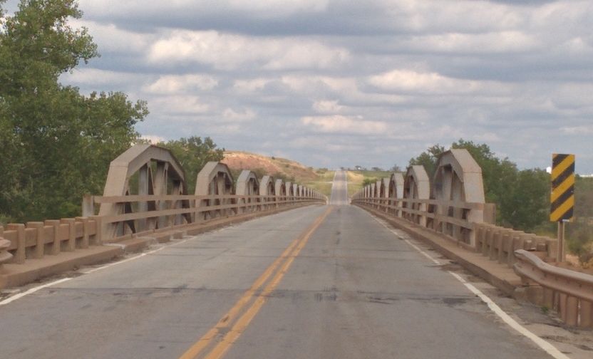
Photograph of State Highway 79 Bridge at the Red River
Photograph by Crimsonedge34, CC BY-SA 3.0. Via Wikimedia Commons.

State Highway 79 Bridge at the Red River

Listed on the National Register of Historic Places in 1996.

From the record

“The State Highway 79 Bridge at the Red River was a bridge carrying Texas State Highway 79 and Oklahoma State Highway 79 over the Red River at the Texas-Oklahoma state line. The camelback pony truss bridge was 2,255 feet (687 m) long and had 21 truss spans.”

Wikipedia article State Highway 79 Bridge at the Red River, CC BY-SA 4.0.

One of 3 National Register listings published here for Clay County · listed in 1996 · category: Structure.

Sources: the Wikipedia article · the case file at the National Archives · the National Register database, National Park Service

The listing

  • What is counted as historic. The nomination lists 2 structuress as contributing to the listing.
  • Address. OK 79 across the Red River at the OK-TX state line, Byers, 76357
  • When was it listed? December 1996
  • Category. structure
  • Also known as. Historic Bridges of Texas MPS
  • Census division. Byers-Petrolia
  • National Register reference number. 96001518 - the number the National Park Service assigned this property when it was listed, and the key its nomination file is catalogued under at the National Archives.

Fires near this property

19 since 2009

Regional context, not property-specific evidence. The federal wildfire occurrence database lists 19 fires within 5 miles of State Highway 79 Bridge at the Red River between 2009 and 2020, burning about 476 acres in total. None started naturally. 1 was recorded as arson. Distance is straight-line from the map coordinates, so a fire counted here may appear on a neighbouring settlement's page as well.

Reported cause Fires
Missing data/not specified/undetermined10
Equipment and vehicle use6
Recreation and ceremony2
Arson/incendiarism1

The most recent of them, most recent first, with the day each was reported and the service that recorded it.

DateCause SizeReported by Name on the report
31 August 2015Equipment and vehicle useunder an acreTexas A & M Forest Service8/7/2015
28 August 2020Equipment and vehicle use1.0 acresTexas A & M Forest ServiceMCGEE FIRE
28 August 2020Equipment and vehicle use2.0 acresTexas A & M Forest Service8282020
21 August 2013Missing data/not specified/undetermined1.0 acresTexas A & M Forest ServiceHARDING FIRE M/A BYERS
3 July 2019Missing data/not specified/undeterminedunder an acreTexas A & M Forest ServiceUNKNOWN
27 July 2012Missing data/not specified/undetermined30 acresTexas A & M Forest ServiceMAGEE FIRE
13 July 2019Missing data/not specified/undeterminedunder an acreTexas A & M Forest ServiceUNKNOWN
13 July 2014Missing data/not specified/undetermined1.0 acresTexas A & M Forest ServiceRIVER GRASS FIRE

Every fire recorded in Clay County

Mines and quarries near this property

8 within 5 miles

Regional context, not property-specific evidence. The federal mineral resources record lists 8 workings within 5 miles of State Highway 79 Bridge at the Red River: 6 occurrences, 2 past producers. None of them still produces. What was taken out: Copper, Manganese, Copper, Manganese, Sand and Gravel, Construction. Distance is straight-line from the map coordinates, so a quarry counted here may appear on a neighbouring settlement's page as well.

Where SiteCommodity StatusRecorded
Unknown Sand and Gravel PitSand and Gravel, ConstructionPast Producer
Uranium ProspectUraniumOccurrence
Waurika West-3Copper, ManganeseOccurrence1940
Unnamed ProspectManganeseOccurrence1941
Miller ProspectCopperPast Producer1913, 1934
Waurika West-1CopperOccurrence1932
Waurika West-2CopperOccurrence1932

Every working recorded in Clay County

Storms near this property

22 since 1993

Regional context, not property-specific evidence. The National Weather Service names Byers, the town this property stands in, in 22 storm reports between 1993 and 2026: 15 hail, 5 thunderstorm wind, 2 tornado. No death or injury is recorded in these reports. Each account below is quoted exactly as the forecast office filed it, from the NOAA Storm Events Database, and each date opens the federal record of that event.

WhenEvent Place namedHarm What the report says
May 2006Thunderstorm WindByers$150Several tree limbs were downed.
April 2026HailByers-The report was relayed through mPING.
March 2024HailByers-Relayed report via amateur radio.
November 2024Tornado (EF1)Byers-A storm chaser observed a tornado at times across northeastern Clay County. The tornado initially developed south of Byers and moved north and then northeast into the far northeastern edge of Clay County dissipating near the Red River. The tornado may have extended into Jefferson County Oklahoma, but no evidence could be found on the Oklahoma side of the Red River.||At least two homes experienced significant roof damage, a couple of barns were significantly damaged and a few large trees were snapped or uprooted.
May 2017Thunderstorm WindByers-Power lines downed on highway 79 between Patrolia and Byers.
May 2015Tornado (EF0)Byers-Spotters observed a multiple-vortex tornado believed to be south of the Red River approximately 4 miles south of Ryan OK. No damage was reported.
May 2015HailByers-No damage reported.
June 1998Thunderstorm WindByers-Numerous large tree limbs were blown down by winds estimated at 65 mph.
July 1994HailByers-Thunderstorms in the western part of north Texas during the evening hours of the 7th produced hail up to nickel-size and damaging winds. Thunderstorm winds uprooted trees and broke off tree limbs in Byers and damaged a mobile home just east of Byers.
July 1994Thunderstorm WindByers-Thunderstorms in the western part of north Texas during the evening hours of the 7th produced hail up to nickel-size and damaging winds. Thunderstorm winds uprooted trees and broke off tree limbs in Byers and damaged a mobile home just east of Byers.
March 2018HailByers-no account filed
March 2013HailByers-no account filed
May 2012HailByers-no account filed
April 2004HailByers-no account filed
May 2001HailByers-no account filed
June 1995HailByers-no account filed
August 1994Thunderstorm WindByers-no account filed
August 1994HailByers-no account filed
March 1993HailByers-no account filed

Every storm recorded in Clay County

Map coverage status

No historic map-sheet match is published for this property yet. That does not mean no map exists. This record needs a coordinate-quality review before it can be joined to a sheet boundary. Browse the county's mapped places while that work is pending.

Sources for this property

National Archives recordThe nomination case file for reference 96001518 in Record Group 79.
Wikipedia articleCommunity-written account of this property, licensed CC BY-SA.
Clay CountyAll 3 listed properties in this county.

Provenance

  • Listing record. National Park Service National Register of Historic Places, listed-properties dataset, current to 2026-05-22.
  • Map join. Address geocoded through the United States Census geocoder, then tested against the published boundary of every sheet in the USGS Historical Topographic Map Collection.
  • How this page is made. Listing fields come from federal records; map-sheet coverage is a labelled coordinate-to-boundary calculation, not a source-field claim.
  • Wildfire. Short, Karen C. 2022. Spatial wildfire occurrence data for the United States, 1992-2020 [FPA_FOD_20221014]. 6th Edition. Fort Collins, CO: Forest Service Research Data Archive. https://doi.org/10.2737/RDS-2013-0009.6 Collected with United States Government funding and usable without additional permissions or fees.
  • Mines and quarries. USGS Mineral Resources Data System (MRDS) https://mrdata.usgs.gov/mrds/ A work of the United States government, no copyright under 17 U.S.C. 105.
  • Storms. NOAA National Centers for Environmental Information, Storm Events Database https://www.ncei.noaa.gov/stormevents/ A work of the United States government, no copyright under 17 U.S.C. 105. Narratives are quoted verbatim from the National Weather Service report and are not edited or summarised.