 Block
From the record
One of 17 National Register listings published here for Uintah County · listed in 1975 · category: Site.
Sources: the case file at the National Archives · the National Register database, National Park Service
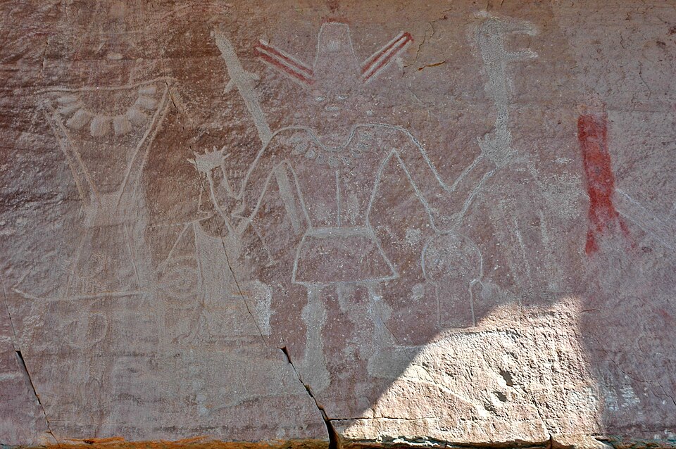
Listed on the National Register of Historic Places in 1975.
One of 17 National Register listings published here for Uintah County · listed in 1975 · category: Site.
Sources: the case file at the National Archives · the National Register database, National Park Service
Regional context, not property-specific evidence. The federal wildfire occurrence database lists 120 fires within 5 miles of McConkie Ranch Petroglyphs between 1992 and 2020, burning about 6,084 acres in total. 76 started naturally. None was recorded as arson. Distance is straight-line from the map coordinates, so a fire counted here may appear on a neighbouring settlement's page as well.
| Reported cause | Fires |
|---|---|
| Natural | 76 |
| Missing data/not specified/undetermined | 27 |
| Debris and open burning | 7 |
| Recreation and ceremony | 5 |
| Equipment and vehicle use | 3 |
| Fireworks | 1 |
| Power generation/transmission/distribution | 1 |
The most recent of them, most recent first, with the day each was reported and the service that recorded it.
| Date | Cause | Size | Reported by | Name on the report |
|---|---|---|---|---|
| 7 September 1993 | Missing data/not specified/undetermined | under an acre | Utah Division Forestry Fire State Lands | DRY FORK |
| 4 September 1993 | Natural | under an acre | Vernal Field Office | TWELVEMILE |
| 4 September 1993 | Natural | under an acre | Vernal Field Office | SHINDY |
| 30 September 1998 | Natural | under an acre | Vernal Field Office | LITTLE MTN |
| 3 September 1993 | Missing data/not specified/undetermined | under an acre | Utah Division Forestry Fire State Lands | LITTLE MTN |
| 25 September 1993 | Missing data/not specified/undetermined | under an acre | Utah Division Forestry Fire State Lands | SHINDY DRAW |
| 24 September 1993 | Missing data/not specified/undetermined | under an acre | Utah Division Forestry Fire State Lands | STEINAKER DRAW |
| 23 September 1993 | Missing data/not specified/undetermined | 1.0 acres | Utah Division Forestry Fire State Lands | DRY FORK SETTLEMENT |
Regional context, not property-specific evidence. The federal mineral resources record lists 8 workings within 5 miles of McConkie Ranch Petroglyphs: 5 prospects, 2 plants, 1 occurrence. 2 still produce. What was taken out: Phosphorus-Phosphates, Gypsum-Anhydrite, Uranium. Distance is straight-line from the map coordinates, so a quarry counted here may appear on a neighbouring settlement's page as well.
| Where | Site | Commodity | Status | Recorded |
|---|---|---|---|---|
| Vernal Field Combined | Phosphorus-Phosphates, Uranium | Prospect | 1914 | |
| Steinaker Draw Gypsum Deposit | Gypsum-Anhydrite | Occurrence | Gypsum | |
| Steinaker Draw Gypsum Deposit | Gypsum-Anhydrite | Prospect | ||
| Vernal Field #1 | Phosphorus-Phosphates | Plant | 1914 | |
| Vernal Field #2 | Phosphorus-Phosphates | Plant | 1914 | |
| Vernal Field #3 | Phosphorus-Phosphates | Prospect | 1914 | |
| Vernal Field #4 | Phosphorus-Phosphates | Prospect | 1914 | |
| Vernal Field #5 | Phosphorus-Phosphates | Prospect | 1914 |
Regional context, not property-specific evidence. The National Weather Service names Vernal, the town this property stands in, in 27 storm reports between 1993 and 2023: 10 hail, 6 thunderstorm wind, 4 flash flood, 2 tornado. No death or injury is recorded in these reports. Each account below is quoted exactly as the forecast office filed it, from the NOAA Storm Events Database, and each date opens the federal record of that event.
| When | Event | Place named | Harm | What the report says |
|---|---|---|---|---|
| May 1997 | Flash Flood | Vernal | $100,000 | no account filed |
| August 1999 | Thunderstorm Wind | Vernal | $30,000 | no account filed |
| September 2013 | Hail | Vernal | $20,000 | Large hail flattened gardens, dented a number of vehicles, and broke some windows. |
| August 2009 | Tornado (EF0) | Vernal | $1,000 | A tornado tracked through a small section of Vernal, mostly staying between houses. A number of trees had large limbs broken off and some minor damage occurred to sheds. The tornado was seen by many area residents and photographed by at least three persons. |
| July 1998 | Flash Flood | Vernal | $1,000 | no account filed |
| July 2023 | Thunderstorm Wind | Vernal | - | A peak wind gust of 68 MPH was measured by the automated weather station at the Vernal Regional Airport. |
| July 2020 | Thunderstorm Wind | Vernal | - | A peak wind gust of 59 mph was measured by the automated weather station at the Vernal Regional Airport. |
| August 2018 | Hail | Vernal | - | Multiple trained spotters and members of the public observed nickel-sized hail in Vernal, mainly in the northwest portion of the city and in the downtown area. |
| September 2013 | Hail | Vernal | - | Hail accumulated up to two inches deep on Highway 191 and minor flooding was reported in the area. |
| June 2010 | Hail | Vernal | - | Hail up to 1 inch in diameter was reported. |
| June 2010 | Hail | Vernal | - | Hail up to 1.25 inches in diameter pummelled the area. |
| October 1994 | Hail | Vernal | - | A thunderstorm dropped 0.75-inch diameter hail at Ashley Creek. Larger hail was observed but not measured. |
| May 1993 | Tornado (F0) | Vernal | - | The cold upper low previously mentioned moved over northeast Utah by the early evening hours of the 5th. This produced a cold core funnel cloud. This was one of the rare occasions that a cold core funnel cloud became a tornado. The tornado was spotted by an airplane. Because the tornado only lasted a few minutes, and was in a sparsely populated region of the state, it caused no damage. |
| September 2013 | Hail | Vernal | - | no account filed |
| September 2013 | Hail | Vernal | - | no account filed |
| September 2013 | Hail | Vernal | - | no account filed |
| May 2006 | Thunderstorm Wind | Vernal | - | no account filed |
| September 2006 | Heavy Rain | Vernal | - | no account filed |
| May 2003 | Hail | Vernal | - | no account filed |
| August 2002 | Wildfire | Vernal | - | no account filed |
| July 2002 | Flash Flood | Vernal | - | no account filed |
| May 2000 | Thunderstorm Wind | Vernal | - | no account filed |
| September 1999 | Funnel Cloud | Vernal | - | no account filed |
| August 1999 | Funnel Cloud | Vernal | - | no account filed |
| July 1998 | Heavy Rain | Vernal | - | no account filed |
| August 1997 | Flash Flood | Vernal | - | no account filed |
| July 1995 | Thunderstorm Wind | Vernal | - | no account filed |
No historic map-sheet match is published for this property yet. That does not mean no map exists. This record needs a coordinate-quality review before it can be joined to a sheet boundary. Browse the county's mapped places while that work is pending.
Other National Register properties close enough to walk or drive between, ordered by distance from this one. Both positions come from the same geocoding pass that matched these properties to their map sheets.
| Photograph | Property | Distance | Listed |
|---|---|---|---|
 | Smith, Francis 'Frank' and Eunice, House | 5.9 miles | 2001 |
 | Gibson-Sowards House | 6.4 miles | 1997 |
 | William and Emily Siddoway House | 7.9 miles | 2006 |
| National Archives record | The nomination case file for reference 75001828 in Record Group 79. |
| Uintah County | All 17 listed properties in this county. |