 Block
From the record
One of 20 National Register listings published here for Grand County · listed in 1984 · category: Structure · built in 1916.
Sources: the case file at the National Archives · the National Register database, National Park Service
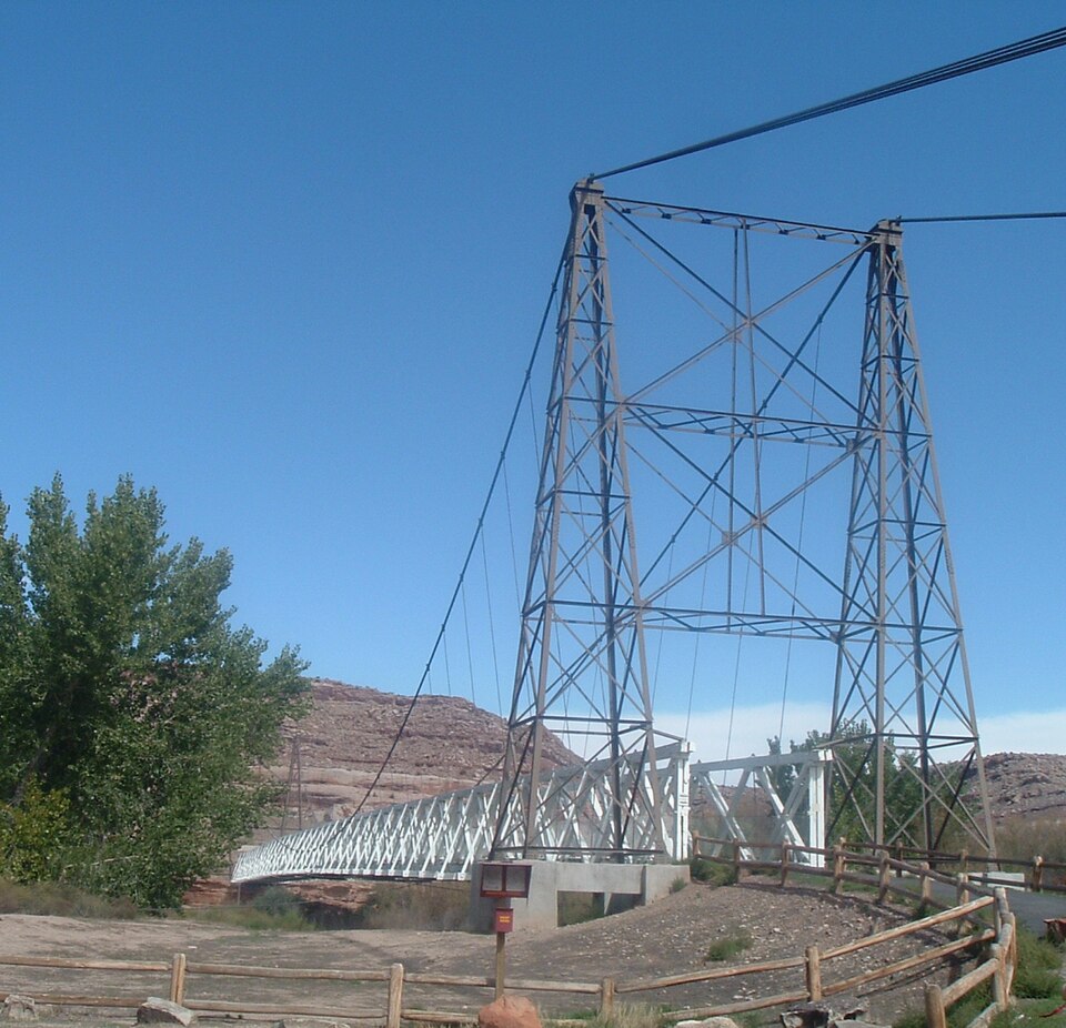
Built in 1916. Listed on the National Register of Historic Places in 1984.
One of 20 National Register listings published here for Grand County · listed in 1984 · category: Structure · built in 1916.
Sources: the case file at the National Archives · the National Register database, National Park Service
Regional context, not property-specific evidence. The federal wildfire occurrence database lists 27 fires within 5 miles of Dewey Bridge between 1992 and 2016, burning about 170 acres in total. 9 started naturally. 1 was recorded as arson. Distance is straight-line from the map coordinates, so a fire counted here may appear on a neighbouring settlement's page as well.
| Reported cause | Fires |
|---|---|
| Natural | 9 |
| Missing data/not specified/undetermined | 9 |
| Recreation and ceremony | 3 |
| Misuse of fire by a minor | 2 |
| Debris and open burning | 2 |
| Arson/incendiarism | 1 |
| Power generation/transmission/distribution | 1 |
The most recent of them, most recent first, with the day each was reported and the service that recorded it.
| Date | Cause | Size | Reported by | Name on the report |
|---|---|---|---|---|
| 25 September 2002 | Missing data/not specified/undetermined | under an acre | Moab Field Office | RIVERSIDE |
| 2 September 2011 | Natural | under an acre | Moab Field Office | COTTONWOOD RANCH |
| 14 September 1994 | Natural | under an acre | Moab Field Office | BIG PINTO |
| 1 September 2015 | Natural | under an acre | Moab Field Office | DEWEY |
| 1 September 2001 | Natural | under an acre | Moab Field Office | SCRUFFS |
| 30 August 1992 | Missing data/not specified/undetermined | under an acre | Utah Division Forestry Fire State Lands | DEWEY COTTONWOOD |
| 19 August 1998 | Missing data/not specified/undetermined | under an acre | Moab Field Office | SECTION 13 |
| 9 July 1994 | Missing data/not specified/undetermined | under an acre | Utah Division Forestry Fire State Lands | PROUD FOOT BEND |
Regional context, not property-specific evidence. The federal mineral resources record lists 40 workings within 5 miles of Dewey Bridge: 16 producers, 12 occurrences, 9 past producers, 3 prospects. 16 still produce. What was taken out: Uranium, Uranium, Vanadium, Vanadium, Gold. Distance is straight-line from the map coordinates, so a quarry counted here may appear on a neighbouring settlement's page as well.
| Where | Site | Commodity | Status | Recorded |
|---|---|---|---|---|
| Ringtail Mine | Vanadium, Uranium | Producer | ||
| Manganese Prospect | Manganese | Occurrence | Replacement | |
| Squaw Park Deposit | Manganese | Prospect | 1952 | |
| Dewey Gravel Pit | Sand and Gravel, Construction | Past Producer | Unconsolidated Sediments | |
| Dewey Gravel Pit | Sand and Gravel, Construction | Producer | ||
| Hittle Bottom | Gold | Past Producer | Placer | |
| Mouth of Dolores River | Gold | Past Producer | Placer | |
| Unknown | Sand and Gravel, Construction | Past Producer | Unconsolidated Sediments | |
| Unknown | Gold | Occurrence | Placer | |
| Unknown #1 | Sand and Gravel, Construction | Producer |
Regional context, not property-specific evidence. The National Weather Service names Moab, the town this property stands in, in 94 storm reports between 1996 and 2025: 38 flash flood, 14 heavy rain, 11 hail, 9 flood. The reports record 3 deaths. Each account below is quoted exactly as the forecast office filed it, from the NOAA Storm Events Database, and each date opens the federal record of that event.
| When | Event | Place named | Harm | What the report says |
|---|---|---|---|---|
| June 2024 | Flash Flood | Moab | 2 killed | Major flooding in Moab and Castle Valley from strong thunderstorm that produced very heavy rain across town, Mill Creek, North Mill Creek, Kane Creek and a drainage above Castle Valley. 1 inch of rain fell in 15 minutes for a rainrate of 4 inches per hour. 2 reported missing in Moab area with an abandoned vehicle discovered in Mill Creek drainage after flash flooding, 1 was found deceased and other assumed fatality but not found. |
| August 1996 | Lightning | Moab | 1 killed | no account filed |
| August 2022 | Flash Flood | Moab | $9,500,000 | Training thunderstorms produced upwards of 1 to 2 inches of rain within one to two hours in an around Moab. The Mill Creek Parkway - a recreational path that runs through the center of Moab, was reported to be completely decimated as a result of the flooding. Several areas had their water turned off after flood waters led to a broken water main. Numerous homes and businesses had upwards of 12 inches of water and debris inside resulting in significant property damage. |
| July 2021 | Flash Flood | Moab | $2,500,000 | Heavy rain led to flash flooding in downtown Moab. |
| October 2006 | Flood | Moab | $500,000 | Persistent moderate to heavy rainfall resulted in widespread flooding and flash flooding across much of east central Utah, including Arches National Park. One park ranger said it was the worst flooding she had seen in Arches in 14 years. In the Park, Courthouse Wash ran 12 to 14 feet deep. Roads were closed and washed out in some areas, while some trails were obliterated. The trailhead of Delicate Arch was impassable as flood waters from Salt Wash created a 50 to 60 foot wide channel, blocking pedestrian access. On the evening of Friday, October 6, park employees and Grand County Search And Rescue volunteers ferried 20 adults and 4 children to safety after raging waters in Salt Wash blocked their return from Delicate Arch near the trailhead. Yellow Cat Canyon was hit hard with flooding and it was reported that areas outside the park were a mess. Flood waters did not recede in some areas of the park until Sunday afternoon, October 8. |
| August 2022 | Flash Flood | Moab | $250,000 | Debris from Mill Creek flowed into the Colorado River as a result of heavy rain from thunderstorms. |
| August 2022 | Flash Flood | Moab | $250,000 | Areas along Mill Creek experienced flash flooding as the creek overflowed due to heavy rain from thunderstorms. Water flowed over a park bridge, a dam had damage as an 18 inch diversion pipe cracked and filled with sand, and debris backed up on culverts which resulted in significant overland flooding. |
| September 1997 | Flash Flood | Moab | $175,000 | no account filed |
| July 2000 | Lightning | Moab | $100,000 | no account filed |
| July 1999 | Flash Flood | Moab | $60,000 | no account filed |
| May 2009 | Flash Flood | Moab | $40,000 | Thunderstorms produced heavy rainfall that produced flash flooding off of higher surrounding terrain into the Moab and Spanish Valley areas. Water one to two feet deep flowed rapidly across Highway 191 in the Spanish Valley and closed the highway. Five condos in the Rim Village area had several inches of muddy water seeping into the residences. Twelve people were stranded by falsh flood waters up Millcreek Canyon near Moab and had to be rescued. |
| October 2006 | Flash Flood | Moab | $40,000 | Flash flooding developed from heavy rains in the south end of Moab. Fast moving water up to 2 feet deep flooded roads, including Highway 128 near the ALCO Store. Roads were closed until road graders could remove mud and rocks. The road crossing Onion Creek was also closed due to high water and debris. At least 10 houses had water damage and flooded basements, including a pre-school. One-half inch of rain fell at the fire station between 1100 and 1130 MST, and rainfall was much heavier to the south. |
| September 2017 | Flash Flood | Moab | $30,000 | Heavy rainfall resulted in flash flood waters at least a foot deep which ran down several drainages from the east side of the valley and across Highway 191 into a southern section of Moab. A flood control dam in one of the drainages was destroyed by the flash flooding after it was overtopped. Power House Dam Road was closed due to flood damage and some houses on Holyoak Lane and a couple of businesses incurred some flood damage. The flash flooding deposited a large amount of debris on roads. Rainfall measurements in the southeast area of Moab were up to 0.96 of an inch within about a half hour. |
| August 2021 | Debris Flow | Moab | $25,000 | Water, mud and debris flow from the Pack Creek Fire burn scar reached Spanish Valley as far north as the intersection of Beeman Road and Spanish Valley Road. The culverts were not big enough to hold water. Water, mud and debris went over the road and came into some basements a couple inches deep. |
| November 2014 | Debris Flow | Moab | $25,000 | Heavy rainfall during the months prior to this event resulted in pockets of water in cracks within the sandstone rock formations above the rail line used for the UMTRA superfund hazardous waste removal site just northwest of Moab. A freeze-thaw cycle occurred just prior to a large section of cliff face which broke off and tumbled down onto the railroad tracks and blocked the north portal of the railroad tunnel. Some of the boulders also rolled well beyond the railroad tracks and onto a service road used by the UMTRA project trucks. In addition to a section of railroad track, a gantry crane was also damaged. It took over a month for rock removal and repairs to be completed. During that time, most of the hazardous waste removal activities were suspended. |
| June 2006 | Thunderstorm Wind | Moab | $25,000 | no account filed |
| July 2006 | Flash Flood | Moab | $25,000 | no account filed |
| September 2002 | Flash Flood | Moab | $25,000 | no account filed |
| July 2022 | Flash Flood | Moab | $20,000 | Areas downstream of the Pack Creek Fire burn scar experienced flash flooding as a result of heavy rains over the fire. This included Old City Park Road south of Moab, which had to close due to flooding. |
| October 2006 | Flash Flood | Moab | $20,000 | Heavy rain producing thunderstorms resulted in flash flooding around Moab and Arches National Park. A park ranger reported water two and one-half feet deep in places. Court House Wash and the Yellow Cat area were the hardest hit. Trails and roads in the park became impassable and had to be closed. Campgrounds were flooded and campers and hikers had to be evacuated. Reports from Grand County law enforcement indicated 6 to 12 inches of water running across Highway 191 on the north edge of Moab. |
| October 2006 | Flash Flood | Moab | $15,000 | Washes ran bankfull throughout Arches National Park with numerous reports of flooding and mud and debris flows. The main flooding occurred along Salt Wash and the road to Delicate Arch was washed out. A number of campers and recreationists were evacuated from the park and a few hikers and campers became trapped for a period of time. |
| July 1999 | Heavy Rain | Moab | $10,000 | no account filed |
| October 2022 | Flash Flood | Moab | $5,000 | Numerous roads were closed in Spanish Valley due to flash flooding as a result of heavy rain from thunderstorms. This included Shumway Lane and Old City Park, Floy, Hastings, Sunny Acres, and Kerby Roads. Roads remained closed overnight. The Pack Creek gauge on Pack Creek Road reported a rise of 4 feet when about an inch of rain fell in 90 minutes. |
| July 2022 | Flash Flood | Moab | $5,000 | Areas downstream of the Pack Creek Fire burn scar experienced flash flooding as a result of heavy rains over the fire. This included Sunny Acres Lane north of Spanish Valley, which had to close due to flooding. |
| June 2019 | Thunderstorm Wind | Moab | $5,000 | Collapsing thunderstorms brought strong wind gusts estimated at 75 mph to Moab resulting in trees being blown over and damage to power lines near city hall. |
| September 2025 | Flash Flood | Moab | $3,000 | Kane Creek Boulevard/Kane Springs Road and Potash Road reported as impassable due to flooding and mud on the roadways. |
| September 2005 | Flash Flood | Moab | $3,000 | no account filed |
| May 2023 | Flood | Moab | $2,500 | The Bureau of Land Management reported high flows along the Colorado River near Moab. This led to flooding at the takeout boat ramp near Moab as well as in several campgrounds along the river. This included the King's Bottom, Williams Bottom, Jaycee Park, Hal Canyon, Goose Island, Gold Bar campgrounds as well as the lower section of Drinks Canyon Campground. |
| August 2022 | Flash Flood | Moab | $2,500 | Several side streets and low lying areas flooded along Mill and Pack Creeks as a result of heavy rain over the Pack Creek Fire burn scar. Water ran out of its banks in many spots. The Mill Creek stream gauge in Moab increased by 9 feet in 2 hours. Additionally, areas near Moab reported 0.80 to 1.2 inches of rain. |
| August 2022 | Thunderstorm Wind | Moab | $2,500 | Thunderstorm wind gusts estimated to be between 55-60 mph caused significant roof damage in the Navajo Ridge neighborhood outside Moab. Several solar panels were damaged. |
| July 2017 | Heavy Rain | Moab | $2,000 | Heavy rains impacted the railroad portal at the Moab Uranium Mill Tailings Remedial Action (UMTRA) Project, washing some of the 2014 rock slide trail downslope onto the rails. Additionally, there was also a rock fall about four miles north of the rails that blocked the tracks. Radar estimated at least 1.5 to 2 inches of rain fell across the area that evening. |
| August 2010 | Lightning | Moab | $2,000 | Lightning struck and damaged a power pole south of Kerby Lane on the south side of Moab. This started a grass fire that was quickly suppressed. |
| September 2002 | Thunderstorm Wind | Moab | $2,000 | no account filed |
| July 2000 | Lightning | Moab | $2,000 | no account filed |
| May 2023 | Flood | Moab | $1,000 | Warm temperatures increased snowmelt and caused flooding on the low-lying Stocks Drive near Utah Highway 191. |
| May 2023 | Flood | Moab | $1,000 | Warm temperatures increased snowmelt and caused flooding on the low-lying Sunny Acres Lane, which sits near Pack Creek, near Utah Highway 191. |
| August 2022 | Debris Flow | Moab | $1,000 | Trained spotter reported heavy rain from thunderstorms and measured 1.37 inches in less than an hour. Debris including mud and rocks flowed on nearby portions of Highway 191 in addition to some downed trees branches from strong winds. |
| July 2017 | Flash Flood | Moab | $1,000 | Water flowed up to foot deep across a portion of downtown Moab that resulted in minor damage. Radar rainfall estimates in that area ranged from an inch to an inch and a half. |
| August 2007 | Flash Flood | Moab | $1,000 | Flash flooding occurred along the Salt Wash in Arches National Park. Several inches of water was flowing over a temporary bridge built to replace the original foot bridge destroyed by flooding the previous year. The temporary bridge was damaged and was carried a few feet downstream. Water was also running across the road and parking lot in the Wolfe Ranch area of the Park. Water covered about 30 feet of the road and was up to 2 feet deep. The road leading to Delicate Arch was closed for a period of time as a precaution. |
| July 2007 | Flash Flood | Moab | $1,000 | Heavy rain caused 6 to 12 inches of water to flow across the road near Wolfe Ranch in Arches National Park as Salt Wash came out of its banks. The road was temporarily closed. Flooding also occurred in the visitor center area of Arches National Park where water entered the main visitor center building. |
| April 2000 | Tornado (F0) | Moab | $1,000 | no account filed |
| August 2022 | Flash Flood | Moab | $500 | Several feet of water flowed through a neighborhood in Spanish Valley as a result of heavy rain from thunderstorms. |
| August 2022 | Flash Flood | Moab | $100 | Flash flooding occurred on Kane Springs Road as a result of heavy rain. Social media reports showed a prolific waterfall over slick rock. |
| August 2022 | Flash Flood | Moab | $100 | Flash flooding occurred north-northwest of Moab as a result of heavy rain. Social media reports showed a prolific waterfall over slick rock with water flowing on the side of Utah Highway 128. |
| September 2025 | Heavy Rain | Moab | - | Utah Department of Transportation traffic cameras indicated flooding/ponding of water at the intersection of US Highway 191 and State Route 128, north of the town of Moab. This was due primarily to heavy rainfall on already saturate soils. Impacts were minimal and once the rain stopped, the roadway cleared. |
| September 2025 | Hail | Moab | - | At 1024 MST on September 12, public reported 0.75 inch diameter hail in Moab, Utah. |
| September 2025 | Hail | Moab | - | At 844 MST on September 12, law enforcement reported 1.25 inch diameter hail 17 miles NW of Moab, Utah. |
| June 2024 | Hail | Moab | - | A trained spotter reported 1.0 inch hail in association with a severe thunderstorm that moved through Moab on the afternoon of the 27th. |
| June 2024 | Hail | Moab | - | Trained spotter reported 1.0 inch hail in association with a severe thunderstorm that moved over the Moab area on the afternoon of the 27th. No damage was reported. |
| June 2024 | Hail | Moab | - | Public reported measured hail of 1.5 inches in downtown Moab at 3:18 PM MDT in association with a severe thunderstorm. No reports of damage received. |
| June 2024 | Debris Flow | Moab | - | A severe thunderstorm moved over the Moab area on the afternoon of the 27th, putting down very heavy rain and high rain rates. This caused flooding and debris flows across the area, including near Arches National Park. Flooding and debris flows outside the park on Highway 191 led to the closure of the road. Additionally, there were reports and photos of flooding and rockfalls/debris flows within the park on the scenic drive. These flows made the only entrance/exit road from the park impassable for a period of time. |
| June 2024 | Flash Flood | Moab | - | Heavy rainfall from strong to severe thunderstorms moved over the Moab area, causing flash flooding through the downtown Moab streets as well as the Mill Creek drainage where water was running over a few of the roads. Rainfall estimates of 0.8 to 1.5 inches fell during this time. Hail also accompanied the heavy rain with some hail up to quarter size. |
| June 2024 | Hail | Moab | - | Local emergency management in Moab reported hail just shy of an inch in association with a severe thunderstorm moving over the area. No reports of hail damage were received. |
| June 2024 | Hail | Moab | - | Public reported 1 inch hail in downtown Moab in association with a severe thunderstorm moving through the area. |
| June 2024 | Hail | Moab | - | Public reported an estimated hail size of 1.0 inches, comparable to a quarter, in association with a severe thunderstorm moving over Moab. No hail damage was reported. |
| June 2024 | Hail | Moab | - | Trained Spotter reported 1.0 inch hail in addition to heavy rain associated with a severe thunderstorm moving through the Moab area on the afternoon of the 21st. |
| June 2024 | Hail | Moab | - | Public reported an estimated hail size of 1.0 inches in association with a severe thunderstorm moving over the Moab area on the afternoon of the 21st. No damage was reported. |
| August 2024 | Flash Flood | Moab | - | Heavy rain due to thunderstorms over the area resulted in 1.5 to 2 inch per hour rainfall rates with pea size hail mixed in. This resulted in flooding across downtown Moab with 2 feet of water flowing through downtown. Mill Creek saw a rise in water levels which runs through town with water cresting the roadway bridge. Water was also seen running over some driveways. |
| August 2023 | Flood | Moab | - | Heavy rain from thunderstorms over the Mill Creek drainage resulted in a spillover on Powerhouse Dam in Grand County. Radar estimated 0.80 to 1.10 inches of rain fell over the North Fork Mill Creek drainage. |
| June 2020 | Thunderstorm Wind | Moab | - | A social media report estimated a peak wind gust of 70 mph. |
No historic map-sheet match is published for this property yet. That does not mean no map exists. This record needs a coordinate-quality review before it can be joined to a sheet boundary. Browse the county's mapped places while that work is pending.
| National Archives record | The nomination case file for reference 84002179 in Record Group 79. |
| Grand County | All 20 listed properties in this county. |