 Block
From the record
One of 80 National Register listings published here for Cache County · listed in 1986 · category: Building.
Sources: the case file at the National Archives · the National Register database, National Park Service
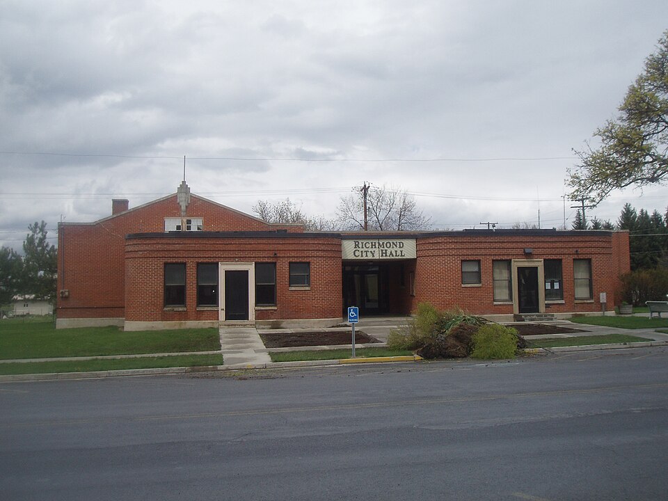
Listed on the National Register of Historic Places in 1986.
One of 80 National Register listings published here for Cache County · listed in 1986 · category: Building.
Sources: the case file at the National Archives · the National Register database, National Park Service
Regional context, not property-specific evidence. The federal wildfire occurrence database lists 44 fires within 5 miles of Richmond Community Building between 1992 and 2020, burning about 317 acres in total. 7 started naturally. 2 were recorded as arson. Distance is straight-line from the map coordinates, so a fire counted here may appear on a neighbouring settlement's page as well.
| Reported cause | Fires |
|---|---|
| Missing data/not specified/undetermined | 12 |
| Equipment and vehicle use | 9 |
| Natural | 7 |
| Debris and open burning | 5 |
| Recreation and ceremony | 4 |
| Power generation/transmission/distribution | 2 |
| Arson/incendiarism | 2 |
| Misuse of fire by a minor | 2 |
| Fireworks | 1 |
The most recent of them, most recent first, with the day each was reported and the service that recorded it.
| Date | Cause | Size | Reported by | Name on the report |
|---|---|---|---|---|
| 7 September 2008 | Misuse of fire by a minor | under an acre | Utah Division Forestry Fire State Lands | 200 WEST |
| 6 September 1996 | Missing data/not specified/undetermined | 4.0 acres | Utah Division Forestry Fire State Lands | GARR C. |
| 3 September 2005 | Natural | 23 acres | Uinta-Wasatch-Cache National Forest | NORTH FORK WFU |
| 14 September 1999 | Power generation/transmission/distribution | 30 acres | Utah Division Forestry Fire State Lands | CHERRY CREEK 1 |
| 13 September 2014 | Debris and open burning | 1.0 acres | Utah Division Forestry Fire State Lands | RICHMOND |
| 13 September 1999 | Missing data/not specified/undetermined | under an acre | Utah Division Forestry Fire State Lands | MAYOR FIRE |
| 1 September 2005 | Natural | 1.0 acres | Uinta-Wasatch-Cache National Forest | CHERRY PEAK |
| 7 August 2013 | Missing data/not specified/undetermined | 3.6 acres | Utah Division Forestry Fire State Lands | MENDANHALL |
Regional context, not property-specific evidence. The federal mineral resources record lists 21 workings within 5 miles of Richmond Community Building: 11 past producers, 7 producers, 3 occurrences. 7 still produce. What was taken out: Sand and Gravel, Construction, Lead, Copper, Iron. Distance is straight-line from the map coordinates, so a quarry counted here may appear on a neighbouring settlement's page as well.
| Where | Site | Commodity | Status | Recorded |
|---|---|---|---|---|
| Egan Claim | Lead, Iron, Barium-Barite | Occurrence | Barite, Galena, Pyrite, Siderite | |
| Egan Claim | Lead, Iron, Barium-Barite | Past Producer | ||
| Left Fork City Creek | Lead, Iron | Past Producer | ||
| Left Fork City Creek Prospect | Lead, Iron | Occurrence | Galena, Pyrite, Siderite | |
| Smithfield Canyon Claim | Copper | Occurrence | Malachite | |
| Smithfield Canyon Claim | Copper | Past Producer | ||
| Cherty Creek Pit | Sand and Gravel, Construction | Past Producer | Surface | |
| Cherty Creek Pit | Sand and Gravel, Construction | Past Producer | ||
| High Creek Pit No 1 | Sand and Gravel, Construction | Past Producer | ||
| High Creek Pit No. 1 | Sand and Gravel, Construction | Past Producer | Surface |
Regional context, not property-specific evidence. The National Weather Service names Richmond, the town this property stands in, in 7 storm reports between 2007 and 2026: 5 thunderstorm wind, 1 flood, 1 tornado. No death or injury is recorded in these reports. Each account below is quoted exactly as the forecast office filed it, from the NOAA Storm Events Database, and each date opens the federal record of that event.
| When | Event | Place named | Harm | What the report says |
|---|---|---|---|---|
| July 2011 | Thunderstorm Wind | Richmond | $55,000 | A large barn was knocked down in Richmond and several trees were reported down across the area. |
| August 2010 | Thunderstorm Wind | Richmond | $35,000 | Strong thunderstorm winds caused damage in Richmond, snapping trees and telephone poles. |
| June 2017 | Flood | Richmond | $10,000 | The Logan River exceeded flood stage several times through the first two weeks of June, with the gauge near Logan peaking at 1450 cfs on the morning of June 6. The flooding resulted in the closure of multiple campgrounds and other recreation areas in Logan Canyon, but otherwise mitigation and sandbagging helped prevent further damages. |
| April 2026 | Tornado (EF1) | Richmond | - | The tornado is estimated to have touched down at 2:25PM MT approximately 1 mile south of the Sink Rd./HWY 89 intersection in far northwestern Rich county. The tornado promptly produced EF-1 damage snapping a few softwood trees. The tornado continued tracking north along the terrain into Cache county, increasing in width and producing a notably wider swath of softwood tree damage consistent with an EF-1 rating. The tornado then took a slight turn to the northeast and slightly weakened, producing a few more instances of EF-1 damage to softwood trees before dissipating in far southern Cache county at around 2:27PM. The maximum width of this tornado was 100 yards with a path length of 0.44 miles. Special thanks to the Cache and Rich county emergency managers for the assistance getting to the damage location, and another special thanks to our local spotters for reporting the damage. |
| August 2024 | Thunderstorm Wind | Richmond | - | A wind gust of 63 mph was recorded at the Peter Sinks Rim mesonet site. |
| June 2019 | Thunderstorm Wind | Richmond | - | The Peter Sinks sensor recorded a peak gust of 60 mph. |
| August 2007 | Thunderstorm Wind | Richmond | - | A large tree was uprooted by strong winds. |
No historic map-sheet match is published for this property yet. That does not mean no map exists. This record needs a coordinate-quality review before it can be joined to a sheet boundary. Browse the county's mapped places while that work is pending.
Other National Register properties close enough to walk or drive between, ordered by distance from this one. Both positions come from the same geocoding pass that matched these properties to their map sheets.
| Photograph | Property | Distance | Listed |
|---|---|---|---|
 | Richmond Carnegie Library | under 500 feet | 1984 |
 | Hendricks Confectionery Building | under 500 feet | 2004 |
 | Richmond Tithing Office | under 500 feet | 1985 |
| Richmond City Grandstand & Baseball Field | 0.1 miles | 2005 | |
 | William S. and Margaret R. Hendricks House | 0.1 miles | 2004 |
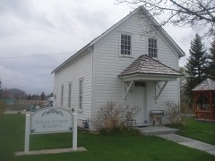 | Richmond Relief Society Hall | 0.2 miles | 1996 |
| National Archives record | The nomination case file for reference 86000731 in Record Group 79. |
| Cache County | All 80 listed properties in this county. |