 Block
From the record
6 National Register listings published here.
Sources: the National Register database, National Park Service
35 topographic sheets cover 18 settlements here, and 6 properties are on the National Register of Historic Places.
6 National Register listings published here.
Sources: the National Register database, National Park Service
Every property in this county listed on the National Register of Historic Places, with the year it was listed and the federal nomination document.
| Photograph | Property | Type | Listed | Reference |
|---|---|---|---|---|
| Columbia River Gillnet Boat | structure | 1978 | 78002783 | |
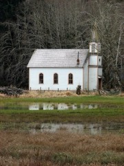 | Deep River Pioneer Lutheran Church | building | 1974 | 74001983 |
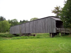 | Grays River Covered Bridge | structure | 1971 | 71000880 |
| Julia Butler Hansen House | building | 2024 | 100010342 | |
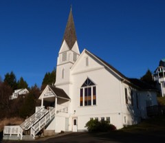 | Pioneer Church | building | 1973 | 73001893 |
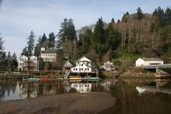 | Skamokawa Historic District | district | 1976 | 76001923 |
Wahkiakum County has 1 covered bridge on the National Register. Each is a listed structure with a federal nomination on file.
| Grays River Covered Bridge | Listed 1971 |
Every wildfire the federal occurrence database records inside this county: 58 of them, burning about 144 acres. 2 started naturally and 9 were recorded as arson. Each settlement page carries the fires within five miles of it.
| Reported cause | Fires |
|---|---|
| Debris and open burning | 16 |
| Missing data/not specified/undetermined | 13 |
| Arson/incendiarism | 9 |
| Recreation and ceremony | 7 |
| Equipment and vehicle use | 4 |
| Other causes | 3 |
| Misuse of fire by a minor | 2 |
| Natural | 2 |
| Power generation/transmission/distribution | 1 |
| Fireworks | 1 |
The five largest, by the area the report gives. None of them was recorded as arson.
| Date | Cause | Size | Reported by | Name on the report |
|---|---|---|---|---|
| 19 March 2019 | Debris and open burning | 85 acres | Washington State Department of Natural Resources Headquarters | WILDWOOD LANE |
| 24 November 2005 | Debris and open burning | 30 acres | Washington State Department of Natural Resources Headquarters | 500 |
| 6 August 2014 | Power generation/transmission/distribution | 5.0 acres | Washington State Department of Natural Resources Headquarters | EAST VALLEY |
| 30 June 2009 | Debris and open burning | 3.0 acres | Washington State Department of Natural Resources Headquarters | NAGASAWA PASS |
| 19 March 2019 | Missing data/not specified/undetermined | 3.0 acres | Washington State Department of Natural Resources Headquarters | ELOCHOMAN DIVIDE |
| 6 March 2001 | Equipment and vehicle use | 2.0 acres | Washington State Department of Natural Resources Headquarters | not named |
| 12 June 2002 | Debris and open burning | 1.7 acres | Washington State Department of Natural Resources Headquarters | not named |
| 12 April 2020 | Equipment and vehicle use | 1.5 acres | Washington State Department of Natural Resources Headquarters | DUCK CREEK |
Every settlement page carries the fires within five miles of it - see the settlement index below.
The NOAA Storm Events Database holds 47 reports for this county, causing no deaths, no injuries and about $769,000 in recorded property damage. Each settlement page carries the reports that name it.
| Kind of event | Reports |
|---|---|
| Flood | 41 |
| Heavy Rain | 5 |
| Hail | 1 |
The most serious of them, by death, then injury, then recorded damage. The accounts are quoted exactly as the forecast office filed them.
| When | Event | Place named | Harm | What the report says |
|---|---|---|---|---|
| December 2007 | Flood | Rosburg | $420,000 | The Grays River at Rosburg reached major flood levels, and one family was evacuated when flood waters inundated their home. County roads throughout the area received damage, and one family near the river lost an entire herd of cows. NOTE: Damage estimates are for the entire Wahkiakum county. |
| December 2015 | Flood | Rosburg | $339,000 | Heavy rain resulted in flooding of the Grays River near Rosburg. |
| November 2015 | Flood | Pillar Rock | $10,000 | Several roads were closed due to water on the roadways including Covered Bridge Road, Eden Valley Road, Satterland Road, Foster Road, and West End Loop Road. Grays River near Rosburg exceeded flood stage early in the morning on the 17th then exceeded major flood stage in the evening. The river crested at 16.09 feet, and fell below flood stage around 2 pm Wednesday afternoon. Heavy rain also resulted in a small landslide near milepost 2 on Altoona Pillar Rock Road. |
| February 2025 | Flood | Grays River | - | Grays River at Covered Bridge near Rosburg. Reached minor flood stage (28.5 ft) 2/25 at 3 15 am. Reached Moderate Flood (30.5 ft) 2/25 at 645 am. Peaked at 31.9 feet 2/25 at 1215pm. Fell below Moderate 2/25 at 2030 PST. Fell below minor at 2/26 5 am. |
| December 2024 | Flood | Rosburg | - | Along the Grays river an Emergency manager reported numerous road closures due to high water including Covered Bridge Road, Loop Road, and Altoona-Pillar Rock Road as of the morning of 12-18-2024. |
| December 2024 | Flood | Rosburg | - | River reached minor flood level 28.5 ft 12/26 at 830 am PST, peaked at 28.84 12/26 1145am, and fell below minor flood 12/26 5 pm. |
| December 2023 | Flood | Eden | - | The Grays River rose above flood stage on December 4th, cresting at 16.24 feet on December 5th at 9 am, and fell below flood stage on December 6th. Flood stage is 12.0 feet. |
| January 2022 | Flood | Grays River | - | The gauge on the Grays River near Rosburg rose above flood stage of 12.0 feet at 2345PST, crested at 15.5 feet on the 12th at 0715PST, the fell below flood stage at 2330PST. A mudslide closed SR-4 in both direction near Raistakka Road. |
| January 2022 | Flood | Grays River | - | The gauge on the Grays River near Rosburg rose above flood stage of 12.0 feet at 0640PST, crested at 16.2 feet on the 7th at 0200PST, then dropped below flood stage on the 8th at 0340PST. In addition to river flooding, widespread areal flooding resulted in a lot of road closures in the county, trapping people for 3 days. |
| February 2022 | Flood | Grays River | - | Minor flooding occurred along the Grays River. Heavy rain fell as surrounding areas measured 2 to 10 inches of rain. No damages were reported. |
| January 2021 | Flood | Rosburg | - | The Grays River near Rosburg rose above 1145PST on the 12th, crested at 15.54 feet, then fell below flood stage at 0215PST on the 14th. Flood stage is 12.0 feet. |
| November 2021 | Flood | Grays River | - | The Grays River crested at 12.5 feet on the afternoon of November 5th. Flood stage is 12 feet. |
| December 2020 | Flood | Grays River | - | The Grays River gage (GRRW1) measured a crest of 12.1 feet. The flood stage is 12.0 feet. No damage was reported. |
| April 2018 | Flood | Grays River | - | The Grays River near Rosburg crested at 12.6 feet around 1 AM, which is 0.6 foot above flood stage. No damage was reported. |
| December 2018 | Flood | Grays River | - | The Grays River near Rosburg crested at 13.2 feet around 11:30 AM, which is 1.2 feet above flood stage. No damage was reported. |
| February 2017 | Flood | Grays River | - | Heavy rain caused the Grays River near Rosburg to flood. The river crested at 15.57 feet, which is 3.57 feet above flood stage. |
| November 2017 | Flood | Grays River | - | The Grays River crested at 13.6 feet around 10 am, which is 1.6 feet above flood stage. No damage was reported. |
| November 2017 | Flood | Grays River | - | The Grays River crested at 15.3 feet around 12 am, which is 3.3 feet above flood stage. No damage was reported. |
| November 2017 | Flood | Grays River | - | The Grays River crested at 14.0 feet around 3 am, which is 2 feet above flood stage. No damage was reported. |
| December 2017 | Flood | Grays River | - | The Grays River near Rosburg crested at 13.4 feet around 7 pm, which is 1.4 feet above flood stage. No damage was reported. |
| October 2017 | Flood | Grays River | - | Heavy rain caused the Grays River near Rosburg to flood. The river crested at 15.56 feet, which is 3.56 feet above flood stage. |
| September 2017 | Hail | Rosburg | - | County official relayed a report of 1.0 inch hail from a resident in Rosburg. |
| October 2016 | Flood | Rosburg | - | The Grays River crested at 12.08 feet around 10 am, which is 0.08 feet above flood stage. No damage was reported. |
| November 2016 | Flood | Grays River | - | Heavy rain resulted in flooding of the Grays River near Rosburg. Grays River reached flood stage at 1021 AM on November 24th, and crested at 13.9 feet at 1215 AM November 25th. The river dropped below flood stage at 850 AM November 25th. |
| January 2015 | Flood | Rosburg | - | Grays River near Rosburg reached flood stage of 12 feet at 1205 AM on January 5th, and crested around 15.4 feet at 815 AM. The river fell below flood stage around 1030 PM. |
| January 2015 | Heavy Rain | Rosburg | - | The Washington Department of Transportation reported Westbound State Route 4 was closed at mile post 21 due to a rock or mud slide resulting from heavy rain. The rain gauge at nearby KM Mountain measured 2 inches of rain in the 6 hour period leading up to the slide. |
| February 2015 | Flood | Rosburg | - | The Grays River reached the flood stage of 12 feet at 935 AM on February 6th. The river crested at 13.9 feet at 218 PM, and dropped below flood stage at 850 PM. |
| October 2015 | Flood | Rosburg | - | Heavy rain resulted in Flooding of the Grays River. Grays River reached flood stage at 1230 pm on October 31, and crested at 14.7 feet at 415 pm. The river dropped below flood stage at 1215 AM November 1st. The local Sheriff confirmed that water from the river flooded the nearby Covered Bridge Road. |
| December 2014 | Flood | Rosburg | - | The Grays River near Rosburg reached the flood stage of 12 feet at 715 AM PST on December 20th. The river crested at 13.6 feet at 12:15 AM PST on December 21 before falling below flood stage at 8:15 AM PST. |
| March 2014 | Flood | Rosburg | - | Heavy rain resulted in the Grays River near Rosburg to reach flood stage around 7 pm on March 8. The river crested at 15 feet around 1 am on March 9th and fell below flood stage around 6 pm. |
| March 2014 | Flood | Rosburg | - | The Grays River near Rosburg briefly flooded March 6. The river reached flood stage around 11 am March 6th before cresting at 13.2 feet at 2 pm. The river fell below flood stage around 1 am on March 7th. |
| April 2014 | Flood | Rosburg | - | The Grays River near Rosburg reached flood stage around 6 am on April 24th, 2014. The river crested at 12.1 ft around 730 AM and fell below flood stage around 9 AM. |
| February 2014 | Flood | Rosburg | - | The Grays river at Rosburg reached flood stage at 150 AM PST. The river level crested at 13.2 feet at 545 AM PST, and fell below flood stage at 100 PM PST. |
| September 2013 | Flood | Rosburg | - | Around 4 inches of rain fell over the Willapa Hills, and resulted in the Grays River near Rosburg to exceed flood stage. |
| January 2012 | Flood | Grays River | - | Heavy rain combined with snowmelt runoff caused the Grays River near Rosburg to overflow its banks and flood low lying areas. The Grays River crested at 13.1 feet on January 21st at 6 am PST, 1.1 feet above flood stage. |
| February 2012 | Flood | Grays River | - | Heavy rainfall caused the Grays River near Rosburg to overflow its banks and flood low lying areas. The Grays River crested at 12.7 feet on February 22nd at 8 am PST, 0.7 feet above flood stage. |
| March 2012 | Flood | Grays River | - | Heavy rain caused the Grays River near Rosburg to overflow its banks and flood low lying areas. The Grays River crested at 12.9 feet on March 29th at 8 pm PDT, 0.9 feet above flood stage. |
| November 2012 | Flood | Grays River | - | Heavy rain caused the Grays River near Rosburg to overflow its banks and flood low lying areas. The Grays River crested at 16.0 feet on Novemeber 19th at 3 pm PST, 4.0 feet above flood stage. |
| March 2012 | Flood | Grays River | - | Heavy rain combined with snowmelt runoff causing the Grays River near Rosburg to overflow its banks and flood low lying areas. The Grays River crested at 14.7 feet on March 15th at 2 pm PDT, 2.7 feet above flood stage. |
| January 2011 | Flood | Rosburg | - | Heavy rainfall combined with snowmelt runoff to produce flooding on the Grays River. The Grays River near Rosburg crested at 14.3 feet on January 16th at 13:15 PST. |
| December 2010 | Flood | Rosburg | - | Heavy rainfall over the area caused the Grays River near Rosburg to overflow its banks. |
| January 2009 | Flood | Rosburg | - | Heavy rain combined with snowmelt runoff caused the Grays River near Rosburg to overflow its banks. |
| January 2009 | Heavy Rain | Deep River | - | Heavy rain caused flooding across highway 4, resulting in the closure of highway 4 west of Rosburg. |
| November 2008 | Flood | Rosburg | - | Heavy rains over the Willapa Hills drained into the Grays River, raising the river out of it's banks. This combined with high tides brought flooding to areas in Wahkiakum county, especially around the town of Rosburg. Flooding in the area closed local roads as well as some evacuations of people from their homes. |
| August 2001 | Heavy Rain | Countywide | - | An unseasonably wet weather system brought heavy rain to Southwestern Washington. Storm totals include 1 to 4 inches in the Coast Range and along the Coast, 1 to 3 inches in the Cascades, and 0.75 to 1.75 inches in the inland valleys. No damage reports were received. |
| January 2003 | Heavy Rain | Countywide | - | no account filed |
| March 2003 | Heavy Rain | Countywide | - | no account filed |
The Survey's mineral resources record lists 18 workings inside this county. None of them still produces: all are closed or unrecorded. Each settlement page carries the workings within five miles of it.
| Commodity | Workings |
|---|---|
| Sand and Gravel, Construction | 8 |
| Stone, Crushed/Broken | 8 |
| Stone | 2 |
The least common of them first, because a county's hundredth gravel pit says nothing its first ten did not.
| Where | Site | Commodity | Status | Recorded |
|---|---|---|---|---|
| Adams Quarry | Stone | Past Producer | ||
| Rock Creek Quarry | Stone | Past Producer | ||
| 7000 Pit # 1 | Stone, Crushed/Broken | Past Producer | ||
| Callahan Quarry | Stone, Crushed/Broken | Past Producer | ||
| Cathlamet Pit | Sand and Gravel, Construction | Past Producer | ||
| Crown Cathlamet Quarry | Stone, Crushed/Broken | Past Producer | ||
| Elokomin River Pit | Sand and Gravel, Construction | Past Producer | ||
| Elokomin River Pit | Sand and Gravel, Construction | Past Producer | ||
| Elokomin River Pit | Sand and Gravel, Construction | Past Producer | ||
| Grays River Pit | Sand and Gravel, Construction | Past Producer | ||
| Johnson Quarry | Stone, Crushed/Broken | Past Producer | ||
| Mcnally Quarry | Stone, Crushed/Broken | Past Producer | ||
| Olsen Pit | Sand and Gravel, Construction | Past Producer | ||
| Sand Pit | Sand and Gravel, Construction | Past Producer | ||
| Unnamed Pit | Sand and Gravel, Construction | Past Producer | ||
| Unnamed Quarry | Stone, Crushed/Broken | Past Producer | ||
| Unnamed Quarry | Stone, Crushed/Broken | Past Producer | ||
| Unnamed Quarry | Stone, Crushed/Broken | Past Producer |
Named settlements recorded in the Geographic Names Information System, each with the topographic sheets covering it. Villages, hamlets and abandoned places alike. Each is shown with the nearest named watercourse or landform and the survey quadrangle it falls on.
Grays River census division · 98643 · By Pigeon Bluff · Rosburg quadrangle
16 sheets, 1940 to 1981
Grays River census division · 98643 · On Harlows Creek · Grays River quadrangle
14 sheets, 1940 to 1985
No longer a settlement
Grays River census division · 98643 · Near Altoona Hill · Rosburg quadrangle
16 sheets, 1940 to 1981
Cathlamet census division · 98612 · On Birnie Creek · Cathlamet quadrangle
15 sheets, 1941 to 1985
Grays River census division · 98643 · Near Altoona Hill · Grays River quadrangle
14 sheets, 1940 to 1985
Grays River census division · 98638 · Near Wilcox Canyon · Rosburg quadrangle
16 sheets, 1940 to 1981
Cathlamet census division · 98612 · Near Little Island · Nassa Point quadrangle
15 sheets, 1941 to 1985
Grays River census division · 98643 · On South Creek · Rosburg quadrangle
16 sheets, 1940 to 1981
Grays River census division · 98621 · On Hull Creek · Grays River quadrangle
14 sheets, 1940 to 1985
Grays River census division · 98643 · On Seal Slough · Rosburg quadrangle
16 sheets, 1940 to 1981
Grays River census division · 98643 · On Nikka Creek · Rosburg quadrangle
16 sheets, 1940 to 1981
Grays River census division · 98647 · On Brooks Slough · Skamokawa quadrangle
14 sheets, 1941 to 1985
Skamokawa census division · 98647 · On Brooks Slough · Skamokawa quadrangle
14 sheets, 1941 to 1985
Skamokawa census division · 98612 · On Duck Creek · Skamokawa Pass quadrangle
15 sheets, 1941 to 1985
Grays River census division · 98638 · On Deep River · Rosburg quadrangle
16 sheets, 1940 to 1981
Cathlamet census division · 98612 · Near Cooper Island · Nassa Point quadrangle
15 sheets, 1941 to 1985
The vanished settlements of Wahkiakum County: the places named above that are no longer on the map.