 Block
From the record
One of 46 National Register listings published here for Chelan County · listed in 1982 · category: Structure · built in 1909.
Sources: the case file at the National Archives · the National Register database, National Park Service
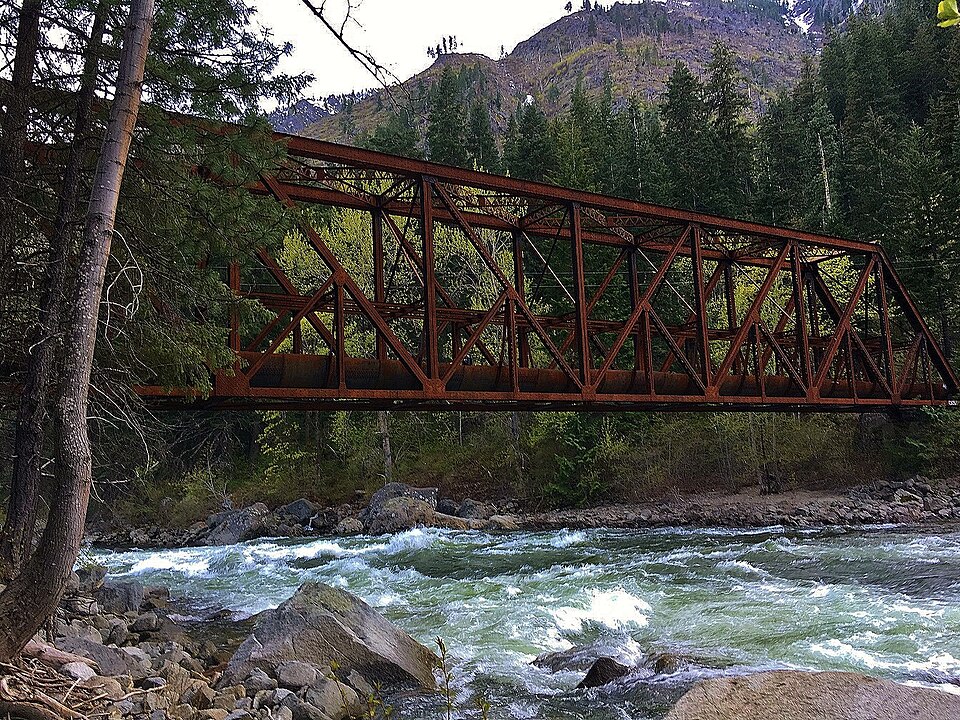
Built in 1909. Listed on the National Register of Historic Places in 1982.
One of 46 National Register listings published here for Chelan County · listed in 1982 · category: Structure · built in 1909.
Sources: the case file at the National Archives · the National Register database, National Park Service
Regional context, not property-specific evidence. The federal wildfire occurrence database lists 90 fires within 5 miles of Penstock Bridge between 1992 and 2020, burning about 37,050 acres in total. 33 started naturally. 4 were recorded as arson. Distance is straight-line from the map coordinates, so a fire counted here may appear on a neighbouring settlement's page as well.
| Reported cause | Fires |
|---|---|
| Natural | 33 |
| Recreation and ceremony | 23 |
| Missing data/not specified/undetermined | 12 |
| Debris and open burning | 10 |
| Arson/incendiarism | 4 |
| Smoking | 2 |
| Misuse of fire by a minor | 2 |
| Equipment and vehicle use | 2 |
| Power generation/transmission/distribution | 1 |
| Railroad operations and maintenance | 1 |
The most recent of them, most recent first, with the day each was reported and the service that recorded it.
| Date | Cause | Size | Reported by | Name on the report |
|---|---|---|---|---|
| 9 September 2012 | Natural | under an acre | Okanogan-Wenatchee National Forest | JOHNNY CREEK |
| 7 September 2020 | Debris and open burning | under an acre | Washington State Department of Natural Resources Headquarters | BOUNDARY BUTTE |
| 7 September 1993 | Missing data/not specified/undetermined | 5.0 acres | Okanogan-Wenatchee National Forest | not named |
| 4 September 1995 | Natural | under an acre | Okanogan-Wenatchee National Forest | ICICLE RIDGE A |
| 4 September 1995 | Natural | under an acre | Okanogan-Wenatchee National Forest | not named |
| 4 September 1995 | Natural | under an acre | Okanogan-Wenatchee National Forest | TUMWATER |
| 13 September 2014 | Recreation and ceremony | 25 acres | Okanogan-Wenatchee National Forest | TUMWATER |
| 9 August 1993 | Missing data/not specified/undetermined | under an acre | Okanogan-Wenatchee National Forest | not named |
Regional context, not property-specific evidence. The federal mineral resources record lists 16 workings within 5 miles of Penstock Bridge: 6 past producers, 4 occurrences, 3 prospects, 3 unknowns. None of them still produces. What was taken out: Sand and Gravel, Construction, Gold, Silica, Asbestos. Distance is straight-line from the map coordinates, so a quarry counted here may appear on a neighbouring settlement's page as well.
| Where | Site | Commodity | Status | Recorded |
|---|---|---|---|---|
| Black Republican | Niobium (Columbium), Cobalt, Nickel | Unknown | ||
| Bubbly Ranch | Gold, Garnet | Unknown | ||
| Leavenworth | Clay | Past Producer | ||
| Leavenworth Placer | Platinum | Occurrence | Stream Placer | |
| Redmon Pit | Stone, Crushed/Broken | Past Producer | ||
| Tumwater Canyon | Mica, Talc-Soapstone | Occurrence | ||
| Iclce Creek | Asbestos | Prospect | ||
| Leavenworth | Silica | Prospect | ||
| Leavenworth | Sand and Gravel, Construction, Silica | Prospect | ||
| Mill Creek | Asbestos | Occurrence |
Regional context, not property-specific evidence. The National Weather Service names Leavenworth, the town this property stands in, in 9 storm reports between 2006 and 2021: 4 flood, 2 flash flood, 2 debris flow, 1 heavy rain. No death or injury is recorded in these reports. Each account below is quoted exactly as the forecast office filed it, from the NOAA Storm Events Database, and each date opens the federal record of that event.
| When | Event | Place named | Harm | What the report says |
|---|---|---|---|---|
| September 2013 | Flash Flood | Leavenworth | $40,000 | Flash flooding and debris on Fourth of July Creek above Icicle Creek closed off National Park Road 76. Many campers were stranded above where the flash flood occurred until the road was cleared of debris. Damage costs were estimated. |
| January 2021 | Debris Flow | Leavenworth | $20,000 | A hillside along State Route 2 began slowly sliding, striking the Department of Transportation guardrail, and partially blocked the eastbound lane. The mudslide was triggered by already saturated soil and wet snow. |
| March 2011 | Flood | Leavenworth | $10,000 | A blocked railroad culvert resulted in water flooding out onto Chumstick Highway near Freund Canyon about 1.3 miles north of Leavenworth. The water was about a foot deep across the road for a brief period resulting in its closure. Parts of the road were damaged by the flowing water. |
| January 2015 | Flood | Leavenworth | - | Newspaper posted two photos and narrative on their Facebook page showing a structure used to store rafting equipment being flooded. Comments to the post note that the flooding is from rain, slush and melting snow and ice as the structure is in a natural depression near a mountain. |
| December 2015 | Debris Flow | Leavenworth | - | An emergency manager reported a mudslide on SR-2 just west of Leavenworth, WA. The road was closed and the flow was estimated at 10 feet deep. |
| November 2006 | Flood | Leavenworth | - | Very heavy rain led to flooding on Icicle Creek near Icicle Island. |
| November 2006 | Flood | Leavenworth | - | Very heavy rain led to rapid rises on the Wenatchee River, with major flooding of fields on East Leavenworth Road. |
| January 2009 | Heavy Rain | Leavenworth | - | no account filed |
| June 2006 | Flash Flood | Leavenworth | - | no account filed |
No historic map-sheet match is published for this property yet. That does not mean no map exists. This record needs a coordinate-quality review before it can be joined to a sheet boundary. Browse the county's mapped places while that work is pending.
Other National Register properties close enough to walk or drive between, ordered by distance from this one. Both positions come from the same geocoding pass that matched these properties to their map sheets.
| Photograph | Property | Distance | Listed |
|---|---|---|---|
 | Leavenworth Ranger Station | 2.6 miles | 1986 |
 | Leavenworth Ski Hill Historic District | 2.6 miles | 2013 |
| Leavenworth National Fish Hatchery | 4.4 miles | 1998 |
| National Archives record | The nomination case file for reference 82004196 in Record Group 79. |
| Chelan County | All 46 listed properties in this county. |