 Block
From the record
One of 20 National Register listings published here for Columbia County · listed in 1986 · category: Building.
Sources: the case file at the National Archives · the National Register database, National Park Service
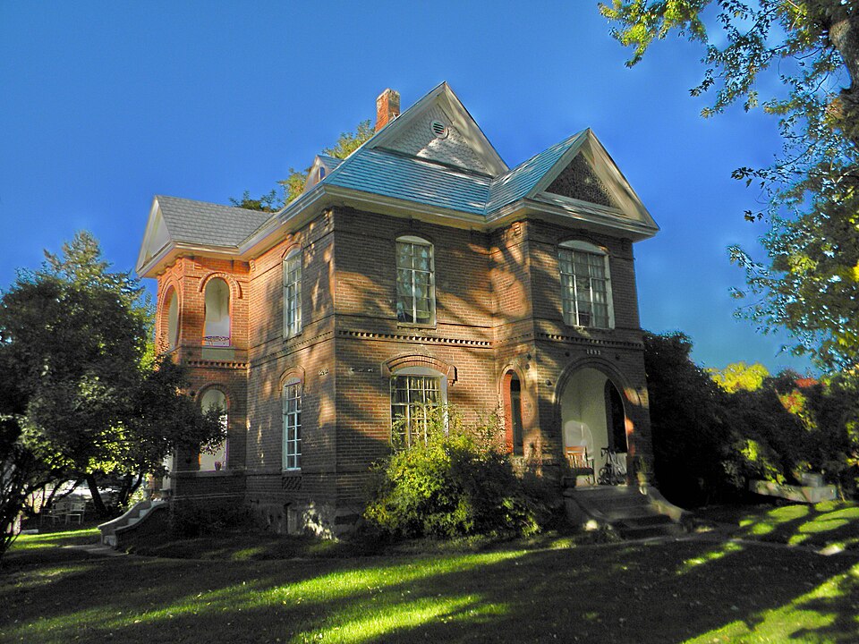
Listed on the National Register of Historic Places in 1986.
One of 20 National Register listings published here for Columbia County · listed in 1986 · category: Building.
Sources: the case file at the National Archives · the National Register database, National Park Service
Regional context, not property-specific evidence. The federal wildfire occurrence database lists 8 fires within 5 miles of J. A. Thronson House between 2006 and 2020, burning about 920 acres in total. 1 started naturally. 1 was recorded as arson. Distance is straight-line from the map coordinates, so a fire counted here may appear on a neighbouring settlement's page as well.
| Reported cause | Fires |
|---|---|
| Missing data/not specified/undetermined | 4 |
| Power generation/transmission/distribution | 1 |
| Arson/incendiarism | 1 |
| Recreation and ceremony | 1 |
| Natural | 1 |
The most recent of them, most recent first, with the day each was reported and the service that recorded it.
| Date | Cause | Size | Reported by | Name on the report |
|---|---|---|---|---|
| 25 September 2011 | Power generation/transmission/distribution | under an acre | Washington State Department of Natural Resources Headquarters | BMIDC 1010 - SOUTH TOUCHEE |
| 26 August 2020 | Missing data/not specified/undetermined | under an acre | Columbia County Fire Districts | INC 994 |
| 2 August 2006 | Missing data/not specified/undetermined | 800 acres | Washington State Department of Natural Resources Headquarters | not named |
| 18 August 2014 | Arson/incendiarism | 7.2 acres | Washington State Department of Natural Resources Headquarters | BMIDC INC 995 |
| 12 August 2014 | Natural | 100 acres | Washington State Department of Natural Resources Headquarters | BMIDC INC 914 - CORRAL HOLLOW |
| 18 July 2007 | Missing data/not specified/undetermined | under an acre | Washington State Department of Natural Resources Headquarters | not named |
| 27 May 2017 | Recreation and ceremony | 1.5 acres | Washington State Department of Natural Resources Headquarters | LEWIS AND CLARK |
| 18 April 2019 | Missing data/not specified/undetermined | 10 acres | Washington State Department of Natural Resources Headquarters | MUSTARD HOLLOW |
Regional context, not property-specific evidence. The federal mineral resources record lists 8 workings within 5 miles of J. A. Thronson House: 7 past producers, 1 producer. 1 still produces. What was taken out: Stone, Crushed/Broken, Sand and Gravel, Construction, Clay. Distance is straight-line from the map coordinates, so a quarry counted here may appear on a neighbouring settlement's page as well.
| Where | Site | Commodity | Status | Recorded |
|---|---|---|---|---|
| Dayton | Clay | Past Producer | ||
| Unnamed Pit | Sand and Gravel, Construction | Past Producer | ||
| Borrow Pit | Stone, Crushed/Broken | Past Producer | ||
| Gaines Quarry | Stone, Crushed/Broken | Producer | ||
| Patit Creek Quarry | Stone, Crushed/Broken | Past Producer | ||
| Unnamed Quarry | Stone, Crushed/Broken | Past Producer | ||
| Unnamed Quarry | Stone, Crushed/Broken | Past Producer | ||
| Unnamed Quarryy | Stone, Crushed/Broken | Past Producer |
Regional context, not property-specific evidence. The National Weather Service names Dayton, the town this property stands in, in 13 storm reports between 1998 and 2026: 6 thunderstorm wind, 2 flood, 1 heavy rain, 1 tornado. No death or injury is recorded in these reports. Each account below is quoted exactly as the forecast office filed it, from the NOAA Storm Events Database, and each date opens the federal record of that event.
| When | Event | Place named | Harm | What the report says |
|---|---|---|---|---|
| January 2000 | Tornado (F1) | Dayton | $100,000 | no account filed |
| July 2012 | Thunderstorm Wind | Dayton | $50,000 | Thunderstorm winds downed trees on power lines and at least one house. |
| March 2026 | Flood | Dayton | - | The Columbia County Emergency Managers office reported flooding of residences and water over roadways in the town of Dayton the morning of the 14th. Drone footage over Dayton taken on the 14th showed the Touchet river overflowing it's banks into numerous properties adjacent to the river, with flooding also along the Patit Creek that runs through the northern portion of Dayton. |
| February 2020 | Flood | Dayton | - | The North Fork and main Fork of the Touchet River as well as Coppei Creek and the Tuccanon River saw major flooding with numerous roads, bridges and home affected. 19 roads were closed, 21 bridges have moderate to severe damage, 144 homes were damaged and over 500 minor structures ( culverts, smaller bridges) affected. No dollar estimate at this time. |
| May 2020 | Thunderstorm Wind | Dayton | - | Trees and powerlines down in Dayton. |
| September 2013 | Thunderstorm Wind | Dayton | - | Trees and power lines down. |
| September 2013 | Thunderstorm Wind | Dayton | - | Trees and power lines down. |
| June 2012 | Hail | Dayton | - | Hail damaged window covers on truck. |
| March 2011 | Thunderstorm Wind | Dayton | - | Dayton Middle School recorded a gust to 59 mph. |
| July 1998 | Heavy Rain | Dayton | - | Up to two inches of rain fell in 45 minutes. Flooding was reported along Patit Creek. Water washed out nearby roads and mudslides covered some roads with as much as three inches of mud. 1/2 inch hail also fell. |
| September 2013 | Flash Flood | Dayton | - | no account filed |
| August 2001 | Lightning | Dayton | - | no account filed |
| May 2000 | Thunderstorm Wind | Dayton | - | no account filed |
No historic map-sheet match is published for this property yet. That does not mean no map exists. This record needs a coordinate-quality review before it can be joined to a sheet boundary. Browse the county's mapped places while that work is pending.
Other National Register properties close enough to walk or drive between, ordered by distance from this one. Both positions come from the same geocoding pass that matched these properties to their map sheets.
| Photograph | Property | Distance | Listed |
|---|---|---|---|
 | Dexter House No. 1 | under 500 feet | 1986 |
 | Frank Flintner House | 0.2 miles | 1986 |
 | Grover J. Israel House | 0.2 miles | 1986 |
| South Side Historic District | 0.2 miles | 1986 | |
 | Dr. Marcel Pietrzycki House | 0.3 miles | 1986 |
| Downtown Dayton Historic District | 0.4 miles | 1999 |
| National Archives record | The nomination case file for reference 86001532 in Record Group 79. |
| Columbia County | All 20 listed properties in this county. |