 Block
From the record
One of 33 National Register listings published here for Skagit County · listed in 1987 · category: Structure · built in 1932.
Sources: the case file at the National Archives · the National Register database, National Park Service
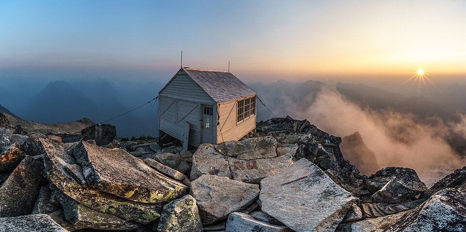
Built in 1932. Listed on the National Register of Historic Places in 1987.
One of 33 National Register listings published here for Skagit County · listed in 1987 · category: Structure · built in 1932.
Sources: the case file at the National Archives · the National Register database, National Park Service
Regional context, not property-specific evidence. The federal wildfire occurrence database lists 25 fires within 5 miles of Hidden Lake Peak Lookout between 1992 and 2018, burning about 3,672 acres in total. 22 started naturally. None was recorded as arson. Distance is straight-line from the map coordinates, so a fire counted here may appear on a neighbouring settlement's page as well.
| Reported cause | Fires |
|---|---|
| Natural | 22 |
| Recreation and ceremony | 3 |
The most recent of them, most recent first, with the day each was reported and the service that recorded it.
| Date | Cause | Size | Reported by | Name on the report |
|---|---|---|---|---|
| 6 September 1998 | Recreation and ceremony | under an acre | Mt. Baker-Snoqualmie National Forest | LA RUSH |
| 14 September 2013 | Natural | 5.0 acres | North Cascades National Park | ELODORADO |
| 1 September 2003 | Natural | 1.0 acres | Mt. Baker-Snoqualmie National Forest | SONNY JIM |
| 7 August 2003 | Natural | 1.1 acres | Mt. Baker-Snoqualmie National Forest | FOUND LAKE #1 |
| 7 August 2003 | Natural | 1.0 acres | Mt. Baker-Snoqualmie National Forest | FOUND LAKE #2 |
| 6 August 2003 | Natural | under an acre | Mt. Baker-Snoqualmie National Forest | RIDGE TOP #1 |
| 6 August 2003 | Natural | under an acre | Mt. Baker-Snoqualmie National Forest | RIDGE TOP #2 |
| 6 August 2003 | Natural | 1.0 acres | Mt. Baker-Snoqualmie National Forest | RIDGE TOP #3 |
Regional context, not property-specific evidence. The federal mineral resources record lists 20 workings within 5 miles of Hidden Lake Peak Lookout: 11 occurrences, 5 past producers, 2 unknowns, 2 prospects. None of them still produces. What was taken out: Gold, Lead, Talc-Soapstone, Lead, Silver. Distance is straight-line from the map coordinates, so a quarry counted here may appear on a neighbouring settlement's page as well.
| Where | Site | Commodity | Status | Recorded |
|---|---|---|---|---|
| Cascade | Lead, Silver, Gold | Past Producer | ||
| Cascade Claims | Silver, Lead, Gold | Occurrence | Gold, Pyrite | |
| Cutthroat | Cobalt | Occurrence | ||
| Eldorado | Lead, Silver, Gold, Zinc | Occurrence | Gold, Sphalerite | |
| Johnsburg | Zinc, Silver, Copper, Gold, Lead | Occurrence | ||
| Johnsburg | Copper, Zinc, Silver, Lead, Gold | Past Producer | 1892 | |
| Johnsburg Claims | Lead, Silver, Gold, Zinc, Copper | Past Producer | Anglesite, Chalcopyrite, Galena, Malachite, Sphalerite | |
| Marble Creek | Limestone, Dimension | Occurrence | ||
| Mineral Park | Quartz | Occurrence | ||
| Mount Eldorado | Mercury | Occurrence | Unknown |
Regional context, not property-specific evidence. The National Weather Service names Marblemount, the town this property stands in, in 5 storm reports between 2009 and 2024: 4 flash flood, 1 flood. The reports record 2 injuries. Each account below is quoted exactly as the forecast office filed it, from the NOAA Storm Events Database, and each date opens the federal record of that event.
| When | Event | Place named | Harm | What the report says |
|---|---|---|---|---|
| July 2009 | Flash Flood | Marblemount | 2 hurt, $4,000 | Heavy rainfall from a thunderstorm caused a flash flood and debris flow that covered State Route 20. The debris flow was 300 yards wide and more than 10 feet deep. Two people were treated for minor injuries from the debris flow and their motorcycle had to be towed back to Marblemount. |
| November 2021 | Flood | Marblemount | $12,000,000 | Heavy rain and some snow melt caused flooding throughout much of Skagit County, especially on the Skagit and Samish Rivers. Flooding on the Skagit started on the 12th, then temporarily dropped below flood stage, before rising to major flood on the night of the 14th. 2 fatalities occurred during this time with many road, highways, and bridges closed due to water over roadway, washouts, sloughing, and debris. Town inundated including Rockport, Hamilton, Lyman, Sedro Woolley, and Mount Vernon. There was urban and small stream flooding as well on the 15th.The heavy rain also triggered a number of landslides throughout the area. Damages are reported and estimated; not all damages have been identified. Crop damages are unknown. |
| August 2024 | Flash Flood | Marblemount | $103,400 | Heavy rain from a couple of thunderstorms fell over the mountain ridge, above the recent Easy Fire burn scar, with the main period of heavy rain lasting about one hour and 45 minutes starting 1800PST. Flash floods and debris flows came out of several drainages along and northeast of State Route 20 between mile post 151 and 152.5, burying the highway. The debris flows initiated above the burn scar and little of the flood debris was from the burn scar itself. It took two weeks to clean up and fix the highway to make it passable. |Rain rates from a nearby rain gage along the highway were up to 0.29 inches in 15 minutes, 0.53 inches in 30 minutes, 0.96 inches in 1 hour, and a two hour storm total of 1.28 inches. No injuries or fatalities occurred. |
| August 2013 | Flash Flood | Marblemount | $100,000 | Flash floods left mud and debris across Highway 20 northwest of Rainy Pass. The road was closed for nearly a week and suffered some damage. Cascade River Road was also damaged. |
| September 2013 | Flash Flood | Marblemount | $100,000 | Rain caused flash floods and mudslides in several locations and closed a 24-mile section of the North Cascades Highway. |
No historic map-sheet match is published for this property yet. That does not mean no map exists. This record needs a coordinate-quality review before it can be joined to a sheet boundary. Browse the county's mapped places while that work is pending.
Other National Register properties close enough to walk or drive between, ordered by distance from this one. Both positions come from the same geocoding pass that matched these properties to their map sheets.
| Photograph | Property | Distance | Listed |
|---|---|---|---|
 | Gilbert's Cabin | 5.3 miles | 1989 |
| National Archives record | The nomination case file for reference 87001184 in Record Group 79. |
| Skagit County | All 33 listed properties in this county. |