 Block
From the record
One of 159 National Register listings published here for Spokane County · listed in 1992 · category: Building · built in 1900.
Sources: the case file at the National Archives · the National Register database, National Park Service
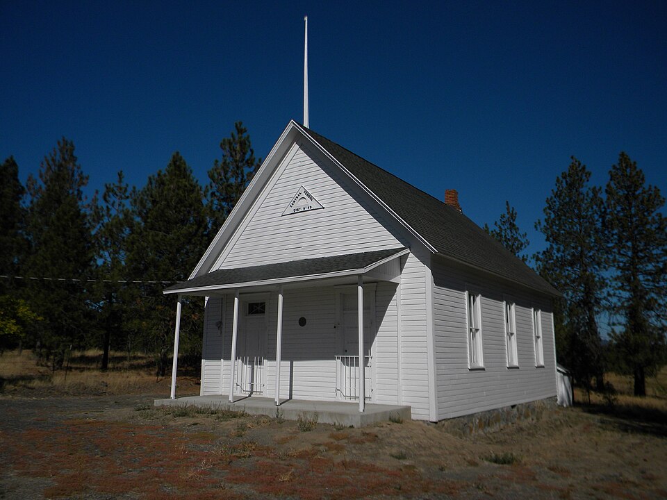
Built in 1900. Listed on the National Register of Historic Places in 1992.
One of 159 National Register listings published here for Spokane County · listed in 1992 · category: Building · built in 1900.
Sources: the case file at the National Archives · the National Register database, National Park Service
Regional context, not property-specific evidence. The federal wildfire occurrence database lists 215 fires within 5 miles of Central Schoolhouse (District No. 49) between 1992 and 2020, burning about 2,568 acres in total. 28 started naturally. 7 were recorded as arson. Distance is straight-line from the map coordinates, so a fire counted here may appear on a neighbouring settlement's page as well.
| Reported cause | Fires |
|---|---|
| Debris and open burning | 51 |
| Missing data/not specified/undetermined | 42 |
| Recreation and ceremony | 41 |
| Natural | 28 |
| Fireworks | 13 |
| Other causes | 9 |
| Smoking | 9 |
| Arson/incendiarism | 7 |
| Misuse of fire by a minor | 7 |
| Equipment and vehicle use | 6 |
| Power generation/transmission/distribution | 2 |
The most recent of them, most recent first, with the day each was reported and the service that recorded it.
| Date | Cause | Size | Reported by | Name on the report |
|---|---|---|---|---|
| 8 September 2018 | Missing data/not specified/undetermined | under an acre | Washington State Department of Natural Resources Headquarters | DEVILS GAP |
| 7 September 2014 | Missing data/not specified/undetermined | under an acre | Washington State Department of Natural Resources Headquarters | LUPIN LANE |
| 7 September 2006 | Misuse of fire by a minor | under an acre | Washington State Department of Natural Resources Headquarters | not named |
| 7 September 1992 | Missing data/not specified/undetermined | under an acre | Washington State Department of Natural Resources Headquarters | not named |
| 5 September 2013 | Natural | 1.2 acres | Washington State Department of Natural Resources Headquarters | CALHOON |
| 5 September 2000 | Recreation and ceremony | under an acre | Washington State Department of Natural Resources Headquarters | not named |
| 4 September 2020 | Recreation and ceremony | under an acre | Washington State Department of Natural Resources Headquarters | FISK |
| 4 September 1995 | Natural | 3.0 acres | Washington State Department of Natural Resources Headquarters | not named |
Regional context, not property-specific evidence. The federal mineral resources record lists 5 workings within 5 miles of Central Schoolhouse (District No. 49): 5 past producers. None of them still produces. What was taken out: Sand and Gravel, Construction. Distance is straight-line from the map coordinates, so a quarry counted here may appear on a neighbouring settlement's page as well.
| Where | Site | Commodity | Status | Recorded |
|---|---|---|---|---|
| Gravel Pit | Sand and Gravel, Construction | Past Producer | ||
| Lunnamed Pit | Sand and Gravel, Construction | Past Producer | ||
| Unnamed Pit | Sand and Gravel, Construction | Past Producer | ||
| Unnamed Pit | Sand and Gravel, Construction | Past Producer | ||
| Unnamed Pit | Sand and Gravel, Construction | Past Producer |
Regional context, not property-specific evidence. The National Weather Service names Nine Mile Falls, the town this property stands in, in 3 storm reports between 2016 and 2017: 1 flash flood, 1 flood, 1 thunderstorm wind. No death or injury is recorded in these reports. Each account below is quoted exactly as the forecast office filed it, from the NOAA Storm Events Database, and each date opens the federal record of that event.
| When | Event | Place named | Harm | What the report says |
|---|---|---|---|---|
| March 2017 | Flood | Nine Mile Falls | $100,000 | The Little Spokane River Gage at Dartford recorded a rise above the Flood Stage of 6.5 feet at 2:45 PM PST March 15th. The river fluctuated slightly above and below Flood Stage before rising again and cresting 6.8 feet at 11:15 AM on March 19th. The river then slowly receded, dropping below Flood Stage at 2:15 AM March 20th. |
| June 2017 | Thunderstorm Wind | Nine Mile Falls | - | A two foot diameter Ponderosa Pine tree was uprooted at Sontag Park northwest of Spokane. Several other trees were blown down or snapped in the vicinity. |
| May 2016 | Flash Flood | Nine Mile Falls | - | A member of the public reported water over roadways and entering basements of some homes in and near Nine Mile Falls, WA. |
No historic map-sheet match is published for this property yet. That does not mean no map exists. This record needs a coordinate-quality review before it can be joined to a sheet boundary. Browse the county's mapped places while that work is pending.
Other National Register properties close enough to walk or drive between, ordered by distance from this one. Both positions come from the same geocoding pass that matched these properties to their map sheets.
| Photograph | Property | Distance | Listed |
|---|---|---|---|
 | Nine Mile Hydroelectric Power Plant Historic District | 7.9 miles | 1990 |
| National Archives record | The nomination case file for reference 92001040 in Record Group 79. |
| Spokane County | All 159 listed properties in this county. |