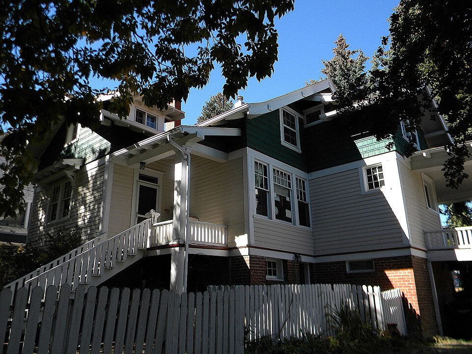
Listed on the National Register of Historic Places in 1994.
From the record
“Main St. in Pullman, Washington, is an American Craftsman style bungalow house built in 1914. It was a home of architect William Swain who was elected mayor of Pullman in the year the house was completed.”
Wikipedia article William Swain House, CC BY-SA 4.0.
One of 39 National Register listings published here for Whitman County · listed in 1994 · category: Building.
National Register reference number.94000801- the number the National Park Service assigned this property when it was listed, and the key its nomination file is catalogued under at the National Archives.
Mines and
quarries near this property
10 of 17 shown
Regional context, not property-specific
evidence. The federal mineral resources record lists
17 workings within 5 miles of William Swain House: 17 past producers.
None of them still produces. What was taken out: Stone, Crushed/Broken, Sand and Gravel, Construction, Clay. Distance is straight-line from the
map coordinates, so a quarry counted here may appear on a neighbouring
settlement's page as well.
Regional context, not property-specific
evidence. The National Weather Service names
Pullman, the town this property stands in, in 20 storm reports between 1997 and 2026: 8 thunderstorm wind, 4 flash flood, 4 flood, 2 hail.
No death or injury is recorded in these reports. Each account below is quoted exactly as the forecast office
filed it, from the NOAA Storm Events Database, and each date
opens the federal record of that event.
Missouri Flat Creek experienced a Flash Flood which resulted in the North Grand Avenue business district being inundated with up to 4 feet of water in places. Numerous businesses were damaged and parked cars were floated and carried away. Pullman police and fire crews made numerous water rescues of stranded customers and employees of at least 4 businesses including the rescue of 16 people from one business. There were no known injuries and by the next morning the creek had receded back into it's banks.
Rapid snowmelt and heavy rain lead to rising creeks and streams across Whitman County, which lead to high water levels on the North Fork of the Palouse River. Several homes and business had reports of flooding.
Rapid snowmelt and 2-4 inches of rain lead to flooding of small creeks and streams around Pullman. Portions of the WSU campus exerienced flooding, while several downtown businesses and city streets were indunated by a foot of water. Portions of Highway 195 were closed.
South Fork Palouse River flooding, with minor to moderate flooding in areas across Pullman, including downtown, Grand Avenue, and the area around the City Playfields. Water covered N Grand north of NW Windus St. NE Morton St by Reaney pool was flooded across all lanes. Grand Avenue closed from Nye to Ritchie. Main Street from Spring to Pine was closed. Morton Street near Reaney Park closed due to flooding.
Brief heavy rain from a thunderstorm pooled at an intersection in downtown Pullman apparently due to leaf clogged storm drains. The water pooled about 9 inches deep in the intersection which was sufficient to cause minor first floor flooding in a number of adjacent business establishments.
Heavy rain and rapid snow melt led to water over roadway on North Grand by Mobil Station and Cougar County Drive In.. The Pullman Airport recorded 1.15 inches of rain.
A small funnel cloud dissipated shortly after formation. There is no indication that the circulation ever made contact with the ground. The location is estimated from social media shared by the media.
Strong outflow winds from a thunderstorm contributed to several downed power lines in Pullman with about 60 customers losing power. Six trees fell on roads, three trees fell on cars, and two power lines were downed.
No historic map-sheet match is published
for this property yet. That does not mean no map exists. This record needs
a coordinate-quality review before it can be joined to a sheet boundary.
Browse the county's mapped places while that work is
pending.
Listed places nearby
6 within 8 miles
Other National Register properties close
enough to walk or drive between, ordered by distance from this one. Both
positions come from the same geocoding pass that matched these properties
to their map sheets.
Listing record. National Park Service National Register of Historic Places, listed-properties dataset, current to 2026-05-22.
Map join. Address geocoded through the United States Census geocoder, then tested against the published boundary of every sheet in the USGS Historical Topographic Map Collection.
How this page is made. Listing fields come from federal records; map-sheet coverage is a labelled coordinate-to-boundary calculation, not a source-field claim.
Mines and quarries. USGS Mineral Resources Data System (MRDS) https://mrdata.usgs.gov/mrds/ A work of the United States government, no copyright under 17 U.S.C. 105.
Storms. NOAA National Centers for Environmental Information, Storm Events Database https://www.ncei.noaa.gov/stormevents/ A work of the United States government, no copyright under 17 U.S.C. 105. Narratives are quoted verbatim from the National Weather Service report and are not edited or summarised.
 Block