 Block
From the record
5 National Register listings published here.
Sources: the National Register database, National Park Service
30 topographic sheets cover 12 settlements here, and 5 properties are on the National Register of Historic Places.
5 National Register listings published here.
Sources: the National Register database, National Park Service
Every property in this county listed on the National Register of Historic Places, with the year it was listed and the federal nomination document.
| Photograph | Property | Type | Listed | Reference |
|---|---|---|---|---|
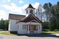 | Fern School | building | 1981 | 81000043 |
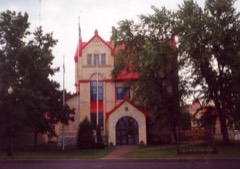 | Florence County Courthouse and Jail | building | 1985 | 85003029 |
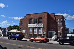 | Florence Town Hall | building | 2014 | 14000169 |
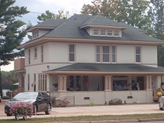 | David M. and Lottie Fulmer House | building | 2014 | 14000196 |
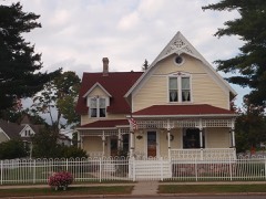 | Robert B. and Estelle J. Webb House | building | 2014 | 14000197 |
Every wildfire the federal occurrence database records inside this county: 320 of them, burning about 294 acres. 8 started naturally and 14 were recorded as arson. Each settlement page carries the fires within five miles of it.
| Reported cause | Fires |
|---|---|
| Debris and open burning | 120 |
| Missing data/not specified/undetermined | 59 |
| Equipment and vehicle use | 37 |
| Power generation/transmission/distribution | 25 |
| Recreation and ceremony | 24 |
| Arson/incendiarism | 14 |
| Smoking | 10 |
| Fireworks | 10 |
| Misuse of fire by a minor | 8 |
| Natural | 8 |
| Other causes | 5 |
The five largest, by the area the report gives. None of them was recorded as arson.
| Date | Cause | Size | Reported by | Name on the report |
|---|---|---|---|---|
| 4 April 1998 | Debris and open burning | 28 acres | Wisconsin Department of Natural Resources | not named |
| 12 March 2016 | Debris and open burning | 21 acres | Chequamegon-Nicolet National Forest | RED DEER |
| 29 April 2018 | Debris and open burning | 19 acres | Wisconsin Department of Natural Resources | ANDERSON ROAD FIRE |
| 28 April 1996 | Debris and open burning | 12 acres | Wisconsin Department of Natural Resources | not named |
| 7 April 2009 | Missing data/not specified/undetermined | 12 acres | Wisconsin Department of Natural Resources | FRIBERG FIRE |
| 6 May 2010 | Natural | 10 acres | Chequamegon-Nicolet National Forest | HALSEY SOUTH |
| 23 April 1993 | Smoking | 10 acres | Wisconsin Department of Natural Resources | not named |
| 26 April 1997 | Debris and open burning | 9.5 acres | Wisconsin Department of Natural Resources | not named |
Every settlement page carries the fires within five miles of it - see the settlement index below.
The NOAA Storm Events Database holds 82 reports for this county, causing no deaths, no injuries and about $2,083,500 in recorded property damage. Each settlement page carries the reports that name it.
| Kind of event | Reports |
|---|---|
| Thunderstorm Wind | 47 |
| Hail | 26 |
| Tornado | 5 |
| Flash Flood | 3 |
| Lightning | 1 |
The most serious of them, by death, then injury, then recorded damage. The accounts are quoted exactly as the forecast office filed them.
| When | Event | Place named | Harm | What the report says |
|---|---|---|---|---|
| July 1999 | Flash Flood | Florence | $1,580,000 | no account filed |
| July 2013 | Lightning | Hematite | $162,000 | Lightning stuck a gas line, causing a fire that destroyed the adjacent house. |
| April 2004 | Thunderstorm Wind | Florence | $120,000 | no account filed |
| July 1999 | Thunderstorm Wind | Long Lake | $102,000 | no account filed |
| September 2002 | Tornado (F1) | Spread Eagle | $50,000 | no account filed |
| June 1957 | Tornado (F1) | not stated | $25,000 | no account filed |
| April 2011 | Tornado (EF0) | Long Lake | $15,000 | The tornado that formed near Argonne (Forest County) entered southwest Florence County at 7:46 pm CDT (1846 CST). Several large tree branches were broken (DI 28, DOD 2) before the tornado dissipated at 7:51 pm CDT (1851 CST). The average path width of the tornado in Florence County was 75 yards. |
| August 2000 | Thunderstorm Wind | Commonwealth | $15,000 | no account filed |
| July 2002 | Thunderstorm Wind | Tipler | $5,000 | no account filed |
| August 1996 | Thunderstorm Wind | Florence | $5,000 | no account filed |
| September 2015 | Thunderstorm Wind | Pentoga | $2,000 | Thunderstorm winds downed a couple of trees on Highway 70 between Tipler and Florence. Torrential rainfall accompanied the highs winds. |
| July 1995 | Thunderstorm Wind | Florence | $1,500 | no account filed |
| July 2010 | Flash Flood | Ridgetop | $1,000 | Runoff from very heavy rainfall washed out secondary roads and culverts along Highway 70 near Florence. |
| July 2025 | Thunderstorm Wind | Spread Eagle | - | Thunderstorm winds downed trees and power lines near Aurora. The time of this report is an estimate based on radar data. |
| July 2025 | Thunderstorm Wind | Spread Eagle | - | Thunderstorm winds downed trees and power lines down in Aurora. |
| May 2024 | Hail | Ridgetop | - | Penny size hail fell near Commonwealth. The time of this report is an estimate based on radar data. |
| July 2023 | Tornado (EF0) | Long Lake | - | A brief tornado formed at 7:22 pm CDT in the Hiles area in Forest County and continued southeast before dissipating at 7:26 pm CDT. Total path length is estimated to be 1.68 miles long, with a width of 90 yards. Peak wind estimated to be around 76 mph. |
| May 2022 | Hail | Commonwealth | - | Lime size hail fell in Commonwealth. |
| June 2021 | Hail | Florence | - | Penny size hail fell in Florence. |
| July 2021 | Thunderstorm Wind | Tipler | - | Thunderstorm winds downed trees and power lines in Tipler and across Florence County. The time of this event is an estimate based on radar data. |
| August 2020 | Thunderstorm Wind | Long Lake | - | Thunderstorm winds downed trees and power poles in Long Lake. The time of this report is an estimate based on radar data. |
| August 2020 | Tornado (EF1) | Tipler | - | The tornado that formed at 9:12 PM CDT in extreme northeast Forest County crossed the county line at 9:18 PM CDT. The tornado continued east, producing a path of tree damage (DI 27,28, DOD 3,4) in a remote forested area in extreme northwest Florence County, before crossing the Brule River into Upper Michigan at 9:20 PM CDT. Peak winds were estimated at 105 mph. |
| August 2019 | Thunderstorm Wind | Fence | - | Thunderstorm winds downed a few trees in Fence. |
| August 2019 | Thunderstorm Wind | Spread Eagle | - | Thunderstorm winds downed a couple of aspen trees in Spread Eagle. |
| June 2017 | Thunderstorm Wind | Ridgetop | - | Thunderstorm winds downed trees and power lines west of Florence. |
| June 2017 | Thunderstorm Wind | Ridgetop | - | Thunderstorm winds downed trees and power lines west of Florence. |
| July 2017 | Hail | Spread Eagle | - | Nickel size hail fell north of Spread Eagle. |
| July 2017 | Thunderstorm Wind | Spread Eagle | - | Thunderstorm winds tore dead branches from trees near Spread Eagle. |
| July 2017 | Hail | Long Lake | - | Half dollar size hail fell near Long Lake and winds from the storms downed a few trees. |
| May 2016 | Thunderstorm Wind | Tipler | - | Thunderstorm winds downed trees and power lines west of Florence, starting fires at many locations. |
| July 2016 | Thunderstorm Wind | Tipler | - | Thunderstorm winds downed numerous trees and power lines in the western part of Florence County, in the Tipler, Long Lake and Fern areas. The time of this event was estimated based on radar data. |
| August 2015 | Hail | Hematite | - | Quarter size hail fell southeast of Florence. |
| September 2015 | Hail | Pentoga | - | Quarter size hail was found on the ground east of Tipler about thirty minutes after a severe thunderstorm passed through that area. |
| August 2013 | Hail | Tipler | - | The public reported 1.00 inch diameter hail at Lost Lake or approximately 4 miles East-Southeast of the town of Tipler. |
| May 2012 | Thunderstorm Wind | Fence | - | Thunderstorm winds downed trees and power lines in Fence. |
| May 2012 | Thunderstorm Wind | Ridgetop | - | Thunderstorm winds downed trees and power lines southwest of Florence. |
| July 2012 | Hail | Fence | - | Thunderstorms produced quarter size hail north of Fence. |
| September 2012 | Thunderstorm Wind | Long Lake | - | Several trees were downed by thunderstorm winds near 60 mph just east of Halsey Lake. |
| June 2011 | Hail | Florence | - | A thunderstorm produced penny size hail that covered the ground in Florence. |
| June 2011 | Hail | Ridgetop | - | A severe thunderstorm produced strong winds and golf ball size hail which whitened the ground west of Florence. |
| July 2011 | Thunderstorm Wind | Spread Eagle | - | Several trees were knocked down along County Highway B near Aurora. |
| July 2010 | Thunderstorm Wind | Florence | - | Thunderstorm winds downed trees on State Highway 70 and County Road N. |
| July 2010 | Thunderstorm Wind | Hematite | - | Thunderstorm winds downed trees near Highway N south of Florence. |
| July 2010 | Thunderstorm Wind | Tipler | - | Thunderstorms winds downed trees at the intersection of State Highways 70 and 139 near Tipler. Time of report is estimated. |
| May 2008 | Hail | Tipler | - | Large hail fell near Tipler but there was little rain or wind with it. |
| May 2008 | Hail | Spread Eagle | - | A spotter observed nickel size hail that stripped leaves and small twigs from trees. The hail was two inches deep. |
| May 2007 | Thunderstorm Wind | Tipler | - | Several trees were reported down 10 miles southeast of the town of Tipler. |
| June 2007 | Thunderstorm Wind | Tipler | - | Trees and power lines down. |
| June 2007 | Thunderstorm Wind | Fence | - | Trees and power lines down. |
| June 2007 | Thunderstorm Wind | Florence | - | Trees down at State Highway 70. |
| August 2007 | Thunderstorm Wind | Florence | - | Thunderstorm winds downed several trees near Florence. |
| May 2008 | Hail | Long Lake | - | no account filed |
| June 2007 | Hail | Spread Eagle | - | no account filed |
| June 2007 | Hail | Spread Eagle | - | no account filed |
| June 2005 | Thunderstorm Wind | Tipler | - | no account filed |
| June 2005 | Thunderstorm Wind | Tipler | - | no account filed |
| June 2005 | Thunderstorm Wind | Spread Eagle | - | no account filed |
| April 2004 | Hail | Florence | - | no account filed |
| August 2004 | Thunderstorm Wind | Tipler | - | no account filed |
| July 2003 | Hail | Long Lake | - | no account filed |
The Survey's mineral resources record lists 51 workings inside this county. 7 still produce and 44 are closed or unrecorded. Each settlement page carries the workings within five miles of it.
| Commodity | Workings |
|---|---|
| Sand and Gravel, Construction | 40 |
| Iron | 8 |
| Copper, Iron | 1 |
| Molybdenum | 1 |
| Copper | 1 |
The least common of them first, because a county's hundredth gravel pit says nothing its first ten did not.
| Where | Site | Commodity | Status | Recorded |
|---|---|---|---|---|
| Fence Prospect | Copper | Unknown | 1985 | |
| Lasalle Falls | Copper, Iron | Unknown | Argentite, Chalcocite, Pyrite | |
| Payant-Chrissman | Molybdenum | Occurrence | Molybdenite | |
| Commonwealth Group | Iron | Past Producer | 1880, 1916 | |
| Commonwealth Group | Iron | Past Producer | 1880 | |
| Ernst Mine | Iron | Past Producer | 1849, 1914, 1929 | |
| Ernst Mine | Iron | Past Producer | 1912, 1914 | |
| Florence Mine | Iron | Past Producer | 1849, 1880, 1931 | |
| Florence Mine | Iron | Past Producer | 1880 | |
| Larson Exploration | Iron | Prospect | ||
| Larson Exploration Prospect | Iron | Occurrence | 1849, 1948 | |
| Blooms Pit | Sand and Gravel, Construction | Producer | ||
| Commonwealth Gravel Deposit | Sand and Gravel, Construction | Occurrence | ||
| Commonwealth Gravel Pit | Sand and Gravel, Construction | Past Producer | ||
| Curtis Carlson Gravel Pit | Sand and Gravel, Construction | Past Producer | ||
| D. Crombie Sand Deposit | Sand and Gravel, Construction | Occurrence | ||
| Dave Roach Gravel Deposit | Sand and Gravel, Construction | Occurrence | ||
| Fisher Lake Gravel Deposit | Sand and Gravel, Construction | Occurrence | ||
| Florence County Gravel Deposit | Sand and Gravel, Construction | Occurrence | ||
| Forest County Hwy Dept.Gayhart | Sand and Gravel, Construction | Producer | ||
| Forest County Pits Mine Pits | Sand and Gravel, Construction | Producer | ||
| Francis Hazewood Gravel Pit | Sand and Gravel, Construction | Past Producer | ||
| Gayhart Pit | Sand and Gravel, Construction | Past Producer | ||
| Gus Dunkel Sand Deposit | Sand and Gravel, Construction | Occurrence | ||
| Jackie Foster, Inc. Pits | Sand and Gravel, Construction | Producer | ||
| Karl Taylor Sand Deposit | Sand and Gravel, Construction | Occurrence | ||
| Keys Lake Sand Deposit | Sand and Gravel, Construction | Occurrence | ||
| Lauterman Lake Sand Deposit | Sand and Gravel, Construction | Occurrence | ||
| Leslie Larson Gravel Pit | Sand and Gravel, Construction | Past Producer | ||
| Menominee River Gravel Deposit | Sand and Gravel, Construction | Occurrence | ||
| Mud Lake Sand Pit | Sand and Gravel, Construction | Past Producer | ||
| Nick Stricker Gravel Deposit | Sand and Gravel, Construction | Occurrence | ||
| Olson Lake Sand Pit | Sand and Gravel, Construction | Past Producer | ||
| Pine River Dam Gravel Pit | Sand and Gravel, Construction | Past Producer | ||
| Pine River Gravel Deposit | Sand and Gravel, Construction | Occurrence | ||
| Pine River Gravel Pit | Sand and Gravel, Construction | Past Producer | ||
| Public Park Gravel Pit | Sand and Gravel, Construction | Past Producer | ||
| Raymond Miller Gravel Deposit | Sand and Gravel, Construction | Occurrence | ||
| Raymond Miller Gravel Pit | Sand and Gravel, Construction | Past Producer | ||
| Roger Krans Gravel Deposit | Sand and Gravel, Construction | Occurrence | ||
| Sea-Lion Pit | Sand and Gravel, Construction | Producer | ||
| Seven Mile Creek Sand Deposit | Sand and Gravel, Construction | Occurrence | ||
| Seven Mile Lake Sand Pit | Sand and Gravel, Construction | Past Producer | ||
| Sylvia Lindstrom Gravel Pit | Sand and Gravel, Construction | Past Producer | ||
| Town of Florence | Sand and Gravel, Construction | Producer | ||
| Township of Fern Pit | Sand and Gravel, Construction | Producer | ||
| Township of Fern Pit | Sand and Gravel, Construction | Unknown | ||
| Truman Smith Gravel Deposit | Sand and Gravel, Construction | Occurrence | ||
| V. C. Freeman Gravel Deposti | Sand and Gravel, Construction | Occurrence | ||
| Wakefield Greek Gravel Pit | Sand and Gravel, Construction | Past Producer | ||
| Wisconsin Power Company Gravel Pit | Sand and Gravel, Construction | Occurrence |
Named settlements recorded in the Geographic Names Information System, each with the topographic sheets covering it. Villages, hamlets and abandoned places alike. Each is shown with the nearest named watercourse or landform and the survey quadrangle it falls on.
Florence town · 54121 · On Spread Eagle Outlet · Iron Mountain quadrangle
11 sheets, 1939 to 1991
Florence town · 54121 · Near Bass Island · Florence East quadrangle
10 sheets, 1939 to 1991