 Block
Hazel Green, Wisconsin
14 topographic sheets cover this place, the earliest surveyed in 1902 and the latest in 1984. It stands in Hazel Green Village. It lies in ZIP code area 53811. The Survey maps it on the Cuba City quadrangle. 1,173 people lived here at the 2020 count. It stands 830 feet above sea level.
On record in Hazel Green
Buildings and businesses the archive holds for this place. Each opens its own page, with the source record it came from.
On the National Register 1 record
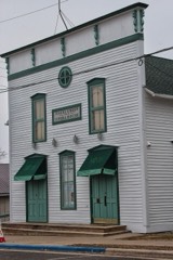 Hazel Green Town Halllisted 1989
Topographic sheets covering this place
7 surveys from 14 printed sheetsMatched by testing this settlement's coordinate against the published boundary of every sheet in the United States Geological Survey's historical collection. Each opens the scanned sheet at the Survey.
- 1902 USGS Mineral Point quadrangle1:125000, 4 printings
- 1952 USGS Cuba City quadrangle1:24000, 3 printings
- 1959 USGS Dubuque quadrangle1:250000
- 1961 USGS Dubuque quadrangle1:250000
- 1962 USGS Dubuque quadrangle1:250000, 2 printings
- 1976 USGS Dubuque quadrangle1:250000
- 1984 USGS Dubuque North quadrangle1:100000, 2 printings
In the county-history sources
18,193 words on this townshipHistory of Grant County, Wisconsin, published 1881 names this settlement in its chapter on Hazel Green Village. These are the passages that mention it, exactly as the scans read.
The only municipal corporation of importance and influence in the town of Hazel Green owes its settlement, building up, progress and wealth to the lead mines, the early source of all advancement and centralization of resources in this portion of the country.
Passage source: History of Grant County, Wisconsin, published 1881.
In those days, the territory surrounding present Hazel Green was known as " Hard Scrabble," and arose from what is represented to have been a desperate contest for the possession of a mine, not unfreqiient at the time of which mention is here made. This took place, it is said, in 1825, at a point on the Branch, some distance beyond the Catholic Church erected in 1846, between James Hardy and Moses Meeker, in which the former was victorious. Those conversant with the melee denominated it the Hardy Scrape, whence it degenerated into " Hard Scrabble," under which it became famous throughout the lead mines, and was so known officially until 1838, when a post office was located at the present village, and a name appropriate, as also more in harmony with the surroundings, given to the infant settlement. Hard Scrabble, however, is still applied by many who flourished when the township was known as such, and decline to be governed by the changed order of affairs.
Passage source: History of Grant County, Wisconsin, published 1881.
During 1825 or 1826, a Mr. Adney came in from the East, and settled upon a claim in Section 13. His daughter, who married Mr. Dixon, of Platteville, in early days, is said to have been the first female to appear in this vicinity. William Billings also name with Mr. Adney. The latter remained some time, and, in 1827, disposed of his claim to a Mr. Floyd, who, in turn, sold to Lewis Curtis. This gentleman brought his family here in 1828. Previous to that year, the Wolcott and Townsend families became residents. In 1826 or 1827, Christian Ebersold settled near the village, and, during 1828 or 1829, erected on the site of Hazel Green. The logs were obtained from land now owned by Mrs. Andrews, and hauled to their place of delivery by Mr. Curtis. The house was near the present residence of John Gribble ; it was sixteen feet square, and built by Wolcott, Townsend and Billings. The country was prairie, except occasional patches of hazel bush, and the cost of the premises can be imagined when the difficulty of procuring lumber, or rather timber, is measured. However, the house was completed, and stood for many years the mark and model of its time. Between this year and 1830, comparatively few settlers, to be considered under the head of permanent, were identified with the body politic.
Passage source: History of Grant County, Wisconsin, published 1881.
Machine-read from a century-old scan, so expect the errors a machine makes: misspelled names, dropped words, stray characters.
Read the whole chapter on Hazel Green Village - it names this place 43 more 43 times.
Fires near this place
6 since 2018Regional context, not property-specific evidence. The federal wildfire occurrence database lists 6 fires within 5 miles of Hazel Green between 2018 and 2020, burning about 6 acres in total. None started naturally. None was recorded as arson. Distance is straight-line from the map coordinates, so a fire counted here may appear on a neighbouring settlement's page as well.
| Reported cause | Fires |
|---|---|
| Missing data/not specified/undetermined | 4 |
| Smoking | 1 |
| Debris and open burning | 1 |
The most recent of them, most recent first, with the day each was reported and the service that recorded it.
| Date | Cause | Size | Reported by | Name on the report |
|---|---|---|---|---|
| 31 May 2019 | Smoking | under an acre | Wisconsin Department of Natural Resources | 191476 |
| 26 April 2020 | Missing data/not specified/undetermined | under an acre | Wisconsin Department of Natural Resources | 202013 |
| 24 April 2018 | Missing data/not specified/undetermined | 5.0 acres | Wisconsin Department of Natural Resources | 2018006 |
| 4 March 2018 | Debris and open burning | 1.0 acres | Wisconsin Department of Natural Resources | 201808 |
| 15 March 2018 | Missing data/not specified/undetermined | under an acre | Wisconsin Department of Natural Resources | 201804 |
| 8 October 2020 | Missing data/not specified/undetermined | under an acre | Wisconsin Department of Natural Resources | 20109 |
Settlements close enough to share some of these fires:
Mines and quarries near this place
10 of 198 shownRegional context, not property-specific evidence. The federal mineral resources record lists 198 workings within 5 miles of Hazel Green: 118 past producers, 66 unknowns, 7 prospects, 6 occurrences. 1 still produces. What was taken out: Lead, Zinc, Lead, Zinc, Zinc, Lead. Distance is straight-line from the map coordinates, so a quarry counted here may appear on a neighbouring settlement's page as well.
| Where | Site | Commodity | Status | Recorded |
|---|---|---|---|---|
| Birbeck Prospect | Iron, Zinc | Prospect | ||
| Birkbeck Mine | Iron, Zinc | Past Producer | ||
| E. G. Weinen & Sons Quarry | Stone, Crushed/Broken | Past Producer | ||
| Johns Quarry | Stone, Crushed/Broken | Past Producer | ||
| Klar Quarry | Stone, Crushed/Broken | Producer | ||
| Limestone Prospect | Stone, Crushed/Broken | Occurrence | ||
| Byrnes Mine | Zinc, Lead | Past Producer | 1927, 1928 | |
| Crawford Mine | Zinc, Lead | Past Producer | 1931, 1932 | |
| Ensch Prospect | Zinc, Lead | Occurrence | ||
| Fox River Valley Mine | Zinc, Lead | Past Producer |
Storms near this place
30 since 1995Regional context, not property-specific evidence. The National Weather Service names Hazel Green in 30 storm reports between 1995 and 2025: 16 thunderstorm wind, 12 hail, 1 flood, 1 flash flood. No death or injury is recorded in these reports. Each account below is quoted exactly as the forecast office filed it, from the NOAA Storm Events Database, and each date opens the federal record of that event.
| When | Event | Place named | Harm | What the report says |
|---|---|---|---|---|
| June 2015 | Thunderstorm Wind | Hazel Green | $110,000 | An estimated wind gust of 65 mph blew down trees and powerlines in and around Hazel Green. The winds also damaged farm buildings and homes. |
| July 2017 | Thunderstorm Wind | Hazel Green | $50,000 | A roof was blown off a commercial building in Hazel Green. |
| July 2025 | Thunderstorm Wind | Hazel Green | $15,000 | Emergency management reported a 70 mph wind gust in Hazel Green as well as a few trees down on power lines. |
| May 1998 | Thunderstorm Wind | Hazel Green | $13,000 | no account filed |
| August 2009 | Thunderstorm Wind | Hazel Green | $12,000 | Emergency manager reported numerous power lines down between the cities of Kieler and Hazel Green. |
| June 1997 | Thunderstorm Wind | Hazel Green | $10,000 | no account filed |
| June 1997 | Thunderstorm Wind | Hazel Green | $6,000 | no account filed |
| July 2011 | Flash Flood | Hazel Green | $2,000 | With up to 10 inches of rain in the area, mud and debris covered portions of Sinsinawa Road southwest of Hazel Green forcing local officials to close the road. |
| May 2008 | Hail | Hazel Green | $2,000 | no account filed |
| August 2016 | Thunderstorm Wind | Hazel Green | $1,000 | Tree limbs were blown down just west of Hazel Green. |
| May 2000 | Hail | Hazel Green | $750 | no account filed |
| May 2017 | Thunderstorm Wind | Hazel Green | $500 | An estimated 60 mph wind gust blew down small tree branches in Hazel Green. |
| August 2007 | Thunderstorm Wind | Hazel Green | $500 | Trees were blown down. |
| May 2004 | Hail | Hazel Green | $500 | no account filed |
| May 2004 | Hail | Hazel Green | $500 | no account filed |
| July 2024 | Thunderstorm Wind | Hazel Green | - | Emergency management measured a 72 mph wind gust in Hazel Green. |
| May 2024 | Thunderstorm Wind | Hazel Green | - | A weather station at the Hazel Green fire department reported a 75 mph wind gust. |
| August 2021 | Thunderstorm Wind | Hazel Green | - | A 60 mph wind gust was measured in Hazel Green. |
| April 2013 | Hail | Hazel Green | - | Nickel to quarter sized hail fell for a couple of minutes in Hazel Green. |
| July 2011 | Hail | Hazel Green | - | Nickel sized hail fell for 5 to 10 minutes. |
| July 2011 | Flood | Hazel Green | - | Heavy rain in Hazel Green caused water to cover portions of County Road W in the eastern part of town. |
| January 2008 | Hail | Hazel Green | - | A Postal Service employee reported hail near Hazel Green penny sized or slightly larger. |
| March 2017 | Hail | Hazel Green | - | no account filed |
| June 2015 | Hail | Hazel Green | - | no account filed |
| May 2008 | Hail | Hazel Green | - | no account filed |
| April 2002 | Thunderstorm Wind | Hazel Green | - | no account filed |
| June 2002 | Hail | Hazel Green | - | no account filed |
| May 1997 | Hail | Hazel Green | - | no account filed |
| April 1995 | Thunderstorm Wind | Hazel Green | - | no account filed |
| April 1995 | Thunderstorm Wind | Hazel Green | - | no account filed |
Nearest settlements
The eight closest, with where each one stands in the county. Distances are straight-line, computed from the Geographic Names Information System coordinates.
| Map | Place | Distance | Sheets |
|---|---|---|---|
| Cuba City | 5.0 miles | 14 | |
| Prairie Corners | 5.2 miles | 17 | |
| Sinsinawa | 5.6 miles | 17 | |
| Saint Rose | 6.3 miles | 14 | |
| Fair Play | 6.7 miles | 17 | |
| Georgetown | 6.8 miles | 14 | |
| Jamestown | 7.1 miles | 17 | |
| Louisburg | 7.2 miles | 17 |
Elsewhere
Matched on this settlement's Geographic Names Information System number rather than its name, so it cannot be a different place of the same name in another state.
| Wikipedia article on Hazel Green | An encyclopaedic summary. Its text is share-alike, so it is linked here rather than copied. |
| Wikidata item Q2533857 | The structured record the population and elevation above come from. Public domain (CC0). |
Provenance
This settlement is recorded in the Geographic Names Information System as feature 1566231. The sheet list is computed by point-in-boundary test against the United States Geological Survey's historical topographic inventory. Both are works of the United States government and carry no copyright under 17 U.S.C. 105.
Wildfire. Short, Karen C. 2022. Spatial wildfire occurrence data for the United States, 1992-2020 [FPA_FOD_20221014]. 6th Edition. Fort Collins, CO: Forest Service Research Data Archive. https://doi.org/10.2737/RDS-2013-0009.6 Collected with United States Government funding and usable without additional permissions or fees.
Mines and quarries. USGS Mineral Resources Data System (MRDS) https://mrdata.usgs.gov/mrds/ A work of the United States government, no copyright under 17 U.S.C. 105.
Storms. NOAA National Centers for Environmental Information, Storm Events Database https://www.ncei.noaa.gov/stormevents/ A work of the United States government, no copyright under 17 U.S.C. 105. Narratives are quoted verbatim from the National Weather Service report and are not edited or summarised.