 Block
Minnesota Junction, Wisconsin
10 topographic sheets cover this place, the earliest surveyed in 1955 and the latest in 1991. It stands in Oak Grove town. It lies in ZIP code area 53032. The Survey maps it on the Horicon quadrangle. It stands 925 feet above sea level.
On record in Minnesota Junction
Buildings and businesses the archive holds for this place. Each opens its own page, with the source record it came from.
On the National Register within a mile 1 record
The National Register names another town for these. They stand within one mile of this settlement's coordinate.
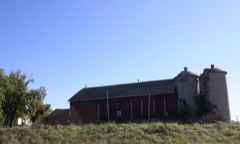 Willard Greenfield Farmsteadlisted 1992 · 0.9 miles away
Topographic sheets covering this place
7 surveys from 10 printed sheetsMatched by testing this settlement's coordinate against the published boundary of every sheet in the United States Geological Survey's historical collection. Each opens the scanned sheet at the Survey.
- 1955 USGS Horicon quadrangle1:62500
- 1957 USGS Madison quadrangle1:250000, 3 printings
- 1960 USGS Madison quadrangle1:250000, 2 printings
- 1975 USGS Horicon NW quadrangle1:24000
- 1980 USGS Horicon quadrangle1:24000
- 1984 USGS Oconomowoc quadrangle1:100000
- 1991 USGS Oconomowoc quadrangle1:100000


In the county-history sources
26,438 words on this townshipThe History of Dodge County, Wisconsin, Containing ... Its Early Settlement, Growth ... an Extensive and Minute Sketch of Its Cities ... War Record, Biographical Sketches, published 1880 names this settlement in its chapter on Oak Grove Town. These are the passages that mention it, exactly as the scans read.
JOJEilj ADAJIS, farmer, Sec. 3; P. 0. Minnesota Junction; born in Warren Co., N. Y., Dec. 2, 1822 ; son of Joseph Adams, who died about 1824 ; his father was from Philadelphia and of old Quaker stock ; in the town of Independence, Penn., is a church built by the Adams family over two hundred years ago. Mr. Joel Adams went to New York City in 1844; WiW there four years ; then went to California by way of the Isthmus, and reached there Oct, 1, 1819 ; kept a bakery in San Francisco ; half the people lived in tents at that time ; afterward went to Marion Co. and went to raising stock ; left California in March, 1860, and went to New York, New Jersey and to Illinois, and came to Oak Grove in June, 1860 and settled on 120 acres and has been engaged in agricultural pursuits ever since ; has now one of the finest creameries and milk-houses in the county; house 16x24 feet and 12 feet to roof; makes about one hundred pounds butter a week, all first-class and finds a very ready market. Married, Oct. 24, 18B0, Elizabeth E. Winter, daughter of Daniel Winter, of New Jersey; have had four children - Mary E., born Sept. 14, 1861 ; George, born Oct. 19, 18G2 ; Frank, born May 28, 1864, and Alice, born April 4, 1866 ; Mary E. died in September, 1862. Mr. Adams has been on the Town Board.
Passage source: The History of Dodge County, Wisconsin, Containing ... Its Early Settlement, Growth ... an Extensive and Minute Sketch of Its Cities ... War Record, Biographical Sketches, published 1880.
W. f. KAMBUSCII, of Rambusch & Mertz, capitalists, insurance, abstracts, etc., Juneau came to Watcrtow'n, Wis., in 1862; in 1867, went to Minneapolis, Minn.; was there four years, and, in 1871, entered the Foreign Department of the Post Office at Washington, under Postmaster Creswell was also appointed one of the Commissioners to Berlin in the interest of the U. S. Post Office Depart ment; in 1874, he came to Juneau and engaged in the abstract business, and finally entered into copart nership with Mr. Mertz in the same business. Married Kmily Curti.ss, daughter of Hiram Curtiss, in 1868 Mr. Rambusch enlisted in September, 1861, in the 5Ist N. Y. V. I., and w;»s honorably discharged in January, 1862. He was also Presidential Elector from Maine. The firm have sterling integrity and great business tact, and through those means have a deserved popularity.
Passage source: The History of Dodge County, Wisconsin, Containing ... Its Early Settlement, Growth ... an Extensive and Minute Sketch of Its Cities ... War Record, Biographical Sketches, published 1880.
F. UEBELi, farmer, Sec. 10 ; P. 0. Minnesota Junction ; born in Germany April 1, 1819 ; came to America in 1850, and to Oak Grove in 1851, and settled on eighty acres, and through his industry and steady perseverance has now a fine farm of 120 acres under good cultivation ; came here with only 50 cents in his pocket; has now a fine brick residence and good, general stock, and everything pertaining to a firstclass farm. Married, in the fall of 185-J:, Eliza Walter ; have had three children - Charley J. (born July 21, 1855), Ernest (born in 1850), Maretz (a child at home). Mr. Uebel gave his aid and support to the war. He was educated and brought up in the Presbyterian Church in the old country.
Passage source: The History of Dodge County, Wisconsin, Containing ... Its Early Settlement, Growth ... an Extensive and Minute Sketch of Its Cities ... War Record, Biographical Sketches, published 1880.
Machine-read from a century-old scan, so expect the errors a machine makes: misspelled names, dropped words, stray characters.
Read the whole chapter on Oak Grove Town - it names this place 7 more 7 times.
Fires near this place
14 since 1992Regional context, not property-specific evidence. The federal wildfire occurrence database lists 14 fires within 5 miles of Minnesota Junction between 1992 and 2020, burning about 757 acres in total. 1 started naturally. 2 were recorded as arson. Distance is straight-line from the map coordinates, so a fire counted here may appear on a neighbouring settlement's page as well.
| Reported cause | Fires |
|---|---|
| Missing data/not specified/undetermined | 5 |
| Equipment and vehicle use | 3 |
| Arson/incendiarism | 2 |
| Debris and open burning | 2 |
| Natural | 1 |
| Recreation and ceremony | 1 |
The most recent of them, most recent first, with the day each was reported and the service that recorded it.
| Date | Cause | Size | Reported by | Name on the report |
|---|---|---|---|---|
| 21 September 2005 | Debris and open burning | 280 acres | Horicon National Wildlife Refuge | DNR CLARK'S DITCH |
| 16 September 2011 | Equipment and vehicle use | under an acre | Horicon National Wildlife Refuge | GATE WF |
| 14 September 2009 | Missing data/not specified/undetermined | 6.0 acres | Horicon National Wildlife Refuge | BURNETT WF |
| 7 July 2012 | Equipment and vehicle use | 42 acres | Horicon National Wildlife Refuge | DEERE WF |
| 10 July 1992 | Arson/incendiarism | 14 acres | Wisconsin Department of Natural Resources | not named |
| 9 April 2009 | Missing data/not specified/undetermined | 8.2 acres | Horicon National Wildlife Refuge | WINCH WF |
| 24 April 2020 | Recreation and ceremony | 30 acres | Wisconsin Department of Natural Resources | 424201 |
| 23 April 2013 | Debris and open burning | under an acre | Horicon National Wildlife Refuge | PHIL WF |
Settlements close enough to share some of these fires:
Mines and quarries near this place
3 within 5 milesRegional context, not property-specific evidence. The federal mineral resources record lists 3 workings within 5 miles of Minnesota Junction: 2 past producers, 1 unknown. None of them still produces. What was taken out: Sand and Gravel, Construction, Stone, Crushed/Broken. Distance is straight-line from the map coordinates, so a quarry counted here may appear on a neighbouring settlement's page as well.
| Where | Site | Commodity | Status | Recorded |
|---|---|---|---|---|
| C C Linck Garage Quarry | Stone, Crushed/Broken | Past Producer | ||
| Dodge County Hwy. Dept. | Sand and Gravel, Construction | Unknown | ||
| Linck-Henes Construction Co., Inc. | Sand and Gravel, Construction | Past Producer |
Nearest settlements
The eight closest, with where each one stands in the county. Distances are straight-line, computed from the Geographic Names Information System coordinates.
| Map | Place | Distance | Sheets |
|---|---|---|---|
| Rolling Prairie | 2.0 miles | 10 | |
| Juneau | 3.3 miles | 10 | |
| Horicon | 3.5 miles | 10 | |
| Burnett | 3.6 miles | 10 | |
| Oak Grove | 5.3 miles | 10 | |
| Buckhorn Corner | 6.9 miles | 8 | |
| Beaver Dam | 7.4 miles | 11 | |
| Beaver Edge | 7.6 miles | 11 |
Elsewhere
Matched on this settlement's Geographic Names Information System number rather than its name, so it cannot be a different place of the same name in another state.
| Wikipedia article on Minnesota Junction | An encyclopaedic summary. Its text is share-alike, so it is linked here rather than copied. |
| Wikidata item Q6868336 | The structured record the population and elevation above come from. Public domain (CC0). |
Provenance
This settlement is recorded in the Geographic Names Information System as feature 1569566. The sheet list is computed by point-in-boundary test against the United States Geological Survey's historical topographic inventory. Both are works of the United States government and carry no copyright under 17 U.S.C. 105.
Wildfire. Short, Karen C. 2022. Spatial wildfire occurrence data for the United States, 1992-2020 [FPA_FOD_20221014]. 6th Edition. Fort Collins, CO: Forest Service Research Data Archive. https://doi.org/10.2737/RDS-2013-0009.6 Collected with United States Government funding and usable without additional permissions or fees.
Mines and quarries. USGS Mineral Resources Data System (MRDS) https://mrdata.usgs.gov/mrds/ A work of the United States government, no copyright under 17 U.S.C. 105.