BlockBefore
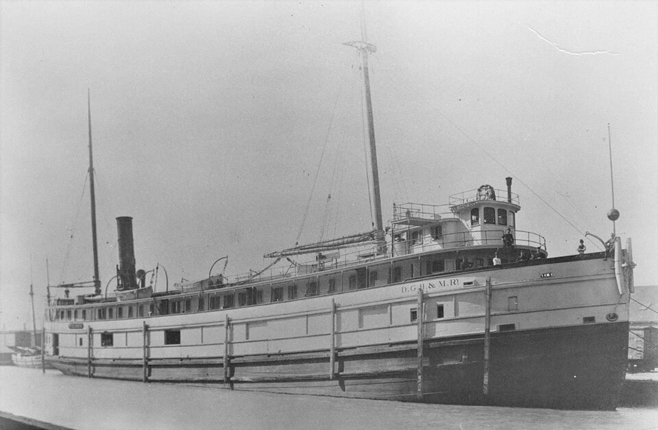
Photograph of Wisconsin
Photograph by Unknown, Public domain. Via Wikimedia Commons.

WISCONSIN shipwreck (iron steamer)

Listed on the National Register of Historic Places in 2009.

From the record

“Wisconsin was an iron-hulled package steamer built in 1881 that sank in 1929 in Lake Michigan off the coast of Kenosha, Wisconsin, United States. In 2009 the shipwreck site was added to the National Register of Historic Places.”

Wikipedia article SS Wisconsin, CC BY-SA 4.0.

One of 25 National Register listings published here for Kenosha County · listed in 2009 · category: Site.

Sources: the Wikipedia article · the case file at the National Archives · the National Register database, National Park Service

The listing

  • What is counted as historic. The nomination lists 1 site as contributing to the listing.
  • Address. 6 mi. SE of Kenosha, WI, in Lake Michigan, Kenosha
  • When was it listed? October 2009
  • Category. site
  • Also known as. Great Lakes Shipwreck Sites of Wisconsin MPS
  • National Register reference number. 09000820 - the number the National Park Service assigned this property when it was listed, and the key its nomination file is catalogued under at the National Archives.

Storms near this property

48 since 1994

Regional context, not property-specific evidence. The National Weather Service names Kenosha, the town this property stands in, in 48 storm reports between 1994 and 2025: 15 thunderstorm wind, 14 hail, 7 lightning, 7 flood. The reports record 1 death. Each account below is quoted exactly as the forecast office filed it, from the NOAA Storm Events Database, and each date opens the federal record of that event.

WhenEvent Place namedHarm What the report says
June 1997LightningKenosha1 killedVictim was riding a bike in heavy rainfall when struck by lightning.
August 2006LightningKenosha$14,000,000Several lightning strikes to several buildings caused structural fires and power outages. A large apartment building, known as St. Catherine Commons, was struck by lightning. The resultant fire severely damaged the building, displacing about 125 residents.
September 2006Flash FloodKenosha$100,000no account filed
May 2004Flash FloodKenosha$100,000no account filed
May 2000LightningKenosha$80,000no account filed
July 2006Thunderstorm WindKenosha$50,000Trees and power lines toppled.
April 1994Thunderstorm WindKenosha$50,000A line of severe thunderstorms raced across southern Wisconsin producing winds up to 80 mph and hail up to the size of golf balls. A barn was downed by intense winds near Mt. Sterling, Crawford County. Otherwise minor property damage along with downed trees and power lines took place.
July 2003LightningKenosha$35,000no account filed
August 2001Thunderstorm WindKenosha$25,000no account filed
July 2006Thunderstorm WindKenosha$20,000Areas of toppled trees and broken tree branches, along with power-line damage, reported across the cities of Kenosha and Pleasant Prairie.
October 1996LightningKenosha$15,000no account filed
July 1997Heavy RainKenosha$10,000Heavy rains in excess of two inches over two hours caused partial collapse of a warehouse roof.
September 2000HailKenosha$10,000no account filed
July 2006Flash FloodKenosha$5,000Between 2020CST and 2035CST, 1.75 inches of rain fell, resulting in flooded farm field and erosion that washed dirt onto roads.
July 1994Thunderstorm WindKenosha$5,000A severe thunderstorm downed trees and power lines and blew down three tents in Kenosha.
May 1996LightningKenosha$5,000no account filed
March 2005Thunderstorm WindKenosha$3,000Billboard and some large trees blown over.
May 1998Thunderstorm WindKenosha$2,000no account filed
September 1997FloodKenosha$2,000no account filed
June 1996Thunderstorm WindKenosha$2,000no account filed
May 2006LightningKenosha$1,000Lightning struck a garage in the city of Kenosha, resulting in a small fire and slight damage. The time is only an estimate, it could have been a hour or two earlier.
May 1999HailKenosha$1,000no account filed
July 1994HailKenosha$500no account filed
August 1995Thunderstorm WindKenosha-A fast moving squall line, originating in Northeast Minnesota, pummled a good part of the eastern two-thirds of Wisconsin with some of the wildest weather seen in 10 years. Feeding on deep tropical moisture, the squall line generated violent winds, hail, lightning, and torrential rainfalls that flooded urban areas. Downed powerlines cut off power to some 140,000 residents at one time or another. In Price County east of Phillips the winds toppled large trees, some which fell on the roofs of homes. Hail up to 1.25 inches in diameter also fell east of Phillips. Large trees were felled west of Tripoli (Oneida County). The powerful winds toppled large trees and/or power lines in Tomahawk, Merrill, and southeast of Merrill, all in Marathon county. Also, two barns were flattened by the intense winds east of Merrill. The violent winds toppled large trees and power lines in Rib Lake (Taylor County). Four inches of rain in one hour resulted in flash flooding which washed out County Highway C south of State Highway 102 near Rib Lake. The extreme winds blew down large trees around Wausau (Marathon County), as well as in Oconto (Oconto County). A lightning strike killed 19 head of cattle near Waupaca (Waupaca County), worth about $30 thousand, as the associated powerful winds blew trees down around Waupaca. Lightning also did some minor fire damage to a home in Hortonville (Outagamie County). Further south, a severe microburst's 75 mph winds did considerable tree and building damage ($160 thousand) in Berlin (Green Lake County). This storm appeared to have developed quickly just north of Berlin, and dumped two inches of rain in just 20 minutes. The storms generated wind gusts to 65 mph as they moved into Winnebago County around Oshkosh. Numerous trees and large limbs were knocked down causing minor damage to 17 homes. Telephone and power lines were also blown down. At the Experimental Aircraft Association museum in Oshkosh a light plane was blown into a window. Lightning strikes did some minor fire damage to a home in Menasha (Winnebago County), and a home in Appleton (Outagamie County). Total damage in Winnebago County was estimated at about $226 thousand. Numerous large tree branches were torn out of trees in Westfield (Marquette County). Powerful winds toppled trees in Ripon (Fond du Lac County) where a home under construction was damaged. Ripon also had urban flooding due to 1.5 inches of rain in less than 30 minutes. Lightning started a fire which damaged a home in Brandon. As the squall line moved south, it's violent winds blew over numerous trees in the Kewauskum/West Bend area, as wells in Germantown, all in Washington County. In this same county, thunderstorm winds blew a barn down north of Allenton. Lightning struck a substation near St. Lawrence, while intense rains of 1.95 inches in less than one hour created urban flooding in West Bend, both in Washington county. In Ozaukee County, urban flooding took place in the Port Washington to Grafton area thanks to 2.25 inches of rain in less than 40 minutes, while lightning damaged a middle school in Port Washington. Further west, the squall line's severe winds toppled large trees in Watertown, and in the city of Jefferson to Fort Atkinson area, all in Jefferson County. Lightning killed eight cows ($11 thousand) on a farm near Cambridge, as well as started a fire which severely damaged a barn northwest of Fort Atkinson, both in Jefferson County. Waukesha County was raked hard as powerful winds toppled many large trees in Butler and Muckwanago, as well as at scattered points in between. Another group of intense wet microbursts tore through Milwaukee County and left a trail of damage over many parts of the the county as winds gusted to at least 60 mph. Hundreds of trees were toppled from River Hills in the north part of Milwaukee County to Oak Creek in the southeast corner. Some schools in the county sustained window damage. Widespread urban flooding was reported throughout the city of Milwaukee. At least 600 basements flooded, as well as numerous underpasses, thanks to rains up to 1.75 inches in 30 minutes. In downtown Milwaukee, the rainfall rate was estimated to be six inches per hour, at one point, although it lasted only a few minutes. Meanwhile, further southwest, violent winds toppled large trees south of Milton (Rock County). Urban flooding was reported in Beloit thanks to the intense rains. Large trees were blown over by powerful winds in Whitewater, around Elkhorn, and in Genoa City, all in Walworth County. A roof was torn off a feeder building in Genoa City, and some siding of a home in Whitewater was ripped off by the thunderstorm winds. The squall line took the shape of a bow echo as it tore through Racine County where hundreds of trees were toppled in the Caledonia to Racine area. Measured gusts at the Racine Yahct Club reached 84 mph as windows were blown out of downtown buildings. Urban flooding occurred in the city of Racine due to the torential rains. A business park in Racine sustained major damage to its buildings. Damage in the City of Racine was estimated at about $100 thousand. A lighting bolt damaged computers in the Racine Department of Transportation Emissions building. As the squall line exited Wisconsin, it's severe winds toppled large trees around a golf course in northeastern Kenosha County.
June 1995Thunderstorm WindKenosha-A strong cold front punched across Wisconsin and affected western and southern counties with numerous severe storms. Some of the storms had torrential rains that left underpasses flooded. A vacant mobile home near Viroqua (Vernon County) was completely destroyed by a downburst. Severe storm winds pushed over large trees in Viroqua and Hillsboro (Vernon County). Dane County was hard hit and sustained about $75,000 in damage to power lines, trees, buildings, and crops. In the Mt. Horeb area (Dane County) a roof was torn off a building, farm equipment overturned, large trees were toppled, and roof shingles and siding on a home were damaged. The area around the Village of Dane (Dane County) also had some roof damage and downed power lines. Two cars were severely damaged in Oregon (Dane County) as large trees fell on them. Locations south of Oregon also had strong winds knock over large trees. The brutal storms packed spotter estimated winds to 70 mph as they rolled through Rock County. A toppled 60-foot tall tree damaged one corner of a Janesville (Rock County) home. Otherwise the storms blew down large trees that did some minor car damage in Evansville (Rock County), tangled power lines, and flipped two small planes on their sides at the Rock County Airport. Over the remainder of southern Wisconsin the severe storms generated powerful winds which blew down large trees in Norwalk (Monroe County); northeast of Eastman (Crawford County); in La Valle, Lake Delton, and Badger (Sauk County); in Richland Center (Richland County); in Castle Rock, Mount Hope, and Fennimore (Grant County); in Ridgeway (Iowa County); southwest of Brooklyn (Green County); in Lake Geneva and Delavan (Walworth County); in Burlington (Racine County); and in the city of Kenosha (Kenosha County). In all, about 17,000 Wisconsin electrical customers lost power for at least a short period of time.
April 1994HailKenosha-A line of severe thunderstorms raced across southern Wisconsin producing winds up to 80 mph and hail up to the size of golf balls. A barn was downed by intense winds near Mt. Sterling, Crawford County. Otherwise minor property damage along with downed trees and power lines took place.
May 2025HailSouth Kenosha-no account filed
July 2006HailKenosha-no account filed
August 2006HailKenosha-no account filed
June 2005HailKenosha-no account filed
May 2004HailKenosha-no account filed
May 2004Thunderstorm WindKenosha-no account filed
May 2004HailKenosha-no account filed
October 2004Thunderstorm WindKenosha-no account filed
November 2003Heavy RainKenosha-no account filed
July 2003Thunderstorm WindKenosha-no account filed
September 2002FloodKenosha-no account filed
June 2002HailKenosha-no account filed
July 2002FloodKenosha-no account filed
May 2001FloodKenosha-no account filed
May 2000HailKenosha-no account filed
September 2000FloodKenosha-no account filed
May 1999FloodKenosha-no account filed
May 1998FloodKenosha-no account filed
July 1995Thunderstorm WindKenosha-no account filed
July 1994Thunderstorm WindKenosha-no account filed

Every storm recorded in Kenosha County

Map coverage status

No historic map-sheet match is published for this property yet. That does not mean no map exists. This record needs a coordinate-quality review before it can be joined to a sheet boundary. Browse the county's mapped places while that work is pending.

Listed places nearby

6 within 8 miles

Other National Register properties close enough to walk or drive between, ordered by distance from this one. Both positions come from the same geocoding pass that matched these properties to their map sheets.

Photograph PropertyDistance Listed
Southport Beach House5.6 miles2003
Manor House6.1 miles1980
Kemper Hall6.1 miles1976
Third Avenue Historic District6.1 miles1988
Frank and Jane Isermann House6.3 miles2004
Anthony and Caroline Isermann House6.3 miles2004

Sources for this property

National Archives recordThe nomination case file for reference 09000820 in Record Group 79.
Wikipedia articleCommunity-written account of this property, licensed CC BY-SA.
Kenosha CountyAll 25 listed properties in this county.

Provenance

  • Listing record. National Park Service National Register of Historic Places, listed-properties dataset, current to 2026-05-22.
  • Map join. Address geocoded through the United States Census geocoder, then tested against the published boundary of every sheet in the USGS Historical Topographic Map Collection.
  • How this page is made. Listing fields come from federal records; map-sheet coverage is a labelled coordinate-to-boundary calculation, not a source-field claim.
  • Storms. NOAA National Centers for Environmental Information, Storm Events Database https://www.ncei.noaa.gov/stormevents/ A work of the United States government, no copyright under 17 U.S.C. 105. Narratives are quoted verbatim from the National Weather Service report and are not edited or summarised.