
BlockBefore
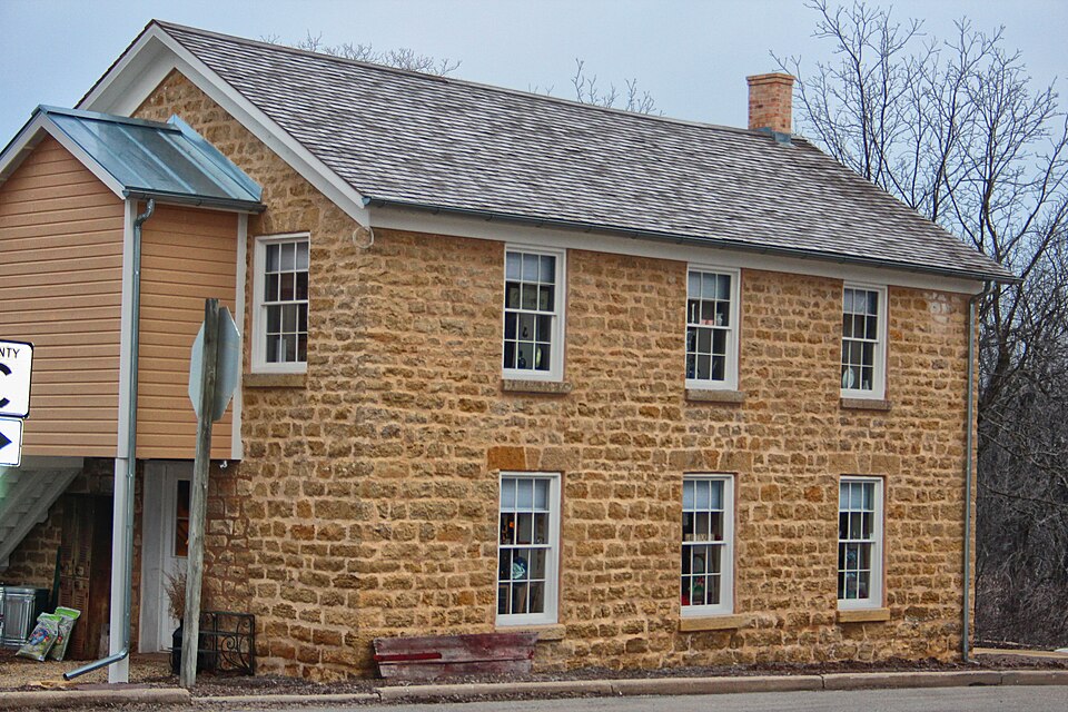
Photograph of Cleveland's Hall and Blacksmith Shop
Photograph by Tgkrause, CC BY-SA 3.0. Via Wikimedia Commons.

Cleveland's Hall and Blacksmith Shop

Built in 1873. Listed on the National Register of Historic Places in 2010.

From the record

“Cleveland's Hall and Blacksmith Shop is a highly intact two-story workshop and meeting hall at the rural crossroad of Attica, Wisconsin, in the town Brooklyn, Green County, Wisconsin, USA. It was added to the National Register of Historic Places in 2010.”

Wikipedia article Cleveland's Hall and Blacksmith Shop, CC BY-SA 4.0.

One of 31 National Register listings published here for Green County · listed in 2010 · category: Building · built in 1873.

Sources: the Wikipedia article · the case file at the National Archives · the National Register database, National Park Service · the Wikipedia article
The listing

  • What is counted as historic. The nomination lists 1 building as contributing to the listing.
  • Address. N7302 County Trunk Hwy X, Brooklyn, 53502
  • When was it listed? January 2010
  • Category. building
  • Town. Brooklyn town
  • When was it built? 1873
  • National Register reference number. 09001220 - the number the National Park Service assigned this property when it was listed, and the key its nomination file is catalogued under at the National Archives.

The ground it stands on

15,113 words

The chapter on Brooklyn Town in History of Green County, Wisconsin, published 1877 names Brooklyn. This is what it says, exactly as the scans read.

Of at least five of the sixteen townships in Green County, the first settlers were by birth the children of Ohio. The first of the Buckeyes in Brooklyn was J. W. Haseltine, who, though he did not begin to make a home there until 1845, bought, in December, 1839, the land on which he is living now. At Mr. Haseltine's solicitation, another Buckeye, W. W. McLaughlin, the first settler in Brooklyn, went to the township in the autumn of 1S42, taking with him a flock of sheep and thirty-four head of cattle. He completed his first cabin and moved into it the first day of November, just five days before "the hard winter" began. His house was on the line of travel from the southern part of the county to the pineries, whither a large part of the produce of the county was hauled; and, though Mrs. Mc Laughlin was the only woman the family saw for three months, men stopped at the house several times every week, and whatever supplies the family needed were obtained from them. The stock was not so easily provided for. Mr. McLaughlin hauled straw fifteen miles, but, in

Passage source: History of Green County, Wisconsin, published 1877.

Among the next settlers were Chas. Sutherland, A. D. Kirkpatrick, Henry Montgomery (whose death the next year is thought to have been the first in the township), and his sons Tracy and Cyrus A., who all came in 1844. Prominent among the settlers of 1845 were Jas. F. Eggleston, Stephen H. Ludlow, Jeremiah Anderson and his son Amos, Wm. R. Smith, sen., Wm. R. Smith., jun., Leroy Hudson, John Sawin, Monroe Carpenter, and Martin Flood. Most of these settlers were in the northern and eastern parts of the town. They went to mill and to market in Dane and Rock Counties much oftener than in Green, and when they were sick their hopes centered in Dr. Fox in Dane County. Many of them lived on Jug Prairie, a fertile prairie in Rock County and the eastern half of Brooklyn, which derives its name from a remark of one of the first settlers who went one day to Rock County to trade. So many of his neighbors had sent by him for vinegar and molasses that by the time he reached his destination he had nearly a dozen jugs in his wagon. To a joke of the bystanders, as he drove up to the store, he replied, oh, yes, I come from jug prairie ; and in spite of the effort of the good people on the prairie to change the name to temperance, the name jug has stuck ever since.

Passage source: History of Green County, Wisconsin, published 1877.

Machine-read from a century-old scan, so expect the errors a machine makes: misspelled names, dropped words, stray characters.

Read the whole chapter on Brooklyn Town - 15,113 words on its settlement, mills, schools and churches.

Fires near this property

9 since 2014

Regional context, not property-specific evidence. The federal wildfire occurrence database lists 9 fires within 5 miles of Cleveland's Hall and Blacksmith Shop between 2014 and 2020, burning about 74 acres in total. None started naturally. None was recorded as arson. Distance is straight-line from the map coordinates, so a fire counted here may appear on a neighbouring settlement's page as well.

Reported cause Fires
Debris and open burning7
Missing data/not specified/undetermined2

The most recent of them, most recent first, with the day each was reported and the service that recorded it.

DateCause SizeReported by Name on the report
29 May 2018Missing data/not specified/undeterminedunder an acreWisconsin Department of Natural Resources201829
5 April 2018Debris and open burning2.0 acresWisconsin Department of Natural Resources3366
30 April 2018Debris and open burningunder an acreWisconsin Department of Natural Resources201826
30 April 2018Missing data/not specified/undetermined1.0 acresWisconsin Department of Natural Resources201825
28 April 2018Debris and open burning2.0 acresWisconsin Department of Natural Resources201823
23 April 2014Debris and open burning65 acresWisconsin Department of Natural ResourcesDODGEVILLE CO-OP 8
1 April 2020Debris and open burning4.0 acresWisconsin Department of Natural Resources3661
31 March 2019Debris and open burningunder an acreWisconsin Department of Natural Resources201925

Every fire recorded in Green County

Mines and quarries near this property

5 within 5 miles

Regional context, not property-specific evidence. The federal mineral resources record lists 5 workings within 5 miles of Cleveland's Hall and Blacksmith Shop: 3 past producers, 1 unknown, 1 producer. 1 still produces. What was taken out: Stone, Crushed/Broken, Sand and Gravel, Construction. Distance is straight-line from the map coordinates, so a quarry counted here may appear on a neighbouring settlement's page as well.

Where SiteCommodity StatusRecorded
Schlapbach PitSand and Gravel, ConstructionProducer
Schlapback PitSand and Gravel, ConstructionUnknown
Kauk QuarryStone, Crushed/BrokenPast Producer
Thickpenny QuarryStone, Crushed/BrokenPast Producer
WaelchliStone, Crushed/BrokenPast Producer

Every working recorded in Green County

Storms near this property

1 since 1995

Regional context, not property-specific evidence. The National Weather Service names Brooklyn, the town this property stands in, in 1 storm report in 1995: 1 thunderstorm wind. No death or injury is recorded in these reports. Each account below is quoted exactly as the forecast office filed it, from the NOAA Storm Events Database, and each date opens the federal record of that event.

WhenEvent Place namedHarm What the report says
June 1995Thunderstorm WindBrooklyn-no account filed

Every storm recorded in Green County

Map coverage status

No historic map-sheet match is published for this property yet. That does not mean no map exists. This record needs a coordinate-quality review before it can be joined to a sheet boundary. Browse the county's mapped places while that work is pending.

Listed places nearby

2 within 8 miles

Other National Register properties close enough to walk or drive between, ordered by distance from this one. Both positions come from the same geocoding pass that matched these properties to their map sheets.

Photograph PropertyDistance Listed
John C. and Barbara Steinman House6.1 miles2003
Freitag Homestead6.9 miles2005

Sources for this property

National Archives recordThe nomination case file for reference 09001220 in Record Group 79.
Wikipedia articleCommunity-written account of this property, licensed CC BY-SA.
Green CountyAll 31 listed properties in this county.

Provenance

  • Listing record. National Park Service National Register of Historic Places, listed-properties dataset, current to 2026-05-22.
  • Map join. Address geocoded through the United States Census geocoder, then tested against the published boundary of every sheet in the USGS Historical Topographic Map Collection.
  • How this page is made. Listing fields come from federal records; map-sheet coverage is a labelled coordinate-to-boundary calculation, not a source-field claim.
  • Wildfire. Short, Karen C. 2022. Spatial wildfire occurrence data for the United States, 1992-2020 [FPA_FOD_20221014]. 6th Edition. Fort Collins, CO: Forest Service Research Data Archive. https://doi.org/10.2737/RDS-2013-0009.6 Collected with United States Government funding and usable without additional permissions or fees.
  • Mines and quarries. USGS Mineral Resources Data System (MRDS) https://mrdata.usgs.gov/mrds/ A work of the United States government, no copyright under 17 U.S.C. 105.
  • Storms. NOAA National Centers for Environmental Information, Storm Events Database https://www.ncei.noaa.gov/stormevents/ A work of the United States government, no copyright under 17 U.S.C. 105. Narratives are quoted verbatim from the National Weather Service report and are not edited or summarised.