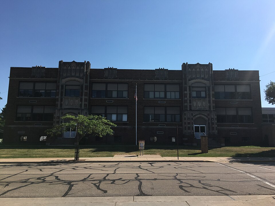
Built in 1918. Listed on the National Register of Historic Places in 2018.
From the record
“When the Milwaukee, Lake Shore & Western railroad reached New London, it was found necessary to secure the services of some one familiar with the northern country, one who had a knowledge of surveying, and, withal, possessed good judgment. The next place the road was to strike was Clintonville, and one day a carriage load of railroad officials drove into town.”
History of Waupaca County, Wisconsin (1890). Machine-read text.
One of 25 National Register listings published here for Waupaca County · listed in 2018 · category: Building · built in 1918.
National Register reference number. 100002941 - assigned by the National Park Service when the property was listed.
The ground it stands on
3,268 words
The chapter on Clintonville City in History of Waupaca County, Wisconsin, published 1890 names Clintonville. This is what it says, exactly as the scans read.
In the Fall of 1881 the writer was in the little backwoods village of Clintonville. It was then a small, unpretentious burgh, giving no indications of much future smartness. In the Spring of 1890, he paid a second visit, and met with a surprise. In nine years it had become a pleasant city, with a population of nearly 2,000. It is full of live, energetic business men, ^lo will make it a successful rival of its sister towns, if money and brains can doit.
We do not believe that we can conclude our sketch of Clintonville more acceptably than by copying two chapters from that spicy sheet. The Dual-City Tribune, by Frank H. Brady, who has laid us under many obligations for kind attentions paid during our recent visit to his cit3^ Mr. Brady is a grandson of Mr. Clinton, a sketch of whose life is here given :
Regional context, not property-specific
evidence. The
federal wildfire occurrence database
lists 78 fires within 5 miles of Clintonville High School
between 1993 and 2020, burning about 113 acres in total. None started naturally. 4 were recorded as arson.
Distance is straight-line from the map coordinates, so a fire counted
here may appear on a neighbouring settlement's page as well.
Reported cause
Fires
Debris and open burning
41
Equipment and vehicle use
11
Missing data/not specified/undetermined
10
Recreation and ceremony
4
Arson/incendiarism
4
Misuse of fire by a minor
3
Fireworks
2
Other causes
1
Smoking
1
Power generation/transmission/distribution
1
The most recent of
them, most recent first, with the day each was reported and the service
that recorded it.
Regional context, not property-specific
evidence. The federal mineral resources record lists
4 workings within 5 miles of Clintonville High School: 3 past producers, 1 producer.
1 still produces. What was taken out: Sand and Gravel, Construction. Distance is straight-line from the
map coordinates, so a quarry counted here may appear on a neighbouring
settlement's page as well.
Regional context, not property-specific
evidence. The National Weather Service names
Clintonville, the town this property stands in, in 45 storm reports between 1995 and 2026: 23 thunderstorm wind, 16 hail, 2 tornado, 2 flash flood.
No death or injury is recorded in these reports. Each account below is quoted exactly as the forecast office
filed it, from the NOAA Storm Events Database, and each date
opens the federal record of that event.
Rainfall amounts of 2 to 3 inches in a short time caused US Highway 45 to close at the intersection of County Road O south of Clintonville due to flash flooding. The time of this report is an estimate based on radar data.
A tornado briefly touched down south of Clintonville at 5:32 PM|CDT, moving east-northeast before dissipating at 5:34 PM CDT. The tornado was spotted by the local fire department and tracked over mainly open areas with little to no damage indicators. The only damage indicators were disturbances to crops on satellite analysis. Total path length is estimated to be 1.32 miles long, with a width of 80 yards. Path estimated based on radar and satellite imagery.
Nickel size hail, torrential rain and wind gusts estimated at 45 mph were reported by a spotter in Clintonville as thunderstorms moved through the area.
Heavy rain fell across northeast Waupaca County causing rivers and streams to overflow their banks in some locations, washing out culverts and flooding County Highway C near Clintonville. Storm total rainfall in northern Waupaca County was generally in excess of 3 inches. The highest recorded total was 4.73 inches at Clintonville.
No historic map-sheet match is published
for this property yet. That does not mean no map exists. This record needs
a coordinate-quality review before it can be joined to a sheet boundary.
Browse the county's mapped places while that work is
pending.
Listed places nearby
1 within 8 miles
Other National Register properties close
enough to walk or drive between, ordered by distance from this one. Both
positions come from the same geocoding pass that matched these properties
to their map sheets.
Listing record. National Park Service National Register of Historic Places, listed-properties dataset, current to 2026-05-22.
Map join. Address geocoded through the United States Census geocoder, then tested against the published boundary of every sheet in the USGS Historical Topographic Map Collection.
How this page is made. Listing fields come from federal records; map-sheet coverage is a labelled coordinate-to-boundary calculation, not a source-field claim.
Wildfire. Short, Karen C. 2022. Spatial wildfire occurrence data for the United States, 1992-2020 [FPA_FOD_20221014]. 6th Edition. Fort Collins, CO: Forest Service Research Data Archive. https://doi.org/10.2737/RDS-2013-0009.6 Collected with United States Government funding and usable without additional permissions or fees.
Mines and quarries. USGS Mineral Resources Data System (MRDS) https://mrdata.usgs.gov/mrds/ A work of the United States government, no copyright under 17 U.S.C. 105.
Storms. NOAA National Centers for Environmental Information, Storm Events Database https://www.ncei.noaa.gov/stormevents/ A work of the United States government, no copyright under 17 U.S.C. 105. Narratives are quoted verbatim from the National Weather Service report and are not edited or summarised.
 Block