FRED W. DE QITINE was bom in Calumet Village,\his county, Oct. 30, 1853; in September, 1854, his father, Louis De Quine, died, and he came with his mother to Fond du Lao in 1855; she resides at No. 27 Doty street ; Mr. D. attended school until April 4, 1870, when he served three years' apprentice.ship as a machinist, and has worked ever since at that trade in Fond du Lac; he is foreman of the TTnion Iron Works ; is a Turner, and a member of the I, 0. 0. F. Lodge.
JOHN W. DIIiLiON, photographer; was born in London, England, Oct. 27. 1847, and came to America when 12 years of age, living in New York City until July 27, 18G4, when he enlisted in Battery B, 5th U. S. A., for three years, as a musician or bugler ; at the expiration of his term of service in 1807, he went to Chicago, thence to Bloomington and Lincoln, finally, coming to Fond du Lac the same year, and engaging in his present business, that of a photographer. He was married in Fond du Lac Feb. 25, 1873, to Ella M., a native of Ma'nitowoc Co., daughter of Evander Soper, one of the earliest settlers of Wisconsin ; they have two children - -Frank Earle and Harry Walton. Mr. D. belongs to the Masonic, Odd Fellows and Knights of Pythias Lodges of Fond du Lac, and has been Alderman from the Eighth Ward since the spring of 187i*.
Regional context, not property-specific
evidence. The
federal wildfire occurrence database
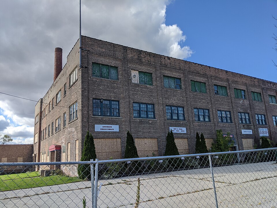
lists 18 fires within 5 miles of Northern Casket Company Building
between 1993 and 2020, burning about 516 acres in total. None started naturally. 1 was recorded as arson.
Distance is straight-line from the map coordinates, so a fire counted
here may appear on a neighbouring settlement's page as well.
Reported cause
Fires
Missing data/not specified/undetermined
10
Debris and open burning
3
Arson/incendiarism
1
Smoking
1
Power generation/transmission/distribution
1
Misuse of fire by a minor
1
Equipment and vehicle use
1
The most recent of
them, most recent first, with the day each was reported and the service
that recorded it.
Regional context, not property-specific
evidence. The federal mineral resources record lists
4 workings within 5 miles of Northern Casket Company Building: 3 unknowns, 1 producer.
1 still produces. What was taken out: Sand and Gravel, Construction, Stone, Crushed/Broken, Stone. Distance is straight-line from the
map coordinates, so a quarry counted here may appear on a neighbouring
settlement's page as well.
Regional context, not property-specific
evidence. The National Weather Service names
Fond du Lac, the town this property stands in, in 71 storm reports between 1994 and 2025: 24 thunderstorm wind, 20 hail, 13 lightning, 6 flash flood.
The reports record 1 injury. Each account below is quoted exactly as the forecast office
filed it, from the NOAA Storm Events Database, and each date
opens the federal record of that event.
A flash flood occurred across the city of Fond du Lac that resulted in widespread basement flooding, and minor road damage consisting of gravel and shoulder washouts. Water depths on some streets reached 2 to 4 feet. A coop observer in the city measured 3.9 inches of rain while the storms were rolling through the city.
Some flash flooding of streets in Fond du Lac and rural roads with some road closures. |I-41 lanes closed due to flooding between Military Rd. and Highway 151. A few cars stranded in floodwaters in a low spot in the city of Fond du Lac.
Thunderstorm wind gusts measured at 58 mph (50 knots) blew a tree down on a garage on the east side of Fond Du Lac, and also brought down a few power lines.
A lightning strike caused a fire in the attic of a home that was quickly extinguished by firefighters. There was severe damage to the home's electrical system.
Lightning struck a city of Fond du Lac home. There was no fire, but the home's electrical wiring was damaged, and a hole was punched in the roof of a porch.
Flash flooding closed some roads and washed out some gravel shoulders on the south side of the city of Fond du Lac. Rainfall amounts of 3 to 5 inches were noted, based on WSR-88D estimates and spotter reports. Water depths on US Hwy 41 between 151 and 175 reached 4 to 5 feet.
Flash flooding of streets in sections of Fond du Lac after 2 to 3 inches of rain. Some roads with a depth of 3 feet of water. Intersections of National Ave. and Division St. and National Ave. and Scott St. were closed due to the flood waters.
Isolated severe thunderstorms produced damaging winds affecting trees and power lines and dropped hail up to 1.5 inches in diameter over southwest and east-central Wisconsin.
Fond Du Lac County sheriff deputies reported large tree limbs and power lines blown down by damaging thunderstorm winds estimated at 50 knots (58 mph).
Severe thunderstorms with strong wind gusts produced damage across central Fond Du Lac County. The damaging winds downed power lines and trees, knocking out power to businesses and homes on the west side of the city of Fond Du Lac.
No historic map-sheet match is published
for this property yet. That does not mean no map exists. This record needs
a coordinate-quality review before it can be joined to a sheet boundary.
Browse the county's mapped places while that work is
pending.
Listed places nearby
6 within 8 miles
Other National Register properties close
enough to walk or drive between, ordered by distance from this one. Both
positions come from the same geocoding pass that matched these properties
to their map sheets.
Listing record. National Park Service National Register of Historic Places, listed-properties dataset, current to 2026-05-22.
Map join. Address geocoded through the United States Census geocoder, then tested against the published boundary of every sheet in the USGS Historical Topographic Map Collection.
How this page is made. Listing fields come from federal records; map-sheet coverage is a labelled coordinate-to-boundary calculation, not a source-field claim.
Wildfire. Short, Karen C. 2022. Spatial wildfire occurrence data for the United States, 1992-2020 [FPA_FOD_20221014]. 6th Edition. Fort Collins, CO: Forest Service Research Data Archive. https://doi.org/10.2737/RDS-2013-0009.6 Collected with United States Government funding and usable without additional permissions or fees.
Mines and quarries. USGS Mineral Resources Data System (MRDS) https://mrdata.usgs.gov/mrds/ A work of the United States government, no copyright under 17 U.S.C. 105.
Storms. NOAA National Centers for Environmental Information, Storm Events Database https://www.ncei.noaa.gov/stormevents/ A work of the United States government, no copyright under 17 U.S.C. 105. Narratives are quoted verbatim from the National Weather Service report and are not edited or summarised.
 Block