 Block
From the record
One of 60 National Register listings published here for La Crosse County · listed in 2022 · category: Building.
Sources: the National Register database, National Park Service
Listed on the National Register of Historic Places in 2022.
One of 60 National Register listings published here for La Crosse County · listed in 2022 · category: Building.
Sources: the National Register database, National Park Service
Regional context, not property-specific evidence. The federal wildfire occurrence database lists 11 fires within 5 miles of Derwood and Myrtle Trimbell House between 1992 and 2020, burning about 5 acres in total. None started naturally. None was recorded as arson. Distance is straight-line from the map coordinates, so a fire counted here may appear on a neighbouring settlement's page as well.
| Reported cause | Fires |
|---|---|
| Missing data/not specified/undetermined | 9 |
| Equipment and vehicle use | 2 |
The most recent of them, most recent first, with the day each was reported and the service that recorded it.
| Date | Cause | Size | Reported by | Name on the report |
|---|---|---|---|---|
| 14 August 2020 | Missing data/not specified/undetermined | 2.0 acres | Wisconsin Department of Natural Resources | 81420 |
| 18 June 2020 | Missing data/not specified/undetermined | under an acre | Wisconsin Department of Natural Resources | 2020053 |
| 17 June 2020 | Missing data/not specified/undetermined | under an acre | Wisconsin Department of Natural Resources | 2020052 |
| 14 June 2020 | Equipment and vehicle use | under an acre | Wisconsin Department of Natural Resources | 2002887 |
| 1 May 2020 | Missing data/not specified/undetermined | under an acre | Wisconsin Department of Natural Resources | 2020029 |
| 28 April 2018 | Missing data/not specified/undetermined | under an acre | Wisconsin Department of Natural Resources | 2018035 |
| 27 April 2018 | Missing data/not specified/undetermined | under an acre | Wisconsin Department of Natural Resources | 2018034 |
| 24 April 2018 | Missing data/not specified/undetermined | under an acre | Wisconsin Department of Natural Resources | 42418 |
Regional context, not property-specific evidence. The federal mineral resources record lists 3 workings within 5 miles of Derwood and Myrtle Trimbell House: 3 past producers. None of them still produces. What was taken out: Stone, Crushed/Broken. Distance is straight-line from the map coordinates, so a quarry counted here may appear on a neighbouring settlement's page as well.
| Where | Site | Commodity | Status | Recorded |
|---|---|---|---|---|
| Bangor Quarry | Stone, Crushed/Broken | Past Producer | ||
| Klos Quarry | Stone, Crushed/Broken | Past Producer | ||
| Ronskog Quarry | Stone, Crushed/Broken | Past Producer |
Regional context, not property-specific evidence. The National Weather Service names West Salem, the town this property stands in, in 48 storm reports between 1998 and 2024: 22 thunderstorm wind, 21 hail, 3 heavy rain, 1 tornado. The reports record 14 injuries. Each account below is quoted exactly as the forecast office filed it, from the NOAA Storm Events Database, and each date opens the federal record of that event.
| When | Event | Place named | Harm | What the report says |
|---|---|---|---|---|
| June 1998 | Thunderstorm Wind | West Salem | 13 hurt, $20,000 | Circus tent collapsed at fairgrounds. 500 people were in tent. 13 injured. |
| May 1998 | Tornado (F0) | West Salem | 1 hurt, $40,000 | no account filed |
| June 2007 | Hail | West Salem | $100,000 | Large hail damaged cars and homes. |
| June 2007 | Hail | West Salem | $100,000 | no account filed |
| May 2017 | Thunderstorm Wind | West Salem | $70,000 | A path of straight line wind damage was found from the east of Lake Neshonoc to northwest of Bangor. Approximately 250 trees were damaged or uprooted, a barn was destroyed, another barn lost part of its roof and there was minor damage to a house and garage. |
| July 2023 | Hail | West Salem | $65,000 | Public reported tennis ball sized hail and broken windows in West Salem. |
| July 2023 | Hail | West Salem | $50,000 | Law enforcement reported baseball hail near West Salem. |
| July 2023 | Hail | West Salem | $50,000 | Public reported tea cup sized hail near West Salem via picture. |
| June 2007 | Hail | West Salem | $50,000 | no account filed |
| July 2023 | Thunderstorm Wind | West Salem | $40,000 | Public reported several fallen trees near West Salem. |
| July 2023 | Thunderstorm Wind | West Salem | $35,000 | Public reported damage to large trees near West Salem. |
| July 2023 | Hail | West Salem | $35,000 | Public reported hen egg sized hail near West Salem. |
| July 2023 | Hail | West Salem | $35,000 | Public reported tennis ball sized hail in West Salem. |
| July 1998 | Thunderstorm Wind | West Salem | $14,000 | no account filed |
| August 2016 | Thunderstorm Wind | West Salem | $10,000 | Numerous trees were blown down in West Salem along with power lines. A tree was split in half with the section that came down blocking a part of the street. Nearly 1,500 residences were without power after the storm. |
| June 2019 | Thunderstorm Wind | West Salem | $5,000 | In West Salem, thunderstorm winds caused two trees to lean over onto power lines and blew down a large tree limb that was partially rotted. |
| August 2007 | Thunderstorm Wind | West Salem | $3,500 | Tree down on a car in veterns park. |
| June 2021 | Thunderstorm Wind | West Salem | $3,000 | Trees were blown down and a large tree was split in half just west of West Salem. |
| June 2014 | Thunderstorm Wind | West Salem | $3,000 | A 2 foot diameter tree was blown down onto a garage in West Salem. |
| June 2007 | Hail | West Salem | $2,000 | no account filed |
| June 2019 | Thunderstorm Wind | West Salem | $1,000 | A large tree branch and several smaller branches were blown down in West Salem. |
| July 2003 | Thunderstorm Wind | West Salem | $1,000 | no account filed |
| July 2002 | Thunderstorm Wind | West Salem | $1,000 | no account filed |
| June 2001 | Hail | West Salem | $1,000 | no account filed |
| September 2007 | Thunderstorm Wind | West Salem | $500 | no account filed |
| June 2008 | Thunderstorm Wind | West Salem | $400 | A large tree was blown down on Garland Street in West Salem. |
| June 2010 | Thunderstorm Wind | West Salem | $250 | Thunderstorm winds blew several tree branches down taking out about a third of the tree. The diameter of the branches was measured at 10 inches. |
| May 2024 | Thunderstorm Wind | West Salem | - | A trained spotter reported tree damage along Highway 16. |
| July 2023 | Thunderstorm Wind | West Salem | - | An NWS employee reported fallen trees on Lake Neshonoc. |
| May 2022 | Hail | West Salem | - | Quarter sized hail was reported west of West Salem. |
| June 2021 | Flood | West Salem | - | Locally heavy rain caused street flooding to occur in West Salem. |
| June 2021 | Heavy Rain | West Salem | - | In West Salem, 2.17 inches of rain fell. |
| June 2020 | Hail | West Salem | - | Quarter sized hail fell just west of West Salem. |
| July 2015 | Thunderstorm Wind | West Salem | - | A ten foot trailer was blown off of State Highway 16 north of West Salem. |
| May 2013 | Heavy Rain | West Salem | - | In West Salem, a total of 2.69 inches of rain fell. |
| May 2013 | Heavy Rain | West Salem | - | In West Salem, 1.79 inches of rain fell in 45 minutes. |
| July 2013 | Hail | West Salem | - | Half dollar sized hail fell just west of West Salem. |
| July 2013 | Hail | West Salem | - | Hail up to 2 inches in diameter fell in West Salem. |
| September 2011 | Thunderstorm Wind | West Salem | - | An estimated wind gust of 60 miles per hour occurred in West Salem. |
| July 2008 | Thunderstorm Wind | West Salem | - | A National Weather Service employee estimated a wind gust of 52 knots and measured 1.20 inches of rain. |
| August 2020 | Hail | West Salem | - | no account filed |
| August 2020 | Hail | West Salem | - | no account filed |
| September 2014 | Hail | West Salem | - | no account filed |
| April 2011 | Hail | West Salem | - | no account filed |
| June 2010 | Hail | West Salem | - | no account filed |
| June 2007 | Thunderstorm Wind | West Salem | - | no account filed |
| June 2001 | Hail | West Salem | - | no account filed |
| June 2001 | Hail | West Salem | - | no account filed |
No historic map-sheet match is published for this property yet. That does not mean no map exists. This record needs a coordinate-quality review before it can be joined to a sheet boundary. Browse the county's mapped places while that work is pending.
Other National Register properties close enough to walk or drive between, ordered by distance from this one. Both positions come from the same geocoding pass that matched these properties to their map sheets.
| Photograph | Property | Distance | Listed |
|---|---|---|---|
| Hamlin Garland House | 0.2 miles | 1971 | |
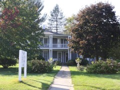 | Palmer Brother's Octagons | 0.3 miles | 1979 |
| Bangor Commercial Historic District | 4.4 miles | 2022 | |
 | Mindoro Cut | 5.1 miles | 2007 |
 | Smith Valley School | 6.2 miles | 1981 |
| La Crosse County School of Agriculture and Domestic Economy | 7.7 miles | 1987 |
| National Archives record | The nomination case file for reference 100007696 in Record Group 79. |
| La Crosse County | All 60 listed properties in this county. |