 Block
From the record
One of 30 National Register listings published here for Washington County · listed in 2023 · category: Building.
Sources: the National Register database, National Park Service
Listed on the National Register of Historic Places in 2023.
One of 30 National Register listings published here for Washington County · listed in 2023 · category: Building.
Sources: the National Register database, National Park Service
Regional context, not property-specific evidence. The federal wildfire occurrence database lists 17 fires within 5 miles of Tischer, Wilhelm Blacksmith Shop between 2018 and 2020, burning about 11 acres in total. None started naturally. 2 were recorded as arson. Distance is straight-line from the map coordinates, so a fire counted here may appear on a neighbouring settlement's page as well.
| Reported cause | Fires |
|---|---|
| Debris and open burning | 6 |
| Missing data/not specified/undetermined | 5 |
| Arson/incendiarism | 2 |
| Recreation and ceremony | 2 |
| Power generation/transmission/distribution | 1 |
| Equipment and vehicle use | 1 |
The most recent of them, most recent first, with the day each was reported and the service that recorded it.
| Date | Cause | Size | Reported by | Name on the report |
|---|---|---|---|---|
| 4 August 2018 | Debris and open burning | 1.0 acres | Wisconsin Department of Natural Resources | 180850 |
| 19 August 2018 | Missing data/not specified/undetermined | under an acre | Wisconsin Department of Natural Resources | 1801269 |
| 19 July 2018 | Power generation/transmission/distribution | under an acre | Wisconsin Department of Natural Resources | 1801111 |
| 23 June 2019 | Equipment and vehicle use | under an acre | Wisconsin Department of Natural Resources | 190704 |
| 4 April 2019 | Debris and open burning | under an acre | Wisconsin Department of Natural Resources | 190468 |
| 30 April 2018 | Missing data/not specified/undetermined | under an acre | Wisconsin Department of Natural Resources | 2018057 |
| 3 April 2020 | Recreation and ceremony | 1.0 acres | Wisconsin Department of Natural Resources | 200365 |
| 22 April 2019 | Debris and open burning | under an acre | Wisconsin Department of Natural Resources | 2019064 |
Regional context, not property-specific evidence. The federal mineral resources record lists 1 working within 5 miles of Tischer, Wilhelm Blacksmith Shop: 1 past producer. None of them still produces. What was taken out: Sand and Gravel, Construction. Distance is straight-line from the map coordinates, so a quarry counted here may appear on a neighbouring settlement's page as well.
| Where | Site | Commodity | Status | Recorded |
|---|---|---|---|---|
| H.F. Prahl Corp. Pit | Sand and Gravel, Construction | Past Producer |
Regional context, not property-specific evidence. The National Weather Service names Jackson, the town this property stands in, in 26 storm reports between 1996 and 2023: 11 hail, 10 thunderstorm wind, 2 tornado, 2 funnel cloud. No death or injury is recorded in these reports. Each account below is quoted exactly as the forecast office filed it, from the NOAA Storm Events Database, and each date opens the federal record of that event.
| When | Event | Place named | Harm | What the report says |
|---|---|---|---|---|
| April 2006 | Hail | Jackson | $1,990,000 | no account filed |
| June 1996 | Thunderstorm Wind | Jackson | $18,000 | no account filed |
| September 2005 | Thunderstorm Wind | Jackson | $10,000 | Large trees and power lines down. |
| July 2002 | Thunderstorm Wind | Jackson | $10,000 | no account filed |
| August 2018 | Thunderstorm Wind | Jackson | $5,000 | Tree damage concentrated in the Jackson area including one large uprooted tree. A parking sign with a concrete base was tipped over. |
| March 2002 | Lightning | Jackson | $5,000 | Lightning hit a home's satellite dish and sent a current into the home, resulting in damage to a computer system and all major appliances and household wiring. |
| June 2008 | Thunderstorm Wind | Jackson | - | Powerful thunderstorms winds knocked down a few large trees. |
| June 2007 | Tornado (EF0) | Jackson | - | A brief, weak tornado spun up about 2.12 miles south-southwest (198 degrees) of the city of Jackson, or about 2.4 miles north of the village of Richfield (just west of STH 45), or about 0.23 miles southwest (225 degrees) of the STH 45 overpass with Western Ave. It was stationary during its 20-30 seconds life-span, based on trained spotter accounts. It resulted in only matted-down grasses. No EF-Scale Damage Indicator (DI) could be used. Specific lat/lon info is: N43.29313 W88.19027. Estimated average path width was about 20 yards. Estimated wind speed is 56-61 knots (65-70 mph). |
| August 2006 | Thunderstorm Wind | Jackson | - | Trees down. |
| September 2005 | Thunderstorm Wind | Jackson | - | Large picnic table and chairs scattered and thrown 20 feet by wind gusts, and large trees down. |
| September 2005 | Thunderstorm Wind | Jackson | - | Measured by the Fox TV-6 school network site at Kettle Moraine High School. |
| June 2004 | Tornado (F0) | Jackson | - | A very brief F0 tornado (50-60 mph) spun up 4 miles north-northeast of Jackson in an open rural area just north of STH 143 and east of CTH G, or 0.6 miles northwest of Keowns. The tornado traveled southeast 0.1 miles and dissipated. No damage was reported. |
| April 2023 | Hail | Jackson | - | no account filed |
| April 2020 | Hail | Jackson | - | no account filed |
| April 2020 | Hail | Jackson | - | no account filed |
| August 2017 | Hail | Jackson | - | no account filed |
| August 2015 | Hail | Jackson | - | no account filed |
| May 2014 | Hail | Jackson | - | no account filed |
| August 2011 | Funnel Cloud | Jackson | - | no account filed |
| May 2011 | Hail | Jackson | - | no account filed |
| August 2011 | Funnel Cloud | Jackson | - | no account filed |
| June 2006 | Thunderstorm Wind | Jackson | - | no account filed |
| September 2006 | Hail | Jackson | - | no account filed |
| August 2006 | Thunderstorm Wind | Jackson | - | no account filed |
| August 2006 | Hail | Jackson | - | no account filed |
| June 2005 | Hail | Jackson | - | no account filed |
No historic map-sheet match is published for this property yet. That does not mean no map exists. This record needs a coordinate-quality review before it can be joined to a sheet boundary. Browse the county's mapped places while that work is pending.
Other National Register properties close enough to walk or drive between, ordered by distance from this one. Both positions come from the same geocoding pass that matched these properties to their map sheets.
| Photograph | Property | Distance | Listed |
|---|---|---|---|
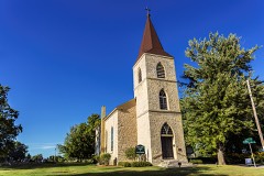 | Christ Evangelical Church | 4.3 miles | 1983 |
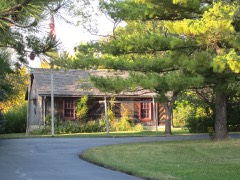 | Jacob Schunk Farmhouse | 6.0 miles | 1983 |
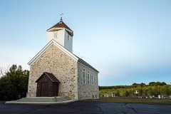 | St. Augustine Catholic Church and Cemetery | 6.8 miles | 1990 |
| National Archives record | The nomination case file for reference 100008864 in Record Group 79. |
| Washington County | All 30 listed properties in this county. |