 Block
From the record
One of 36 National Register listings published here for Grant County · listed in 2023 · category: Building.
Sources: the National Register database, National Park Service
Listed on the National Register of Historic Places in 2023.
One of 36 National Register listings published here for Grant County · listed in 2023 · category: Building.
Sources: the National Register database, National Park Service
An account from the chapter on Platteville city. The inset identifies its exact source book and publication year.
In December following, the small-pox broke out in the village, and, before the physicians were able to agree as to the exact nature of the malady, an epidemic succeeded. It was believed to have been imported hither from Milwaukee by a merchant of Platteville, whose clothing had become impregnated with the seeds of disease while in the former city.
The chapter on Platteville City in History of Grant County, Wisconsin, published 1881 names Platteville. This is what it says, exactly as the scans read.
In November, 1827, John H. Kountree, still a prominent and distinguished resident of the township, accompanied by Maj. J. B. Campbell and two men named William Ruby and John McWilliams, made his advent into future Platteville, attracted thither by the opportunities he had ascertained only awaited the hand of industry and enterprise to pluck without resistance, rhe previous spring it might be interpolated. Mr. Rountree had satisfied himself of these facts and began negotiating for the purchase of a claim owned by one Emanuel Medcalf, who ^covered its value some time before while prospecting for mineral. After several attempts to «ffect its purchase which had failed to culminate, Messrs. Rountree and Campbell accomplished their object, paying for the title $3,600 ; contingently upon its equaling moderate expectations, rt J*' ^^^ period indicated, came into the territory to test its value and identify themselves with the development of this portion of the "lead mines." These adventurous comers knew that, 'fith patient watch and untiring diligence they would reap a generous reward, and having wected a sod cabin twelve feet square on the branch about two hundred yards southeast of Mr. Kountree's present mansion, corner of Pine and Lydia streets, began working the claim as the breath of advancing winter made them to realize that the fall with all its glories had vanished, to be laid in the great storehouse of the past. Through storm and sunshine, when the icy air swept down the valley of the branch chilling all before its way, these four men toiled on from early to late hoping and thinking that, with the dawn of spring, their labors, their enterprise and their patience would be rewarded. So hoped and thought Columbus as he lay at anchor among the drifting seaweed and waited for the dawn of day. Nor was he disappointed, nor were the toilers in the lead discovered by Emanuel Medcalf, doomed to failure. Before the wandering snow flakes, sweet and silent messengers from a sinless region, had ceased to fall and kiss the earth's brown breast with their soft white lips, the toilers had laid up a hundred-fold of the treasure gathered with the " pick and gad." In truth, the results which attended the efforts of this quartette who first came to Platteville Township are said to have been of the most generous character. But there was no furnace nearer than Gratiot's Grove or Galena in which the raw material could be rendered a marketable commodity, and until one was built the mineral was slacked up awaiting its completion.
Passage source: History of Grant County, Wisconsin, published 1881.
In October, 1827, the settlement was called Platte River and continued under that title until April 7,1828, when the name was changed to Lebanon, by which it was known until May 20, of the same year, when Platteville was substituted and still obtains. From records beyond dispute it appears that the following were residents of the vicinage at that date, in addition to those named: A. and W. Daugherty, Samuel Kirkpatrick, A. L. Orden, Alexander Willard, B. B. Lawless, John Wellmaker, Waller Rowen, William Morrison, Joseph Brammer, M. M. Woodbridge, Jesse Harrison, Benjamin James, Frederick Reamer, Isaac Yoakum, Thomas Densen, Israel Mitchell, Robert Roper, James R. Vineyard and William B. Vineyard.
Passage source: History of Grant County, Wisconsin, published 1881.
Machine-read from a century-old scan, so expect the errors a machine makes: misspelled names, dropped words, stray characters.
Read the whole chapter on Platteville City - 148,496 words on its settlement, mills, schools and churches.
Regional context, not property-specific evidence. The federal wildfire occurrence database lists 13 fires within 5 miles of Edward and Mary Davies House between 2018 and 2020, burning about 5 acres in total. None started naturally. None was recorded as arson. Distance is straight-line from the map coordinates, so a fire counted here may appear on a neighbouring settlement's page as well.
| Reported cause | Fires |
|---|---|
| Missing data/not specified/undetermined | 6 |
| Debris and open burning | 4 |
| Equipment and vehicle use | 2 |
| Recreation and ceremony | 1 |
The most recent of them, most recent first, with the day each was reported and the service that recorded it.
| Date | Cause | Size | Reported by | Name on the report |
|---|---|---|---|---|
| 6 August 2020 | Debris and open burning | under an acre | Wisconsin Department of Natural Resources | 20137 |
| 4 July 2020 | Missing data/not specified/undetermined | under an acre | Wisconsin Department of Natural Resources | 20108 |
| 12 June 2020 | Missing data/not specified/undetermined | under an acre | Wisconsin Department of Natural Resources | 20090 |
| 7 April 2018 | Missing data/not specified/undetermined | under an acre | Wisconsin Department of Natural Resources | 2018057 |
| 6 April 2019 | Debris and open burning | under an acre | Wisconsin Department of Natural Resources | 191007 |
| 5 April 2020 | Missing data/not specified/undetermined | under an acre | Wisconsin Department of Natural Resources | 20057 |
| 26 April 2020 | Missing data/not specified/undetermined | under an acre | Wisconsin Department of Natural Resources | 20064 |
| 31 March 2018 | Missing data/not specified/undetermined | under an acre | Wisconsin Department of Natural Resources | 2018054 |
Regional context, not property-specific evidence. The federal mineral resources record lists 102 workings within 5 miles of Edward and Mary Davies House: 54 past producers, 41 unknowns, 4 prospects, 3 producers. 3 still produce. What was taken out: Zinc, Lead, Stone, Lead, Zinc. Distance is straight-line from the map coordinates, so a quarry counted here may appear on a neighbouring settlement's page as well.
| Where | Site | Commodity | Status | Recorded |
|---|---|---|---|---|
| Upper Mississippi Valley Zn - Pb Dist. Mines | Zinc, Lead, Cadmium, Copper, Barium-Barite | Producer | 1750 | |
| Beloit-Elmo | Lead, Zinc | Past Producer | 1908, 1909 | |
| Big Jack | Zinc, Lead | Past Producer | 1926, 1941 | |
| Big Patch Quarry | Stone, Crushed/Broken | Past Producer | ||
| Blockhouse | Zinc, Lead | Past Producer | 1914, 1916 | |
| Cruson | Zinc, Lead | Past Producer | 1908, 1909 | |
| Goke-Blockhouse | Lead, Zinc | Past Producer | 1920, 1921 | |
| Kingeter | Lead, Zinc | Prospect | 1906 | |
| Kistler and Stephens | Lead, Zinc | Past Producer | 1917 | |
| Klar Quarry | Stone, Crushed/Broken | Past Producer |
Regional context, not property-specific evidence. The National Weather Service names Platteville, the town this property stands in, in 60 storm reports between 1997 and 2025: 23 thunderstorm wind, 22 hail, 6 heavy rain, 3 funnel cloud. The reports record 5 injuries. Each account below is quoted exactly as the forecast office filed it, from the NOAA Storm Events Database, and each date opens the federal record of that event.
| When | Event | Place named | Harm | What the report says |
|---|---|---|---|---|
| June 2014 | Tornado (EF2) | Platteville | 5 hurt, $20,500,000 | A tornado formed along a squall line west of Platteville, just south of County Road B, and traveled through Memorial Park on to the Univ. of Wisconsin - Platteville campus. Five people were injured, one of them seriously. There was extensive damage done to five buildings and the stadium on campus. Roofs of two new residential halls were partially destroyed and a third residential hall was also damaged along with one academic building. Two large lighting structures at the football stadium were knocked over, with one crashing across the bleachers causing the concrete foundation underneath the bleachers to be substantially moved. Damage continued into nearby homes and businesses as the tornado tracked across Business Highway 151. The top level of a split level home was ripped off one house, another house lost part of a roof and a porch while several other homes had windows blown out and trees knocked down. A gas station/convenience store was leveled by the tornado where it also ripped a pump out of the ground and blew over a semi. Numerous other business and vehicles suffered blown out windows. After hitting a cemetery on the south side of town, the tornado dissipated just before reaching U.S. Highway 151 southeast of town. A total of 12 homes were destroyed with another 20 damaged.||At UW-Platteville, the tornado caused $7.3 million in damage to Bridgeway Commons, $4.8 million in damage to Rountree Commons and $1.8 million to Southwest Hall. All three buildings are dorms.||The tornado caused $1.8 million in damage to Engineering Hall, a classroom building, and $1.7 million in damage to the stadium. |
| July 2010 | Flood | Platteville | $1,250,000 | The Grant County Emergency Manager reported that U.S. Highway 151 was closed at the SW Road interchange. County Road B was also closed for a while. County Road O sustained substantial damage and was likely closed for around a week. County Road U sustained shoulder damage. Water was also over SW Road near the intersection with Pioneer Road in the southwest part of the city of Platteville. Newspaper articles indicate at least 90 homes throughout the county were damaged by the flooding. Some of the homes had water at least 5 feet above ground level. A two day rainfall total of 9.25 inches was measured at 6 a.m. CST on July 24th in Dickeyville. A three day rainfall total of 8.96 inches in Rockville was measured at 6 a.m. CST July 24th. |
| June 2014 | Tornado (EF1) | Platteville | $540,000 | A second tornado (EF1) hit the northeast corner of Platteville, near the Golf and Country Club. The track was about 1/2 mile long with a 50 yard width. Damage included some trees knocked down and a roof off an apartment building. |
| June 2015 | Thunderstorm Wind | Platteville | $80,000 | Several trees were blown down in Platteville by an estimated 70 mph wind gust. The roof was blown off the dairy barn and another barn had a 100 square foot hole in the roof on the University of Wisconsin-Platteville campus. Several of the downed trees landed on houses and a church. Power was not restored to downtown Platteville until after 5 p.m. |
| June 2015 | Thunderstorm Wind | Platteville | $75,000 | Two dairy farms southeast of Platteville had every building damaged, with four completely destroyed. Animals on the farms were injured as barns and calf hutches were blown apart. |
| July 2009 | Flash Flood | Platteville | $35,000 | High water from swollen creeks was approaching buildings in Platteville. There were significant issues due to high water throughout the city. |
| July 1998 | Thunderstorm Wind | Platteville | $35,000 | no account filed |
| June 2015 | Thunderstorm Wind | Platteville | $25,000 | A tree was blown onto a house west of Platteville creating holes in the roof. |
| July 2008 | Thunderstorm Wind | Platteville | $25,000 | Numerous large trees and power lines were down in the city of Platteville. This caused power outages in parts of the city, along with damage to a home and a garage. |
| October 2019 | Thunderstorm Wind | Platteville | $15,000 | The roof was blown off a farm building near Platteville. |
| July 2009 | Hail | Platteville | $12,000 | There was also a tree blown down on Old Lancaster Road. |
| May 2000 | Hail | Platteville | $12,000 | no account filed |
| July 2023 | Thunderstorm Wind | Platteville | $10,000 | Public reported fallen trees and power outages near Platteville. |
| July 2023 | Hail | Platteville | $10,000 | Trained spotter reported hen egg sized hail near Platteville. |
| August 2020 | Thunderstorm Wind | Platteville | $10,000 | Trees were blown down in Platteville. One tree fell on a house and four roads were blocked by the downed trees. |
| July 2009 | Hail | Platteville | $10,000 | no account filed |
| April 1997 | Thunderstorm Wind | Platteville | $10,000 | no account filed |
| May 2017 | Thunderstorm Wind | Platteville | $5,000 | A semitrailer was tipped over in Platteville. |
| August 2020 | Thunderstorm Wind | Platteville | $4,000 | Trees were damaged and power outages occurred just west of Platteville. |
| July 2009 | Hail | Platteville | $4,000 | In addition to the hail, winds were also 40 mph. |
| August 2021 | Thunderstorm Wind | Platteville | $3,000 | A 60 mph wind gust was measured by the fire department in Platteville. Power lines were blown down by the high winds. |
| July 2009 | Thunderstorm Wind | Platteville | $3,000 | Numerous shredded leaves were noted on trees from earlier wind and hail. Water runoff was high. |
| July 2009 | Hail | Platteville | $3,000 | In addition to the hail, there were wind gusts measured at 50 mph. |
| April 2006 | Hail | Platteville | $3,000 | no account filed |
| June 2013 | Thunderstorm Wind | Platteville | $2,000 | Several trees were blown down in Platteville. |
| July 2012 | Thunderstorm Wind | Platteville | $2,000 | Trees were blown down in Platteville along with the surrounding rural areas. |
| September 2001 | Thunderstorm Wind | Platteville | $1,500 | no account filed |
| June 2024 | Flash Flood | Platteville | $1,000 | The public reported culverts overflowing across Highway 81. |
| April 2006 | Hail | Platteville | $800 | no account filed |
| June 2005 | Thunderstorm Wind | Platteville | $800 | no account filed |
| May 2000 | Thunderstorm Wind | Platteville | $500 | no account filed |
| April 2025 | Hail | Platteville | - | The public reported golf ball sized hail 3 miles west of Platteville. |
| April 2025 | Hail | Platteville | - | The public reported golf ball sized hail in Platteville. The report was relayed via social media. |
| April 2025 | Hail | Platteville | - | The public reported 2 inch diameter hail 1 mile west-northwest of Platteville. The report was relayed via social media. |
| April 2025 | Hail | Platteville | - | The public reported baseball sized hail 3 miles west of Platteville. |
| April 2025 | Hail | Platteville | - | The public reported tennis ball sized hail 1 mile west of Platteville. |
| May 2024 | Hail | Platteville | - | Local media reported ping pong ball sized hail in the city of Platteville. |
| June 2024 | Flash Flood | Platteville | - | Street flooding was reported on Grandview Lane. |
| October 2023 | Heavy Rain | Platteville | - | An automated weather observation station reported 2.24 inches of rainfall near Platteville. |
| December 2021 | Thunderstorm Wind | Platteville | - | The automated weather observing equipment at the Platteville airport measured a 68 mph wind gust. |
| August 2021 | Thunderstorm Wind | Platteville | - | The automated weather observing equipment at the Platteville airport measured a wind gust of 70 mph. |
| June 2019 | Thunderstorm Wind | Platteville | - | The automated weather observing equipment at the Platteville airport measured a gust of 75 mph. |
| October 2019 | Heavy Rain | Platteville | - | The mesonet reporting equipment near Platteville measured 3.53 inches of rain. |
| July 2019 | Heavy Rain | Platteville | - | In Platteville, 3.7 inches of rain fell. |
| June 2018 | Funnel Cloud | Platteville | - | A funnel cloud was sighted in Platteville. |
| July 2017 | Thunderstorm Wind | Platteville | - | A wind gust to 77 mph occurred in Platteville. |
| July 2015 | Funnel Cloud | Platteville | - | A funnel cloud was sighted near Platteville. |
| July 2012 | Thunderstorm Wind | Platteville | - | A wind gust of 60 mph was measured north of Platteville where half inch hail also fell. |
| April 2011 | Hail | Platteville | - | Nickel to quarter size hail fell from just west of Platteville into the city itself. |
| May 2011 | Hail | Platteville | - | no account filed |
| July 2009 | Heavy Rain | Platteville | - | no account filed |
| July 2009 | Heavy Rain | Platteville | - | no account filed |
| July 2009 | Heavy Rain | Platteville | - | no account filed |
| June 2008 | Hail | Platteville | - | no account filed |
| March 2007 | Funnel Cloud | Platteville | - | no account filed |
| June 2003 | Hail | Platteville | - | no account filed |
| April 2002 | Hail | Platteville | - | no account filed |
| April 2002 | Hail | Platteville | - | no account filed |
| April 2002 | Hail | Platteville | - | no account filed |
| May 2000 | Hail | Platteville | - | no account filed |
No historic map-sheet match is published for this property yet. That does not mean no map exists. This record needs a coordinate-quality review before it can be joined to a sheet boundary. Browse the county's mapped places while that work is pending.
Other National Register properties close enough to walk or drive between, ordered by distance from this one. Both positions come from the same geocoding pass that matched these properties to their map sheets.
| Photograph | Property | Distance | Listed |
|---|---|---|---|
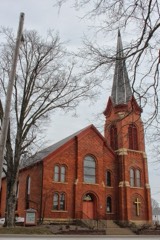 | First Congregational Church | 0.1 miles | 1985 |
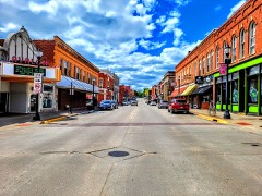 | Main Street Commercial Historic District | 0.2 miles | 1990 |
| Trinity Episcopal Church | 0.2 miles | 2023 | |
| German Evangelical Lutheran Church of Peace | 0.2 miles | 2022 | |
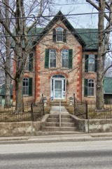 | Beebe House | 0.3 miles | 1979 |
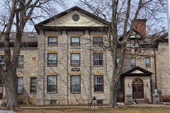 | Rountree Hall | 0.3 miles | 1974 |
| National Archives record | The nomination case file for reference 100009038 in Record Group 79. |
| Grant County | All 36 listed properties in this county. |