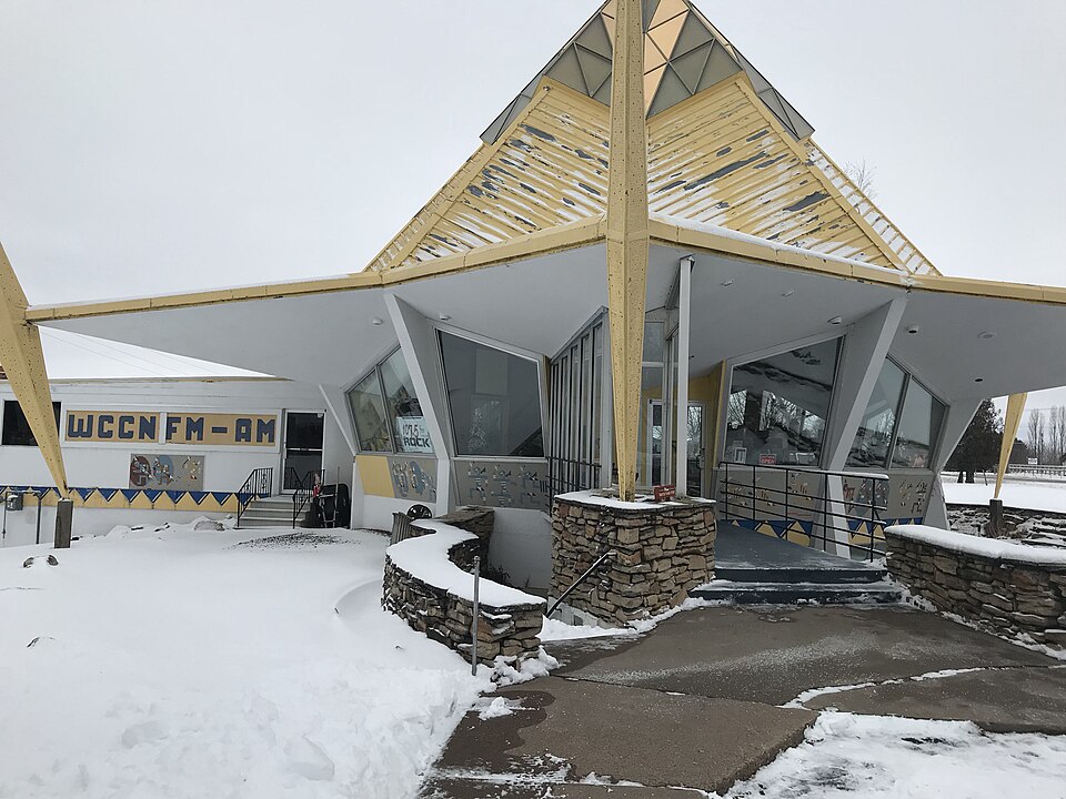
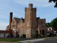
Built in 1964 (mid-century modern). Listed on the National Register of Historic Places in 2012.
From the record
“The Wisconsin Pavilion is a modernist-style building at 1201 East Division Street in Neillsville, Wisconsin, United States. Designed by John Steinmann, it was erected for the 1964 New York World's Fair at Flushing Meadows-Corona Park in Queens, New York, serving as the rotunda for the fair's Wisconsin exhibit.”
Wikipedia article Wisconsin Pavilion, CC BY-SA 4.0.
One of 22 National Register listings published here for Clark County · listed in 2012 · category: Building · built in 1964, mid-century modern.
National Register reference number.12000021- the number the National Park Service assigned this property when it was listed, and the key its nomination file is catalogued under at the National Archives.
Fires near this property
19 since 1992
Regional context, not property-specific
evidence. The
federal wildfire occurrence database
lists 19 fires within 5 miles of Wisconsin Pavilion
between 1992 and 2020, burning about 82 acres in total. None started naturally. 2 were recorded as arson.
Distance is straight-line from the map coordinates, so a fire counted
here may appear on a neighbouring settlement's page as well.
Reported cause
Fires
Debris and open burning
7
Equipment and vehicle use
5
Missing data/not specified/undetermined
3
Recreation and ceremony
2
Arson/incendiarism
2
The most recent of
them, most recent first, with the day each was reported and the service
that recorded it.
Regional context, not property-specific
evidence. The federal mineral resources record lists
3 workings within 5 miles of Wisconsin Pavilion: 1 past producer, 1 unknown, 1 producer.
1 still produces. What was taken out: Sand and Gravel, Construction, Stone, Crushed/Broken. Distance is straight-line from the
map coordinates, so a quarry counted here may appear on a neighbouring
settlement's page as well.
Regional context, not property-specific
evidence. The National Weather Service names
Neillsville, the town this property stands in, in 61 storm reports between 1993 and 2026: 25 thunderstorm wind, 22 hail, 4 funnel cloud, 4 flood.
No death or injury is recorded in these reports. Each account below is quoted exactly as the forecast office
filed it, from the NOAA Storm Events Database, and each date
opens the federal record of that event.
This EF2 tornado developed northeast of Neillsville and moved northeast before dissipating after crossing State Highway 73 just north of Schofield Road. A farm took a direct hit from the tornado where a barn was shifted off its foundation, a truck moved almost 100 feet and roof damage to the house occurred.
O'Neill Creek was flooding in downtown Neillsville. This flooding impacted a few homes and businesses as the water made it to the base of four homes and was just inches from flooding a shopping center.
Thunderstorm winds blew the roof off an out building northeast of Neillsville. In Neillsville, a one foot diameter tree and a telephone pole were blown down along with tree branches in various parts of the city. Power outages lasted several hours.
Runoff from rain and melting snow pushed the Black River out of its banks in Neillsville. The river crested around a half foot above the flood stage at 18.42 feet on April 18th.
Runoff from heavy rain pushed the Black River out of its banks near Neillsville. The river crested around three feet above the flood stage at 21.07 feet.
Locally heavy rains pushed the Black River near Neillsville out of its banks on September 23rd and 24th. The river exceeded the flood stage by almost a foot, cresting at 18.78 feet.
Storm total rainfall was 5.40 inches. On September 23rd a total of 3.80 inches of rain fell setting a record for any daily amount in the month of September.
Thunderstorms producing torrential downpours developed over western and north-central parts of Wisconsin during the early morning on the 14th, again later in the evening and continued into the early morning hours of the 15th. Four day rainfall totals, from the 12th to the 16th, reached in excess of six inches. The highest rainfall reported was 13.10 inches near Phillips (Price County). The runoff from the four days of rain, drained into the Flambeau and Chippewa Rivers. The Flambeau River crested near Bruce (Rusk County) at 12.42 Feet on the morning of the 16th. The Chippewa River at Bruce (Rusk County) crested at 18.12 feet on the evening of the 17th. Flood stage is 12 feet. The Chippewa River crested during the evening of the 17th at Chippewa Falls (Chippewa County) at a level of 17.38 feet and flood stage is 16 feet. Several county highways were flooded across Rusk County, Chippewa County, and Eau Claire County as the rivers rose. A small portion of the University of Wisconsin Campus at Eau Claire was flooded due to the high water along the Chippewa River. On the 14th...minor flooding took place along the Trempealeau River. Several roads, including Highways 93 and 95 near Arcadia and Blair were closed through the 15th. Also, a dike near Arcadia was breached in a couple of places, but did not break. Lowland and agricultural flooding continued downstream at Dodge through the end of the week. In Trempealeau County rainfall totals of four to six inches were common along with isolated amounts of seven to eight inches. Flash flooding occurred on Tappen Coulee Creek near Blair forcing the closure of Highway 95 where two feet of water covered the road. On the 15th...severe thunderstorms uprooting trees and power lines and causing minor property damage occurred over western Wisconsin. In addition heavy rain flooded numerous basements and several roadways over northwest Wisconsin. A small dam on Glen Denning Creek near Danbury (Burnett County) gave way washing out a bridge on Highway 35. Traffic was rerouted for a month.
No historic map-sheet match is published
for this property yet. That does not mean no map exists. This record needs
a coordinate-quality review before it can be joined to a sheet boundary.
Browse the county's mapped places while that work is
pending.
Listed places nearby
6 within 8 miles
Other National Register properties close
enough to walk or drive between, ordered by distance from this one. Both
positions come from the same geocoding pass that matched these properties
to their map sheets.
Listing record. National Park Service National Register of Historic Places, listed-properties dataset, current to 2026-05-22.
Map join. Address geocoded through the United States Census geocoder, then tested against the published boundary of every sheet in the USGS Historical Topographic Map Collection.
How this page is made. Listing fields come from federal records; map-sheet coverage is a labelled coordinate-to-boundary calculation, not a source-field claim.
Wildfire. Short, Karen C. 2022. Spatial wildfire occurrence data for the United States, 1992-2020 [FPA_FOD_20221014]. 6th Edition. Fort Collins, CO: Forest Service Research Data Archive. https://doi.org/10.2737/RDS-2013-0009.6 Collected with United States Government funding and usable without additional permissions or fees.
Mines and quarries. USGS Mineral Resources Data System (MRDS) https://mrdata.usgs.gov/mrds/ A work of the United States government, no copyright under 17 U.S.C. 105.
Storms. NOAA National Centers for Environmental Information, Storm Events Database https://www.ncei.noaa.gov/stormevents/ A work of the United States government, no copyright under 17 U.S.C. 105. Narratives are quoted verbatim from the National Weather Service report and are not edited or summarised.
 Block