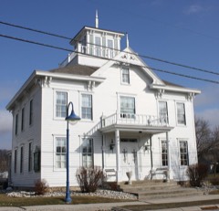
Built in 1918 (Colonial Revival architecture). Listed on the National Register of Historic Places in 2012.
From the record
One of 68 National Register listings published here for Door County · listed in 2012 · category: Building · built in 1918, Colonial Revival architecture.
National Register reference number.12000314- the number the National Park Service assigned this property when it was listed, and the key its nomination file is catalogued under at the National Archives.
Once upon a time a young Chippewa Indian from Washington Island was hunting with his dog on the hill overlooking Horseshoe Bay in the present Town of Egg Harbor. As he was cautiously stepping forward amid the tall trees and occasional open glades he spied two bear cubs comfortably dozing on the sunny side of a big windfall. Being, like all Indians, fond of pets, he silenced and restrained his eager dog and crept forward intending to capture the cubs alive. When near them he laid down his gun and suddenly pouncing upon them he seized them both. Immediately there was much squirming and yelping but he managed to get a good hold in the fur of the neck and after a brief struggle arose with one cub in each hand. No sooner was he on his feet, however, before he heard a ferocious growl behind him. Turning instantly he saw a huge bear, the mother of the captive cubs, advancing upright on her hind feet. His gun was on the ground some distance away, so dropping the cubs he pulled his tomahawk and his knife to defend himself. He had only time, however, to raise his arm to throw the tomahawk when the savage beast was upon him and giving his arm a tremendous blow which broke it like a pipe stem she sent his tomahawk flying through the air several rods away. Then she seized him in a terrible embrace and he felt his ribs cracking.
Egg Harbor seems to have been a great place for bears. Old settlers tell of them invading their storehouses to steal their bacon and drink their milk. Once in broad daylight it even happened that a child was carried away by a bear. This happened at the home of Fred Kracht in section 32. It was on a morning in May, 1876. The father had gone to Baileys Harbor. The mother, eager for a piece of gossip, had left her little two year old boy undressed in the yard while she strolled down to a neighbor woman some distance away for a chat. Soon the dog which was chained was heard savagely barking and the child screaming in terror. The mother and the neighbors hurried to the house but the child was nowhere to be found. A general alarm was sounded and scores of men turned out to search the woods and the fields thoroughly. Nothing was ever found of the child, however, only some big fresh bear tracks leading into the swamp.
Regional context, not property-specific
evidence. The
federal wildfire occurrence database
lists 9 fires within 5 miles of Murphy Farms Number 1
between 2018 and 2020, burning about 5 acres in total. None started naturally. None was recorded as arson.
Distance is straight-line from the map coordinates, so a fire counted
here may appear on a neighbouring settlement's page as well.
Reported cause
Fires
Missing data/not specified/undetermined
5
Debris and open burning
4
The most recent of
them, most recent first, with the day each was reported and the service
that recorded it.
Regional context, not property-specific
evidence. The federal mineral resources record lists
1 working within 5 miles of Murphy Farms Number 1: 1 past producer.
None of them still produces. What was taken out: Stone, Crushed/Broken. Distance is straight-line from the
map coordinates, so a quarry counted here may appear on a neighbouring
settlement's page as well.
Regional context, not property-specific
evidence. The National Weather Service names
Egg Harbor, the town this property stands in, in 28 storm reports between 1996 and 2025: 16 thunderstorm wind, 10 hail, 1 tornado, 1 waterspout.
The reports record 2 injuries. Each account below is quoted exactly as the forecast office
filed it, from the NOAA Storm Events Database, and each date
opens the federal record of that event.
Thunderstorm winds downed trees and power lines on highway 42 from Egg Harbor to Fish Creek, making the road impassable. The time of this report is an estimate based on radar data.
Thunderstorm winds downed trees and power lines in Egg Harbor. There were also sporadic reports of trees and power lines down throughout Door County. The time of this report was estimated based on radar data.
No historic map-sheet match is published
for this property yet. That does not mean no map exists. This record needs
a coordinate-quality review before it can be joined to a sheet boundary.
Browse the county's mapped places while that work is
pending.
Listed places nearby
4 within 8 miles
Other National Register properties close
enough to walk or drive between, ordered by distance from this one. Both
positions come from the same geocoding pass that matched these properties
to their map sheets.
Listing record. National Park Service National Register of Historic Places, listed-properties dataset, current to 2026-05-22.
Map join. Address geocoded through the United States Census geocoder, then tested against the published boundary of every sheet in the USGS Historical Topographic Map Collection.
How this page is made. Listing fields come from federal records; map-sheet coverage is a labelled coordinate-to-boundary calculation, not a source-field claim.
Wildfire. Short, Karen C. 2022. Spatial wildfire occurrence data for the United States, 1992-2020 [FPA_FOD_20221014]. 6th Edition. Fort Collins, CO: Forest Service Research Data Archive. https://doi.org/10.2737/RDS-2013-0009.6 Collected with United States Government funding and usable without additional permissions or fees.
Mines and quarries. USGS Mineral Resources Data System (MRDS) https://mrdata.usgs.gov/mrds/ A work of the United States government, no copyright under 17 U.S.C. 105.
Storms. NOAA National Centers for Environmental Information, Storm Events Database https://www.ncei.noaa.gov/stormevents/ A work of the United States government, no copyright under 17 U.S.C. 105. Narratives are quoted verbatim from the National Weather Service report and are not edited or summarised.
 Block