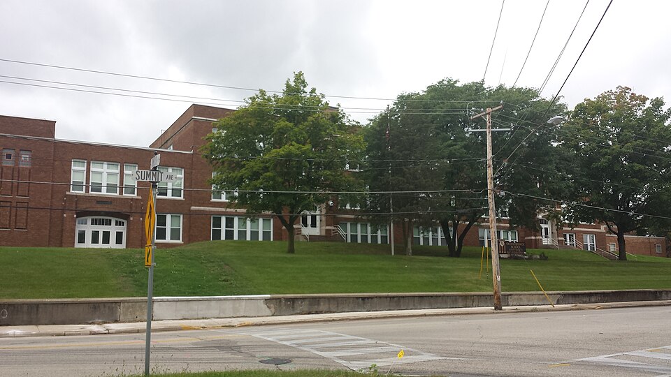
Listed on the National Register of Historic Places in 2013.
From the record
“Mention of the drives in the surrounding country has been made in several instances, but too much cannot be said in their favor, and it is no exaggeration to state that they compare favorably with the choicest drives of which the largest cities boast. In all these drives the visitor will fail to find a single poor team, Oconomowoc particularly boasting of a very superior class of livery.”
The History of Waukesha County, Wisconsin. Containing an Account of Its Settlement, Growth, Development and Resources; an Extensive and Minute Sketch of Its Cities, Towns and Villages--their Improvements, Industries, Manufactories, Churches, Schools and Societies; Its War Record, Biographical Sketches, Portraits of Prominent Men and Early Settlers; the Whole Preceded by a History of Wisconsin, Statistics of the State, and an Abstract of Its Laws and Constitution and of the Constitution of the United States (1880). Machine-read text.
One of 153 National Register listings published here for Waukesha County · listed in 2013 · category: Building.
Lac La Belle is one of the largest and finest lakes at Oconomowoc. It is connected with Fowler's Lake, the most prominent feature on whose pretty shores is the grand, well-known Townsend House. All the hotels at Oconomowoc - there are quite a number, and they are all good - are located on the banks of one or the other of the lakes, and are provided with bathhouses. In addition, there are a number of first-class boarding-houses, and furnishing in all accommodations for about one thousand visitors. A beautiful drive leads to Okauchee Lake, another sheet o? water, which would be prized by the quart in many localities, although it covers sixteen hundred acres. There is much to admire in the scenery at this lake, and soon you will doubtless find a number of commodious and excellent hotels on its shores to meet the wants of tourists who come here for the excellent bass and muskallunge fishing. Numerous private residences are already erected and many more projected. This fact speaks better for this wonderful lake region of Wisconsin than volumes of argument, since expensive houses, to be used during a few months of the year only, are never built except in highly favored localities.
A drive south from Oconomowoc to Dousman's artificial trout pond, some eight miles distant, reached via the ancient mounds. Silver, Otis, Duck and Genesee Lakes and several smaller ones, through a most picturesque country, will prove of special interest to every lover of the rod and line, and not less to the lover of well-prepared trout, visitors catching their own fish, which are prepared for them at the farm at moderate charge.
Regional context, not property-specific
evidence. The
federal wildfire occurrence database
lists 18 fires within 5 miles of Oconomowoc High School
between 2018 and 2020, burning about 11 acres in total. None started naturally. 2 were recorded as arson.
Distance is straight-line from the map coordinates, so a fire counted
here may appear on a neighbouring settlement's page as well.
Reported cause
Fires
Debris and open burning
7
Missing data/not specified/undetermined
7
Arson/incendiarism
2
Smoking
1
Recreation and ceremony
1
The most recent of
them, most recent first, with the day each was reported and the service
that recorded it.
Regional context, not property-specific
evidence. The federal mineral resources record lists
4 workings within 5 miles of Oconomowoc High School: 2 past producers, 2 producers.
2 still produce. What was taken out: Sand and Gravel, Construction. Distance is straight-line from the
map coordinates, so a quarry counted here may appear on a neighbouring
settlement's page as well.
Regional context, not property-specific
evidence. The National Weather Service names
Oconomowoc, the town this property stands in, in 51 storm reports between 1993 and 2025: 22 hail, 21 thunderstorm wind, 6 lightning, 2 flash flood.
No death or injury is recorded in these reports. Each account below is quoted exactly as the forecast office
filed it, from the NOAA Storm Events Database, and each date
opens the federal record of that event.
Numerous reports of a number of large trees snapped and uprooted trees across Waukesha County. Winds were estimated to be upward of 60 mph, with locally higher gusts across the southern portion of the county. Wind measurements near Eagle, WI of 68 to 77 mph were observed. A large tree fell on a house causing significant damage near Eagle, WI. A business marquee sign was knocked over in Waukesha. Hail of three-quarters of an inch was also observed.
Law enforcement officials reported numerous trees and power lines downed by thunderstorm wind gusts, measured by a trained spotter at 68 mph (59 knots). The damage was reported along an 8-mile wide swath from 1.5 miles west of Oconomowoc to 1 mile east of Elm Grove.
Heavy rains resulted in flash flooding as water reached depths of 3 feet or more and several cars stalled. This was one of 3 flash floods in Waukesha County on June 7th. Some crop damage was noted in nearby rural areas around Pewaukee. Another round of heavy rains on June 8th resulted in flash flooding around North Prairie. Collectively, each of these 4 flash floods resulted in home and business damage along with some crop losses. It was nearly impossible to break down the damages by flash flood. Therefore, the collective breakdown is provided in the June 8th StormData entry for Waukesha County.
A storm system brought a variety of weather to far northwest and southeast Wisconsin. In the far north, 6 to 12 inches of snow fell causing accidents, closing schools, and halting city and county government operations. Snow totals included 12 inches at Ashland, Ashland County, 11 inches at Washburn, Bayfield County, and 9.5 inches at Port Wing, Bayfield County. In southeast Wisconsin, isolated severe thunderstorms dropped hail up to the size of golfballs over Jefferson and Waukesha Counties.
No historic map-sheet match is published
for this property yet. That does not mean no map exists. This record needs
a coordinate-quality review before it can be joined to a sheet boundary.
Browse the county's mapped places while that work is
pending.
Listed places nearby
6 within 8 miles
Other National Register properties close
enough to walk or drive between, ordered by distance from this one. Both
positions come from the same geocoding pass that matched these properties
to their map sheets.
Listing record. National Park Service National Register of Historic Places, listed-properties dataset, current to 2026-05-22.
Map join. Address geocoded through the United States Census geocoder, then tested against the published boundary of every sheet in the USGS Historical Topographic Map Collection.
How this page is made. Listing fields come from federal records; map-sheet coverage is a labelled coordinate-to-boundary calculation, not a source-field claim.
Wildfire. Short, Karen C. 2022. Spatial wildfire occurrence data for the United States, 1992-2020 [FPA_FOD_20221014]. 6th Edition. Fort Collins, CO: Forest Service Research Data Archive. https://doi.org/10.2737/RDS-2013-0009.6 Collected with United States Government funding and usable without additional permissions or fees.
Mines and quarries. USGS Mineral Resources Data System (MRDS) https://mrdata.usgs.gov/mrds/ A work of the United States government, no copyright under 17 U.S.C. 105.
Storms. NOAA National Centers for Environmental Information, Storm Events Database https://www.ncei.noaa.gov/stormevents/ A work of the United States government, no copyright under 17 U.S.C. 105. Narratives are quoted verbatim from the National Weather Service report and are not edited or summarised.
 Block