 Block
From the record
One of 22 National Register listings published here for Clark County · listed in 2013 · category: Building.
Sources: the National Register database, National Park Service · the Wikipedia article
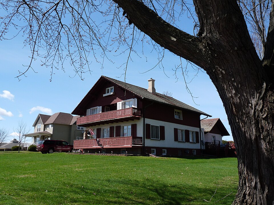
Listed on the National Register of Historic Places in 2013.
One of 22 National Register listings published here for Clark County · listed in 2013 · category: Building.
Sources: the National Register database, National Park Service · the Wikipedia article
Regional context, not property-specific evidence. The National Weather Service names Neillsville, the town this property stands in, in 61 storm reports between 1993 and 2026: 25 thunderstorm wind, 22 hail, 4 funnel cloud, 4 flood. No death or injury is recorded in these reports. Each account below is quoted exactly as the forecast office filed it, from the NOAA Storm Events Database, and each date opens the federal record of that event.
| When | Event | Place named | Harm | What the report says |
|---|---|---|---|---|
| December 2021 | Tornado (EF2) | Neillsville | $200,000 | This EF2 tornado developed northeast of Neillsville and moved northeast before dissipating after crossing State Highway 73 just north of Schofield Road. A farm took a direct hit from the tornado where a barn was shifted off its foundation, a truck moved almost 100 feet and roof damage to the house occurred. |
| May 1996 | Lightning | Neillsville | $80,000 | no account filed |
| September 2010 | Flood | Neillsville | $50,000 | O'Neill Creek was flooding in downtown Neillsville. This flooding impacted a few homes and businesses as the water made it to the base of four homes and was just inches from flooding a shopping center. |
| May 1993 | Thunderstorm Wind | Neillsville | $50,000 | no account filed |
| December 2021 | Thunderstorm Wind | Neillsville | $30,000 | Power lines and trees were blown down across Neillsville. The winds also scattered debris from damaged roofs. |
| May 1998 | Hail | Neillsville | $18,000 | no account filed |
| April 2009 | Hail | Neillsville | $15,000 | Parents of a NWS employee reported large hail at their home. |
| August 1996 | Thunderstorm Wind | Neillsville | $15,000 | no account filed |
| July 2021 | Thunderstorm Wind | Neillsville | $10,000 | Power lines and poles were blown down around Neillsville with almost 400 customers reported to be without power. |
| April 2020 | Thunderstorm Wind | Neillsville | $5,000 | Some trees and power lines were blown down in the Neillsville area. |
| July 2019 | Thunderstorm Wind | Neillsville | $5,000 | A semi-truck was blown off U.S. Highway 10 near Neillsville. |
| August 2012 | Thunderstorm Wind | Neillsville | $5,000 | Power lines and trees were blown down in Neillsville. |
| June 2016 | Thunderstorm Wind | Neillsville | $4,000 | Power poles and trees were blown down in Neillsville. |
| May 2010 | Thunderstorm Wind | Neillsville | $3,000 | Thunderstorm winds blew the roof off an out building northeast of Neillsville. In Neillsville, a one foot diameter tree and a telephone pole were blown down along with tree branches in various parts of the city. Power outages lasted several hours. |
| July 1999 | Thunderstorm Wind | Neillsville | $2,500 | no account filed |
| May 2021 | Thunderstorm Wind | Neillsville | $2,000 | Trees were damaged by strong winds in and near Neilsville. |
| May 2010 | Thunderstorm Wind | Neillsville | $2,000 | A billboard sign was broke in half by severe thunderstorm winds. |
| July 2005 | Thunderstorm Wind | Neillsville | $2,000 | no account filed |
| June 2020 | Thunderstorm Wind | Neillsville | $1,000 | Large tree branches were blown down in Neillsville. |
| June 2007 | Thunderstorm Wind | Neillsville | $1,000 | no account filed |
| June 2005 | Hail | Neillsville | $1,000 | no account filed |
| June 2004 | Thunderstorm Wind | Neillsville | $800 | no account filed |
| September 2007 | Thunderstorm Wind | Neillsville | $500 | Trees were blown down. |
| August 2005 | Thunderstorm Wind | Neillsville | $300 | no account filed |
| July 2000 | Thunderstorm Wind | Neillsville | $250 | no account filed |
| June 2018 | Thunderstorm Wind | Neillsville | $200 | An estimated 60 mph wind gust occurred near Neillsville. The wind gust blew down a tree branch and moved a parked ATV. |
| April 2026 | Hail | Neillsville | - | Law enforcement reported quarter sized hail 1 mile southeast of Neillsville. |
| May 2024 | Hail | Neillsville | - | The public reported nickel sized hail in Neillsville. |
| October 2023 | Hail | Neillsville | - | Broadcast media reported ping pong sized hail in Neillsville. |
| June 2023 | Funnel Cloud | Neillsville | - | A funnel cloud was reported near Neillsville. |
| April 2019 | Flood | Neillsville | - | Runoff from rain and melting snow pushed the Black River out of its banks in Neillsville. The river crested around a half foot above the flood stage at 18.42 feet on April 18th. |
| March 2016 | Heavy Rain | Neillsville | - | A total of 2.07 inches of rain fell near Neillsville. |
| September 2016 | Flood | Neillsville | - | Runoff from heavy rain pushed the Black River out of its banks near Neillsville. The river crested around three feet above the flood stage at 21.07 feet. |
| May 2014 | Heavy Rain | Neillsville | - | Near Neillsville, 2.25 inches of rain fell. |
| August 2014 | Heavy Rain | Neillsville | - | In Neillsville, 2.35 inches of rain was measured. |
| August 2011 | Hail | Neillsville | - | Half dollar sized hail fell in Neillsville. |
| September 2010 | Flood | Neillsville | - | Locally heavy rains pushed the Black River near Neillsville out of its banks on September 23rd and 24th. The river exceeded the flood stage by almost a foot, cresting at 18.78 feet. |
| September 2010 | Heavy Rain | Neillsville | - | Storm total rainfall was 5.40 inches. On September 23rd a total of 3.80 inches of rain fell setting a record for any daily amount in the month of September. |
| September 1994 | Thunderstorm Wind | Neillsville | - | Thunderstorms producing torrential downpours developed over western and north-central parts of Wisconsin during the early morning on the 14th, again later in the evening and continued into the early morning hours of the 15th. Four day rainfall totals, from the 12th to the 16th, reached in excess of six inches. The highest rainfall reported was 13.10 inches near Phillips (Price County). The runoff from the four days of rain, drained into the Flambeau and Chippewa Rivers. The Flambeau River crested near Bruce (Rusk County) at 12.42 Feet on the morning of the 16th. The Chippewa River at Bruce (Rusk County) crested at 18.12 feet on the evening of the 17th. Flood stage is 12 feet. The Chippewa River crested during the evening of the 17th at Chippewa Falls (Chippewa County) at a level of 17.38 feet and flood stage is 16 feet. Several county highways were flooded across Rusk County, Chippewa County, and Eau Claire County as the rivers rose. A small portion of the University of Wisconsin Campus at Eau Claire was flooded due to the high water along the Chippewa River. On the 14th...minor flooding took place along the Trempealeau River. Several roads, including Highways 93 and 95 near Arcadia and Blair were closed through the 15th. Also, a dike near Arcadia was breached in a couple of places, but did not break. Lowland and agricultural flooding continued downstream at Dodge through the end of the week. In Trempealeau County rainfall totals of four to six inches were common along with isolated amounts of seven to eight inches. Flash flooding occurred on Tappen Coulee Creek near Blair forcing the closure of Highway 95 where two feet of water covered the road. On the 15th...severe thunderstorms uprooting trees and power lines and causing minor property damage occurred over western Wisconsin. In addition heavy rain flooded numerous basements and several roadways over northwest Wisconsin. A small dam on Glen Denning Creek near Danbury (Burnett County) gave way washing out a bridge on Highway 35. Traffic was rerouted for a month. |
| April 2017 | Hail | Neillsville | - | no account filed |
| August 2014 | Hail | Neillsville | - | no account filed |
| August 2014 | Hail | Neillsville | - | no account filed |
| May 2011 | Hail | Neillsville | - | no account filed |
| April 2009 | Hail | Neillsville | - | no account filed |
| April 2009 | Hail | Neillsville | - | no account filed |
| August 2006 | Hail | Neillsville | - | no account filed |
| June 2005 | Funnel Cloud | Neillsville | - | no account filed |
| April 2004 | Hail | Neillsville | - | no account filed |
| April 2004 | Thunderstorm Wind | Neillsville | - | no account filed |
| June 2004 | Thunderstorm Wind | Neillsville | - | no account filed |
| June 2004 | Hail | Neillsville | - | no account filed |
| June 2004 | Hail | Neillsville | - | no account filed |
| April 2002 | Hail | Neillsville | - | no account filed |
| April 2002 | Hail | Neillsville | - | no account filed |
| September 2002 | Thunderstorm Wind | Neillsville | - | no account filed |
| June 2001 | Hail | Neillsville | - | no account filed |
| July 1999 | Funnel Cloud | Neillsville | - | no account filed |
| July 1999 | Funnel Cloud | Neillsville | - | no account filed |
| May 1998 | Hail | Neillsville | - | no account filed |
| June 1997 | Hail | Neillsville | - | no account filed |
No historic map-sheet match is published for this property yet. That does not mean no map exists. This record needs a coordinate-quality review before it can be joined to a sheet boundary. Browse the county's mapped places while that work is pending.
| National Archives record | The nomination case file for reference 13000651 in Record Group 79. |
| Wikipedia article | Community-written account of this property, licensed CC BY-SA. |
| Clark County | All 22 listed properties in this county. |