National Register reference number. 16000240 - assigned by the National Park Service when the property was listed.
The ground it stands on
1,587 words
The chapter on Owen City in History of Clark County Wisconsin, published 1918 names Owen. This is what it says, exactly as the scans read.
Owen is one of the newer villages in Clark County, but is one of the most thriving, and as the center of extensive logging operations being carried on in the counties to the north has wonderful possibilities of future development and prosperity. It is an important railroad junction point, as the Fairchild & Northeastern has its terminal here, and the "Soo" line extends in four different directions, Three or four hundred square miles of the richest farming country are tributary to the village, and it is noted as a shipping point for stock and farm produce, as well as for its lumbering interests.
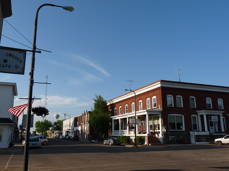
There has been a steady and conservative growth, the demand for houses always exceeding the supply, although the company and private individuals have kept busy building ever since the town was started. The village has an electric light plant (operated by the J. S. Owen Lumber Company) and water works and a sewer system. Besides the sawmill and box factory, which employ about 300 men, there is a large pea canning factory, with a capacity of 30,000 cases, a potato warehouse and elevator and teed mill, four hotels, four general stores, a bakery, butcher shop, tailor shop, jewelry store, two hardware stores, three barber shops, a shoe store and harness shop, one moving picture theatre, a bottling works, a thriving bank and a newspaper, besides several saloons, and a local telephone. The Woodland Hotel, owned by the Owen Company, is probably one of the best hotels in Wisconsin for a town the size of Owen, being built of stone and brick, with twenty-four transient rooms and all modern equipment. A Commercial Club, officered by some of the leading citizens, is active in advancing the general interests of the community.
Regional context, not property-specific
evidence. The
federal wildfire occurrence database
lists 4 fires within 5 miles of Woodland Hotel
between 2010 and 2020, burning about 16 acres in total. None started naturally. None was recorded as arson.
Distance is straight-line from the map coordinates, so a fire counted
here may appear on a neighbouring settlement's page as well.
Reported cause
Fires
Missing data/not specified/undetermined
3
Equipment and vehicle use
1
The most recent of
them, most recent first, with the day each was reported and the service
that recorded it.
Regional context, not property-specific
evidence. The federal mineral resources record lists
1 working within 5 miles of Woodland Hotel: 1 past producer.
None of them still produces. What was taken out: Sand and Gravel, Construction. Distance is straight-line from the
map coordinates, so a quarry counted here may appear on a neighbouring
settlement's page as well.
Regional context, not property-specific
evidence. The National Weather Service names
Owen, the town this property stands in, in 31 storm reports between 1995 and 2023: 15 thunderstorm wind, 13 hail, 2 heavy rain, 1 funnel cloud.
No death or injury is recorded in these reports. Each account below is quoted exactly as the forecast office
filed it, from the NOAA Storm Events Database, and each date
opens the federal record of that event.
Trees and power lines were blown down in and near Owen. One tree landed on a house and over 1,100 customers were without power after the storms moved through.
No historic map-sheet match is published
for this property yet. That does not mean no map exists. This record needs
a coordinate-quality review before it can be joined to a sheet boundary.
Browse the county's mapped places while that work is
pending.
Listed places nearby
1 within 8 miles
Other National Register properties close
enough to walk or drive between, ordered by distance from this one. Both
positions come from the same geocoding pass that matched these properties
to their map sheets.
Listing record. National Park Service National Register of Historic Places, listed-properties dataset, current to 2026-05-22.
Map join. Address geocoded through the United States Census geocoder, then tested against the published boundary of every sheet in the USGS Historical Topographic Map Collection.
How this page is made. Listing fields come from federal records; map-sheet coverage is a labelled coordinate-to-boundary calculation, not a source-field claim.
Wildfire. Short, Karen C. 2022. Spatial wildfire occurrence data for the United States, 1992-2020 [FPA_FOD_20221014]. 6th Edition. Fort Collins, CO: Forest Service Research Data Archive. https://doi.org/10.2737/RDS-2013-0009.6 Collected with United States Government funding and usable without additional permissions or fees.
Mines and quarries. USGS Mineral Resources Data System (MRDS) https://mrdata.usgs.gov/mrds/ A work of the United States government, no copyright under 17 U.S.C. 105.
Storms. NOAA National Centers for Environmental Information, Storm Events Database https://www.ncei.noaa.gov/stormevents/ A work of the United States government, no copyright under 17 U.S.C. 105. Narratives are quoted verbatim from the National Weather Service report and are not edited or summarised.
 Block