BlockBefore
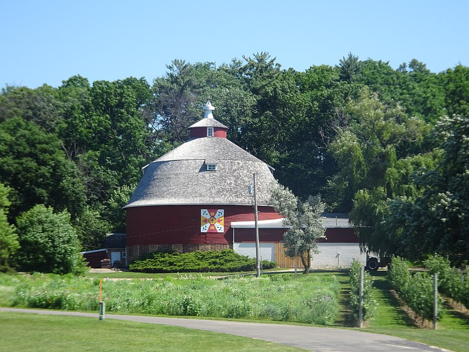
Photograph of Albert and Minna Ten Eyck Round Barn
Photograph by Corey Coyle ( Archive link ), CC BY 3.0. Via Wikimedia Commons.

Albert and Minna Ten Eyck Round Barn

Built in 1922. Listed on the National Register of Historic Places in 2016.

From the record

“The Albert and Minna Ten Eyck Round Barn is located in Spring Grove, Wisconsin.”

Wikipedia article Albert and Minna Ten Eyck Round Barn, CC BY-SA 4.0.

One of 31 National Register listings published here for Green County · listed in 2016 · category: Building · built in 1922.

Sources: the Wikipedia article · the National Register database, National Park Service
The listing

  • What is counted as historic. The nomination lists 1 building as contributing to the listing.
  • Still standing. The Park Service records this property as extant.
  • Listed as. Ten Eyck, Albert and Minna, Round Barn - the National Register files a house under its owner's surname.
  • Address. W968 WI 11, Spring Grove, 53520
  • When was it listed? November 2016
  • Category. building
  • Also known as. Wisconsin Centric Barns MPS; Wisconsin Centric Barns MPS
  • Town. Spring Grove town
  • When was it built? 1922
  • National Register reference number. 16000813 - assigned by the National Park Service when the property was listed.

The ground it stands on

28,363 words

The chapter on Spring Grove Town in History of Green County, Wisconsin, published 1877 names Spring Grove. This is what it says, exactly as the scans read.

Great Britain. At the close of the revolution it was claimed by Virginia, and ceded by that state to the United States, after which it was under the territorial government of Ohio until 1800. From that time until 1809 it was a part of Indiana territory. It was then Included in Illinois territory until 181S, when it was attached to Michigan territory. On the 4th of July, 1S36, it was organized as the territory of Wisconsin. When Michigan territory extended as far west as the Mississippi, that part of the territory lying between Lake Michigan and the Mississippi was divided into two counties, Brown and Crawford. The division was such that that part of Green County which is comprised in fthe four towns, Brooklyn, Albany, Decatur, and Spring Grove, was in Brown County, whose county seat was Green Bay, while the remainder was in Crawford County, of which Prairie du Chien was the county seat. So far as this county is concerned, the memory of man goeth back only to 1826-7. In 1826 there began to be a -great deal of talk about the lead mines of south-western Wisconsin. In 1827 the interest in them was as general .as the interest in the California gold mines in '49, and there was such a rush to them from all parts of the country that sometimes the boats that came up the Mississippi from St. Louis could not carry half of those who wanted to come. Probably the first white men who saw what is now Green County passed this way in 1S26, on their way to the mines near the river. The first who remained came in '28, to trade with the Indians. Their names were McNut and Boner. They stopped at the old Indian, or Sugar River diggings, near the present village of Exeter, where they were soon joined by an interpreter named Van Sickles, and by miners. Some time prior to 1S29, John B. Skinner and Thomas Neal began to work at the Skinner diggings, in the township since called Monroe. In 1S30 Andrew Clarno built the first house in Clarno township, and two years later William Wallace and Joseph Paine, who had been working at the mines, settled near him. New miners came occasionally, but the number of settlers did not increase until after the Black Hawk war, which broke out in the spring of 1S32. Although this war lasted only three months, it must not, on that account, be passed by as unimportant. It cost about three hundred lives, whites and Indians, and even the great rebellion was not a greater source of anxiety, in its time, than was the Black Hawk war to the early settlers. Prior to the war, in October, 1S29, the southern part of Crawford County, including, of course, the greater part of the future county of Green, was organized as Iowa County, of which Mineral Point was the county seat. Most of the depredations of the Indians during the war were committed in the mining districts of Iowa County. Hundreds of miners left the country and never returned. The movements of the Indians were so stealthy and so rapid that the settlers, separated by long distances from each other, were in the wildest alarm. Their thoughts when awake, their dreams when asleep, were all of the Indians. Finally they sought

Passage source: History of Green County, Wisconsin, published 1877.

Among the pioneers of Green County were many single men, some of whom could hardly be called settlers. "My home was under my hat," said one who may be taken as a representative of the class. Yet they did good work in taming the wilderness, and, whether they went from to town and from county to county, as work and the hope of gain called them, or kept bachelor's hall on their own land, they were an important element in the society of that time. Bachelors' parties were among the most enjoyable gatherings there were. Not infrequently, a dozen bachelors met in the evening at Smith & Enos' mill, or at some brother's cabin, and spent the night in fun and jollity. Occasionally, they went as far as Hamilton's diggings to hear the Colonel tell, in his entertaining way, of the great men he had seen at Washington; and sometimes they had a party to which married men and their wives were invited. At one such party at Mr. Rust's, the floor was turned bottom side up after supper, "so as to have a clean, smooth surface " on which to exercise the light fantastic toe. Among the pleasantest parties of this kind in the eastern part of the county, was that given by Mr. Lake to chard, which was one of the first orchards in the county. Mr. Rust's blackberry preserves are still sweet in memory, and those who have forgotten the flavor of Mr. Lake's apples still praise the hot biscuit he made for supper. But if these bachelors cooked well, they did not always cook willingly. One acknowledges that he often went hungry because he had no time to cook. Mr. Asa Richardson used to carry his cream over to Mrs. Rust, preferring to do without butter rather than churn. Another, who proposed to a girl the evening he was introduced and married her the next time they met, explains his haste by saving, " it was the way then to do things up pretty quick, and as I had to work out doors as much as any of the men, nobody needed a wife more than I did." The arrival of a young lady anywhere within fifteen miles was an especial promoter of the labors of hair cutting, shaving, washing, ironing, patching, and darning among the bachelors. There were no photographers to catch the shadow of these self-made men, but an indication of the beauty and harmony to which they were expected to attain in their dress is given by a bit of the exjDerience of a gentleman who in 1S42 went with two companions from Monroe to see a newlv arrived belle of Spring Grove. Despite much preparation, there were still three or four holes in his coat. His companions, who, like himself, are now well known all over the county, told him they could not induce him in such a plight, and, under pretense of pinning up the holes, they managed to grasp the coat fenced, and cultivated ten acres which he s year to Daniel Baxter of New York, who immediate went there to live. The next settle] was Mr. Eli Kline from Indiana. In '37, he and bis sc as, John and Isaac, built a carding mill where the village : Spi Grove, of which it was . eginning, - now. For many years after this, the stream on v c was ailt, name of Si - allj The next year bi Davis of Pennsylvania, who says it cost m move his family and household goods from G 1 : . Spring G - rom Penns at Galena,

Passage source: History of Green County, Wisconsin, published 1877.

Machine-read from a century-old scan, so expect the errors a machine makes: misspelled names, dropped words, stray characters.

Read the whole chapter on Spring Grove Town - 28,363 words on its settlement, mills, schools and churches.

Fires near this property

12 since 2006

Regional context, not property-specific evidence. The federal wildfire occurrence database lists 12 fires within 5 miles of Albert and Minna Ten Eyck Round Barn between 2006 and 2019, burning about 7 acres in total. None started naturally. 1 was recorded as arson. Distance is straight-line from the map coordinates, so a fire counted here may appear on a neighbouring settlement's page as well.

Reported cause Fires
Smoking4
Debris and open burning4
Arson/incendiarism1
Missing data/not specified/undetermined1
Equipment and vehicle use1
Power generation/transmission/distribution1

The most recent of them, most recent first, with the day each was reported and the service that recorded it.

DateCause SizeReported by Name on the report
11 July 2018Equipment and vehicle use2.0 acresWisconsin Department of Natural Resources18067
20 June 2018Power generation/transmission/distribution1.0 acresWisconsin Department of Natural Resources105
3 April 2019Smokingunder an acreWisconsin Department of Natural Resources19030
23 April 2018Smokingunder an acreWisconsin Department of Natural Resources74
22 April 2018Debris and open burningunder an acreWisconsin Department of Natural Resources72
15 April 2019Debris and open burningunder an acreWisconsin Department of Natural Resources19034
11 April 2006Arson/incendiarism1.2 acresWisconsin Department of Natural Resourcesnot named
30 March 2019Debris and open burning2.0 acresWisconsin Department of Natural Resources72

Every fire recorded in Green County

Mines and quarries near this property

2 within 5 miles

Regional context, not property-specific evidence. The federal mineral resources record lists 2 workings within 5 miles of Albert and Minna Ten Eyck Round Barn: 1 past producer, 1 unknown. None of them still produces. What was taken out: Stone, Crushed/Broken, Stone. Distance is straight-line from the map coordinates, so a quarry counted here may appear on a neighbouring settlement's page as well.

Where SiteCommodity StatusRecorded
Coles QuarryStoneUnknown
State Right of Way QuarryStone, Crushed/BrokenPast Producer

Every working recorded in Green County

Map coverage status

No historic map-sheet match is published for this property yet. That does not mean no map exists. This record needs a coordinate-quality review before it can be joined to a sheet boundary. Browse the county's mapped places while that work is pending.

Listed places nearby

2 within 8 miles

Other National Register properties close enough to walk or drive between, ordered by distance from this one. Both positions come from the same geocoding pass that matched these properties to their map sheets.

Photograph PropertyDistance Listed
Exchange Square Historic District2.7 miles1984
Francis West Smith House2.8 miles1979

Sources for this property

National Archives recordThe nomination case file for reference 16000813 in Record Group 79.
Wikipedia articleCommunity-written account of this property, licensed CC BY-SA.
Green CountyAll 31 listed properties in this county.

Provenance

  • Listing record. National Park Service National Register of Historic Places, listed-properties dataset, current to 2026-05-22.
  • Map join. Address geocoded through the United States Census geocoder, then tested against the published boundary of every sheet in the USGS Historical Topographic Map Collection.
  • How this page is made. Listing fields come from federal records; map-sheet coverage is a labelled coordinate-to-boundary calculation, not a source-field claim.
  • Wildfire. Short, Karen C. 2022. Spatial wildfire occurrence data for the United States, 1992-2020 [FPA_FOD_20221014]. 6th Edition. Fort Collins, CO: Forest Service Research Data Archive. https://doi.org/10.2737/RDS-2013-0009.6 Collected with United States Government funding and usable without additional permissions or fees.
  • Mines and quarries. USGS Mineral Resources Data System (MRDS) https://mrdata.usgs.gov/mrds/ A work of the United States government, no copyright under 17 U.S.C. 105.