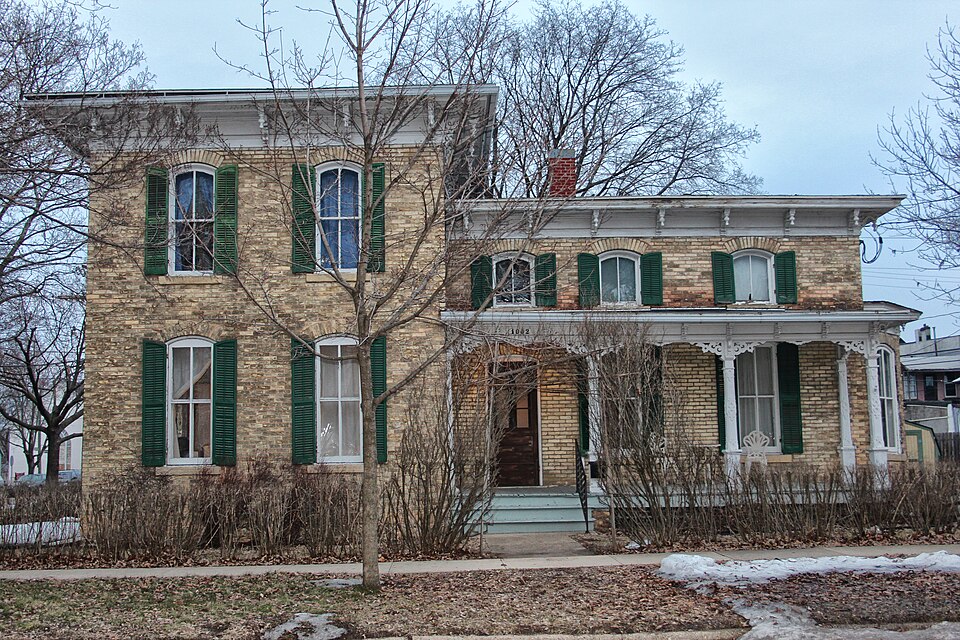
National Register reference number.79000083- the number the National Park Service assigned this property when it was listed, and the key its nomination file is catalogued under at the National Archives.
What happened here
An account from the chapter on Brodhead city. The inset identifies its exact
source book and publication year.
The first to manufacture wagons at Brodhead was William Spencer, who commenced here in 1857. He manufactured a few wagons and continued in the busiiK'ss until the war broke out, when he enlisted in the 18th Wisconsin regiment, and went into the service. At the battle of Sliiloh he was severely wounded; removed
The chapter on Brodhead City in History of Green County, Wisconsin, published 1884 names Brodhead. This is what it says, exactly as the scans read.
In the extreme eastern portion of Green county lies the village of Brodhead - one of the most important business centers in the southern part of the State. It is beautifully located, on an undulating prairie, which extends eastward from the Sugar river. The civil town in which the village is located is one of the banner subdivisions of Green county. The Sugar river, which winds its course to the west of the village, furnishes excellent water privileges here, which have been utilized, and now comprise a valuable concomitant of the village in propelling a vast amount of machinery. The inhabitants here are almost wholly Americans - people from the New England and northern States, who have brought with them the culture and refinement of the eastern States, the absence of which, in some portions of the west, is so painfully apparent. Brodhead is by no means an old town, yet a quarter of a century and more has passed since its inception. Almost a generation has come and gone since Brodhead became a fixed fact. While there is nothing remarkable in the changes that have been wrought, there is a great deal to occupy the attention of the historian and attract the interest of the reader.
The plat of Brodhead covers all of section 25, and portions of sections 24 and 36, township 2 north, range 9 east. The Mineral Point branch of the Chicago, Milwaukee & St. Paul Railway passes through the village from east to west, and a branch of that line of railway has been extended from this place to Albany. The Sugar river touches the northwest corner
Regional context, not property-specific
evidence. The
federal wildfire occurrence database
lists 14 fires within 5 miles of Francis West Smith House
between 2018 and 2020, burning about 12 acres in total. None started naturally. 1 was recorded as arson.
Distance is straight-line from the map coordinates, so a fire counted
here may appear on a neighbouring settlement's page as well.
Reported cause
Fires
Debris and open burning
7
Smoking
3
Power generation/transmission/distribution
1
Arson/incendiarism
1
Equipment and vehicle use
1
Missing data/not specified/undetermined
1
The most recent of
them, most recent first, with the day each was reported and the service
that recorded it.
Regional context, not property-specific
evidence. The federal mineral resources record lists
5 workings within 5 miles of Francis West Smith House: 3 past producers, 1 producer, 1 unknown.
1 still produces. What was taken out: Stone, Crushed/Broken, Sand and Gravel, Construction, Stone. Distance is straight-line from the
map coordinates, so a quarry counted here may appear on a neighbouring
settlement's page as well.
Regional context, not property-specific
evidence. The National Weather Service names
Brodhead, the town this property stands in, in 35 storm reports between 1994 and 2023: 12 thunderstorm wind, 10 hail, 7 flood, 3 funnel cloud.
No death or injury is recorded in these reports. Each account below is quoted exactly as the forecast office
filed it, from the NOAA Storm Events Database, and each date
opens the federal record of that event.
Tornado started just south of Decatur Lake and tracked to the north through Decatur Lake Golf Course, causing some minor tree damage. Further to the north, a barn had roof damage with a number of sheets of metal lofted off of the building. Tornado tracked into a small portion of Rock County before disapating.
The Green County Emergency Manager reported $100,000 of damage from severe thunderstorm winds 4 miles southwest of Brodhead. The damage included 2 barns/sheds with one losing it's roof to the powerful winds. The severe winds peeled siding off of one home, and broke windows and pushed in the door on another home.
The river gauge on the Sugar River in Brodhead remained above flood stage from the afternoon of June 24th into early July. The creek experienced moderate flooding, cresting at 8.86 feet at 2:00 AM CDT on June 28th, which is 3.86 feet above flood stage.
The Sugar River reached moderate flood stage, cresting at 9.59 feet in Brodhead. There is widespread flooding of lowland and agricultural land in the Brodhead area. Floodwaters cover roads about 6 miles downstream into the Avon Township of Rock County. Floodwaters are over Highway T which is on the border of Green and Rock Counties.
The Sugar River at Brodhead crested at 8.72 ft., which is moderate flood stage. There is widespread agricultural land flooding in the Brodhead area. Some roads are either closed or experience minor flooding, including Ten Eyck Rd. Downstream, floodwaters are over County Road T which is the border of Green and Rock County.
The Sugar River near Brodhead experienced minor flooding, cresting at 7.02 feet, or 2.02 feet over the flood stage of 5 feet, at 4 AM CDT on April 12th.
The Sugar River at Brodhead reached moderate flood stage, cresting at 8.63 ft. There is widespread agricultural and lowland flooding in the Brodhead area. Floodwaters are over Highway T which is on the border of Green and Rock County.
The Sugar River reached moderate flood stage, cresting at 9.29 feet in Brodhead during the early afternoon of August 23rd. There is widespread flooding of lowland and agricultural land in the Brodhead area. Floodwaters cover roads about 6 miles downstream into the Avon Township of Rock County. Floodwaters are over Highway T which is on the border of Green and Rock Counties.
General public reported a swath of downed trees from Martintown to northwest of Brodhead. Scattered pockets of felled trees were reported in a band about 3 miles wide.
No historic map-sheet match is published
for this property yet. That does not mean no map exists. This record needs
a coordinate-quality review before it can be joined to a sheet boundary.
Browse the county's mapped places while that work is
pending.
Listed places nearby
2 within 8 miles
Other National Register properties close
enough to walk or drive between, ordered by distance from this one. Both
positions come from the same geocoding pass that matched these properties
to their map sheets.
Listing record. National Park Service National Register of Historic Places, listed-properties dataset, current to 2026-05-22.
Map join. Address geocoded through the United States Census geocoder, then tested against the published boundary of every sheet in the USGS Historical Topographic Map Collection.
How this page is made. Listing fields come from federal records; map-sheet coverage is a labelled coordinate-to-boundary calculation, not a source-field claim.
Wildfire. Short, Karen C. 2022. Spatial wildfire occurrence data for the United States, 1992-2020 [FPA_FOD_20221014]. 6th Edition. Fort Collins, CO: Forest Service Research Data Archive. https://doi.org/10.2737/RDS-2013-0009.6 Collected with United States Government funding and usable without additional permissions or fees.
Mines and quarries. USGS Mineral Resources Data System (MRDS) https://mrdata.usgs.gov/mrds/ A work of the United States government, no copyright under 17 U.S.C. 105.
Storms. NOAA National Centers for Environmental Information, Storm Events Database https://www.ncei.noaa.gov/stormevents/ A work of the United States government, no copyright under 17 U.S.C. 105. Narratives are quoted verbatim from the National Weather Service report and are not edited or summarised.
 Block